ArcGIS Online has just been updated with the following new features and enhancements. This release includes updates and new capabilities for smart mapping, item pages, improvements to the map viewer and scene viewer, updated content, and more. For additional details see the What’s new help topic.
Smart Mapping
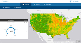
Smart mapping provides data-driven tools that enable you to explore your data to unlock information and easily author visually appealing web maps. When feature layers are added, the data is analyzed and appropriate layer styling options are presented in a streamlined user experience appropriate for your data.
With this release, several new smart mapping styles are available to help visualize, explore, and understand your data from a temporal perspective.
Continuous Timeline (Color) lets you use a new/old or before/after theme to show the age of your features using colors. Continuous Timeline (Size) uses symbol size to show time values, for example newer features can be larger, and older features can be smaller. Age (Color) and Age (Size) let you symbolize dates and ranges with color and size, and apply Themes such as Above and Below, High to Low, Centered On, and Extremes to explore your data.
See examples with descriptions by viewing the Show Time in Your Maps story map.
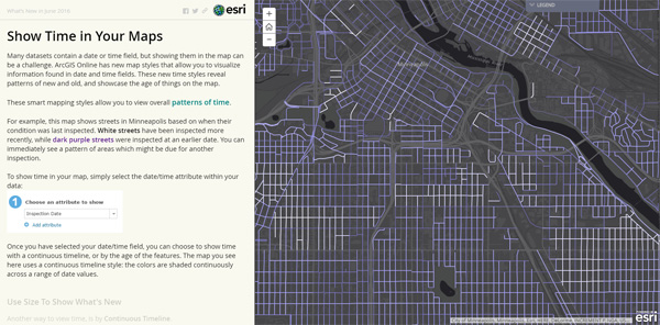
For more information see Change style and What’s New in Smart Mapping (June 2016).
Improved Item Pages
Item details have been redesigned featuring a new layout that improves workflows and information presentation. The new item pages also add capabilities and functionality that help you explore and work with content. For content consumers, the new pages provide more ways to explore items. For content creators and administrators, the new design makes it easier to modify item properties and configure settings. Improvements include:
- In-place editing of item descriptions and other details
- Better organization of information via a tabbed layout
- Improved workflows for saving layer defaults and publishing
- Improved workflows for configuring editing, and edit tracking
- Table and field editing, including support for related tables
- Layer styling directly from item pages, including symbols and pop-ups
- Create apps and scenes directly from item pages
- Enhanced comment management, including email notification
- And more…
See Introducing a new experience for working with items in ArcGIS Online for more information.
Map Viewer
Map viewer is the ArcGIS Online app that enables you to author and share web maps, perform analysis, and work with your layers. The following are map viewer enhancements for this release:
- New smart mapping styles for temporal data.
- Data can be filtered by date, for example you can filter for data within the last week or within the last two months.
- Routes are easier to share with apps such as Navigator for ArcGIS and in web and desktop apps. Create your route in the map viewer, save the route layer as an item, and share it through the item page.
Scene Viewer
Scene viewer is the ArcGIS Online app for authoring and interacting with 3D scenes. New in this release:
- Integrated mesh support, a new layer type for UAV or airplane-based photogrammetric 3D scans of surfaces (published by Drone2Map for ArcGIS and third-party vendors).
- Custom 3D object symbols
- Performance vs quality settings to optimize the user experience for browsers and high-end devices.
- New Daylight tool introduces sunlight and shadow animation over a day or an entire year.
Configurable Apps
Configurable app templates enable you to create custom user or workflow-focused apps that meet specific needs, without requiring programming.
This release includes updates and improvements to existing apps, including:
- A new version of Basic Viewer is available with better support for keyboard navigation to improve web accessibility. The configuration pane also now has an option for defining alternate text for the map.
- A new version of Time Aware is available with better options for date and time formatting, plus a new option for displaying the last 24 hours.
- 3D Data Visualization includes new visualization options for pulsing points and animating point extrusions and polygon extrusions.
- Crowdsource Manager has been enhanced with new options for enabling attribute and time filters, displaying editable and non-editable layers, viewing and editing related records, and batch updates of feature attributes.
See the Configurable Apps Gallery.
Story Maps
Story Maps let you combine authoritative maps with narrative text, images, and multimedia content, making it easy to harness the power of maps and geography to tell your story.
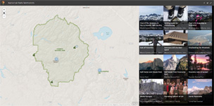
Story Map Cascade (beta)

Story Map Cascade allows you to create immersive, full-screen stories using your narrative text, maps, scenes, images, and videos. Cascade stories are visually compelling yet easy to navigate; readers simply scroll through the story. View 100 Years of National Parks to see an example.
Story Map Crowdsource (beta)
Story Map Crowdsource allows you to publish and manage a crowdsourcing project to which anyone can contribute photos with captions. Use Story Map Crowdsource to engage your audience and collect their photos and experiences, thoughts, or memories on the subject of your choice, all linked to a map. A vetting function lets you review and approve contributions. View National Park Memories to see an example.
To create stories using these apps go directly to the Story Map Cascade and Story Map Crowdsource web pages to learn more, see examples, view a tutorial, and use the interactive builders.
For more information see What’s New in Story Maps (June 2016).
Web AppBuilder for ArcGIS
Web AppBuilder enables you to easily create HTML/JavaScript apps that run on any device, using a gallery of ready-use-widgets. You can customize the look of your apps with configurable themes, and can host your apps online or on your own server.
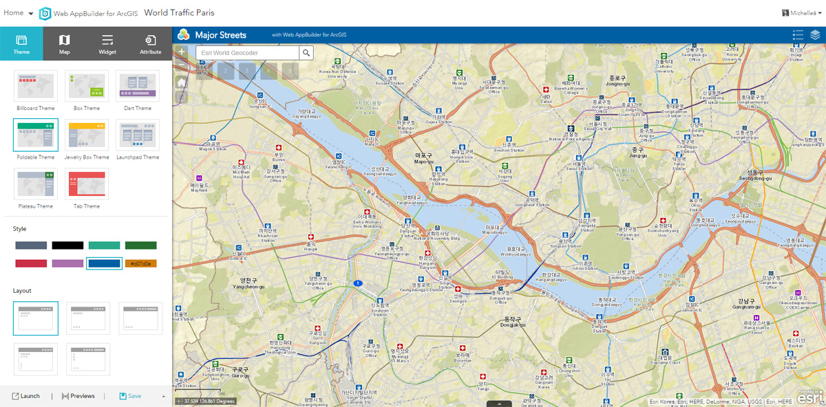
Enhancements and new capabilities for Web AppBuilder for this release include the following:
New widgets
- Add Data enables you to search for layers in ArcGIS Online and enter URLs to add data to the map.
- Filter enables you to filter features.
- Group Filter allows you to create groupings of layers to apply a value filter to. You have the option of saving and reloading your defined groupings so that you can come back anytime and resume your work.
- Oblique Viewer displays images in their native coordinate system. This allows you to pan in oblique mode, in a single viewing angle, or switch angles to view an area of interest from different perspectives.
- Select enables other widgets to take an action on the selected features.
- Share enables a social sharing experience of apps.
- Smart Editor extends the core editing widget with smart attributes, preset field values, record validation, and viewing pop-ups during an edit session.
Enhancements to existing widgets
- Query has been extended to include spatial relationships such as intersect, overlap, and contain so you can perform the query against features in another layer. Results can be exported as a CSV, GeoJSON, or feature collection.
- 3DFx has been enhanced to include more effects for 3D animation.
Other enhancements
- You can now create a theme color style using your own color choices, or match your organization’s color palette.
For more information, see Web AppBuilder for ArcGIS and What’s New in Web AppBuilder (June 2016).
Drone2Map for ArcGIS
Drone2Map for ArcGIS will be released shortly after this ArcGIS Online update, and will be available for all organizations to try or purchase. Drone2Map for ArcGIS streamlines the creation of professional imagery products from drone-captured still imagery for visualization and analysis in ArcGIS. Create orthomosaics, 3D meshes, and more, in minutes, not days.

See the Drone2Map website or the Drone2Map story map for more information.
Collector for ArcGIS
Collector for ArcGIS puts mapping in the hands of your field workforce, improving accuracy and currency of your spatial data.

The next update of Collector for ArcGIS will include the following enhancements:
- New Location Provider and Correction Profile settings in support of high accuracy GPS data collection.
- Improved display of location and its accuracy.
- Attach GPS accuracy to the features you collect and update.
- Various bug fixes and improvements.
For more information, see the Collector for ArcGIS help.
Survey123 for ArcGIS
Survey123 for ArcGIS is a simple and intuitive form-centric data gathering solution that makes creating, sharing, and analyzing surveys possible in a few easy steps.

Use the mobile app to download forms and capture data while in the field. Use the web site to create and publish surveys and view the results. Survey123 for ArcGIS can be used in combination with other field apps such as Workforce for ArcGIS, Navigator for ArcGIS, and Operations Dashboard for ArcGIS to optimize planning, coordination, monitoring and execution of field operations.
Workforce for ArcGIS
Workforce for ArcGIS provides tools that enable you to coordinate your workforce and view the real-time status of assigned tasks. Workforce for ArcGIS will be released shortly following this ArcGIS Online update.

Workforce for ArcGIS can be used with Navigator for ArcGIS, Collector for ArcGIS, and Survey123 for ArcGIS. Mobile workers receive and complete work that is assigned to them and can collaborate as a team in the field. Dispatchers create and assign work to mobile workers directly inside of ArcGIS Online. GIS administrators can create projects that manage the work that needs to be completed, assign crews, and configure the apps that will be used to complete the work.
GeoPlanner for ArcGIS
GeoPlanner for ArcGIS helps you plan, visualize, and test land use, natural resource, and landscape architecture scenarios with real-time dashboarding and sketch tools. GeoPlanner uses the power of Geodesign to help you make informed and evidence-based decisions about development and conservation.
The hosted version of GeoPlanner will be updated with the following new features and capabilities:
- A new analysis service that allows you to combine and weigh different Green Infrastructure layers to create suitability models.
- Ability to use new Green Infrastructure datasets as scenarios and assessment layers in GeoPlanner dashboards.
- Ability to import more features into a GeoPlanner scenario to help you model your plans and designs on existing data.
For more information see GeoPlanner for ArcGIS.
ArcGIS Maps for Adobe Creative Cloud (beta)
ArcGIS Maps for Adobe Creative Cloud is a new ArcGIS app that enables design and communications professionals to access thousands of data-driven maps inside Adobe’s design apps.
Download street, political, and physical features, man-made and natural event layers, satellite images, and many more maps, directly into Adobe Illustrator or Photoshop as editable vector layer or high-resolution images.
ArcGIS Content
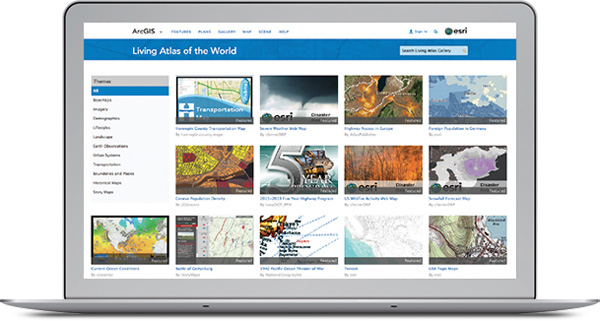
ArcGIS includes a Living Atlas of the World, a curated and continually updated collection of authoritative maps and layers covering thousands of topics. These data can be directly integrated into your workflows, and used to complement your data when authoring maps and apps.
Updates for this release include:
- Detailed boundary layers for several dozen countries have been added to the Living Atlas and made available for display and analysis in the map viewer and other ArcGIS apps.
- Beta versions of Esri vector basemaps have been updated. See all vector basemaps in the Vector Basemaps group. Also see Updates to Esri Vector Basemaps.
- World Street Map, World Topographic Map, Light Gray Canvas, Dark Gray Canvas, and Reference layers have been updated for North America.
- World Street Map has been updated to include detailed data for China with English labels, referencing authoritative map services built and maintained by the National Geomatics Center of China. Similar maps with Chinese labels are available to users in China and elsewhere.
- World Imagery has been updated to include National Agriculture Imagery Program (NAIP) 2015 1m imagery for 27 states in the continental United States, which is visible at large scales (Levels 14-17), as well as other community contributed imagery. View story maps with details on recent updates.
- A new Imagery map in Geographic Coordinate System (GCS) WGS84 projection is available. The imagery map includes the same imagery as the standard World Imagery map in Web Mercator, with added coverage in the polar regions. The new imagery map supports 3D display in apps such as ArcGIS Earth as well 2D display for apps that use the GCS coordinate system.
- A new World Topo base layer (beta) has been published that can be used in 3D or 2D apps that require a detailed basemap without labels. View item pages.
- The National Agriculture Imagery Program (NAIP) image services, which include multi-spectral and multi-temporal imagery for the continental United States, have been updated to include NAIP 2015 imagery for 27 states. The NAIP image services now include NAIP 2010-2015 imagery, with 2-3 vintages of imagery for each state for comparison purposes.
- Demographic maps for the United States have been updated with the latest 2016 estimates and 2021 forecast data.
- Boundary layers from the Living Atlas Analysis Layers gallery are now available in the Living Atlas gallery of layers to be used for visualization.
For the latest information on content updates, see the ArcGIS Online blog.
Analysis
- Detailed boundaries for several dozen countries have been added to the Living Atlas analysis layers.
- When working with variables for data enrichment, you can now save favorites.
- You can now perform analysis on OGC WFS layers.
- Organizations can configure a custom analysis layers gallery.
- Origin Destination Cost Matrix, a new network analysis service, is now available in beta. This new service computes a table of travel distances or travel times between many known locations. It is available through the REST API, the Web AppBuilder for ArcGIS Geoprocessing widget, and the Network Analyst tools in ArcGIS Pro 1.3 and ArcMap.
ArcGIS Marketplace
ArcGIS Marketplace is the go-to destination to discover, access, and trial ready-to-use apps and content that are designed to extend ArcGIS. Marketplace features apps from Esri and qualified Esri Partners, International Distributors, and startups who are Marketplace Providers.

New for this release:
- E-commerce integration, enabling easier purchasing and access options for users around the world.
- Global access to try and buy Esri premium apps including Drone2Map, Navigator for ArcGIS, Business Analyst Online, Community Analyst, GeoPlanner, and more.
- Improved rating and comments for easier browsing and selection.
For more information see the ArcGIS Marketplace help.
Hosted Web Layers
Hosted web layers are used to publish your maps and data in ArcGIS Online, outsourcing the need for your own server and infrastructure, or complementing what you do using ArcGIS for Server. This release introduces the following new capabilities and features:
- The performance of polygon and polyline hosted feature layers can be optimized by storing a generalized representation of the feature geometry at smaller scales. This optimization is ideal for data such as ZIP Code boundaries where exact precision may not be necessary when viewed at the state level but is necessary when viewed at larger scales, such as county level.
- Date fields now support queries which can calculate the difference in days between two dates, and report features relative to the current date.
- Hosted feature layers now offer better control of who can make edits in crowdsourced apps; layer owners and administrators can disable the ability for anonymous users to update or delete existing features.
Open Standards
ArcGIS Online continues to improve its commitment to open standards and interoperability with enhanced support for Open Geospatial Consortium (OGC) services. The following functionality is now supported:
- Pop-ups can be enabled in OGC Web Map Service (WMS) layers.
- OGC Web Feature Service (WFS) layers can be added to maps and as items.
- Third-party OGC Web Map Tile Service (WMTS) services can be added as items.
Organization Administration
Organization Administrators have more options for managing credit budgets and can now set a default credit allocation for new members. Organizations can also manage credit budgets as part of the invitation process.
Enterprise logins can now be enabled for Esri access, providing members using enterprise authentication access to Esri web resources for support, training, forums, downloads, email communications from Esri, and more.
Organizations can configure a custom analysis layer gallery to use with the analysis tools in the map viewer.
Workflows for sharing content between organizations have been improved. Administrators can now make a member’s profile visible to everyone (public) so the member can be invited to groups outside the organization. New documentation explains how to share an item with another organization.
For enhanced login security the user name and password cannot be the same. This requirement applies to new accounts (including trials) and existing accounts that reset the password.
Members can now be designated as Marketplace purchasers. These members are entitled to buy apps listed in the ArcGIS Marketplace through the new online Esri shopping cart.
For more information
For additional details about this release, see the What’s new help topic or view all posts related to this release.


Article Discussion: