ArcGIS Online has been updated with the following enhancements to Esri Story Maps.
In this release we are excited to introduce two new storytelling applications that you can use to create story maps to engage your audience in new ways.
Story Map Cascade (Beta)
This new application allows you to create immersive, full-screen stories using your narrative text, web maps, 3D web scenes, images, and videos.
Cascade stories are visually compelling yet easy to navigate: your readers simply scroll through your story. As they scroll, their screen is filled with beautiful images, compelling maps and scenes, and other rich media, all woven into your narrative. The Cascade cover lets you grab your audience’s attention and set the scene for your story with a great-looking image or video:
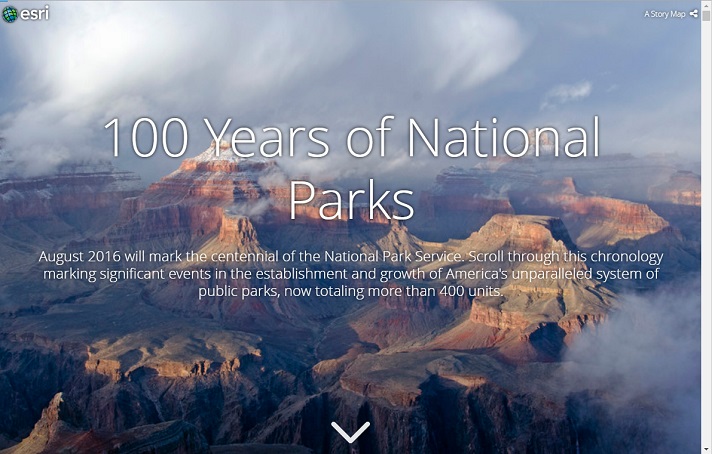
See this Cascade example: 100 Years of the National Park Service.
The Story Map Cascade interactive builder makes it easy to author your story. It includes built-in support for web scenes, the ability to instantly search all of Flickr for photos (not just a specified Flickr account), and the option to upload images directly into your story from your computer. We think Story Map Cascade will let you take your storytelling to the next level.
To create a Cascade story, go to the Story Map Cascade page on the Esri Story Maps website.
Story Map Crowdsource (Beta)
This new application allows you to publish and manage a crowdsourced project to which anyone can contribute photos with captions.
Use Story Map Crowdsource to engage your audience and collect their photos and observations, experiences, thoughts, or memories on the subject of your choice, all linked to a map, and presented beautifully:

See this Crowdsource example: National Parks Memories.
As a Crowdsource story author you can choose to allow people to contribute to your story by signing in with their Facebook, Google, or ArcGIS account, or with a guest option. A vetting function in the Story Map Crowdsource Builder lets you review and approve contributions. You can opt for your story to display new contributions immediately (which you can then review to remove any unwanted content) or for your story to only display contributions after you have reviewed and approved them). When you wish you can close your story to new contributions but continue to make it available for people to browse and enjoy.
Authoring a Crowdsource story requires that you have an ArcGIS subscription account with publishing privileges. This is because the content that people contribute to your story is automatically stored in an ArcGIS feature service created with your account.
Important note: Story Map Crowdsource is different from the other Story Maps apps in that it enables people to post pictures and information onto your map. Unlike the other apps, where you do all the authoring, you don’t have complete control over what content appears in your Crowdsource story. You’ll need to review contributions to check for inappropriate or unwanted posts, and you also need to consider privacy issues.
For example, a contributor’s current location, such as their current street address, can be exposed in a Crowdsource story, and appear with their post on your map both as a point location and as text. This is OK if your story is soliciting contributions about, say, great places to visit in a city, where that location is a public place and you want that place’s location to appear on your map. But it may not be desirable for other subject matter, especially if people may be posting onto your Crowdsource story from their home.
It is up to you as the author of a Story Map Crowdsource story to ensure that your application complies with the privacy and data collection policies and standards of your organization, your community, and your intended audience. We recommend that you set up a limited pilot or internal test of any Story Map Crowdsource project before deploying and promoting a Crowdsource story publicly, in order to review if it meets those requirements.
To create a Crowdsource story, go to the Story Map Crowdsource page on the Esri Story Maps website.
In addition, this blog post describes how to do additional customization of the Story Map Crowdsource contribution panel that your participants see. This can help you provide more direction about the information you want your audience to contribute, and it also provides an easy way to create a story for an audience that speaks a language other than English.
Give us feedback on the Cascade and Crowdsource Betas
Story Map Cascade and Story Map Crowdsource are currently in beta. We’re looking forward to getting your feedback on these releases. Please connect with us in the Story Maps Forum on Geonet. Stay tuned for future updates, as we’ll be adding new features that further enrich the storytelling capabilities of these apps!
As beta releases, you can create Story Map Cascade and Story Map Crowdsource stories by going to the Esri Story Maps website. These beta apps don’t appear in the default ArcGIS Online configurable app gallery, but they can be added in by your ArcGIS Online Organization administrator. Stories you create with the betas will still work with the final releases. At beta, Cascade and Crowdsource stories you create do not appear in the My Stories section of the Story Maps website. You can manage the stories you create with these new apps in My Content in ArcGIS Online.
Other Story Maps news
- We’re looking forward to meeting you at the 2016 Esri User Conference in San Diego. Here’s a blog post detailing Story Maps activities at the UC.
- Come and learn storytelling using the power of maps at the Esri Story Maps Pre-User Conference Seminar on Sunday June 26th, 2016 in San Diego. This unique full-day seminar is led by Allen Carroll, the Esri Story Maps program leader and master storyteller.
- Look out for the results of the Esri Storytelling With Maps contest, which will be made public during the User Conference. Congratulations to our winners!
- It’s now easier to keep track of new blog posts and articles from Esri that help you make the most of Story Maps. We now post entries into the Story Maps Forum on Geonet to let you know about new blog posts and articles that might be of interest. So follow us on Geonet to find out the latest.
- The Support page on the Story Maps website has been renamed to the Resources page and redesigned to make it more useful.
For more information about story maps and how to create and manage them, visit the Story Maps website.

Article Discussion: