Maps rich with data analysis are used as a tool in many different ways to help users make better-informed decisions. Esri’s geographic information system (GIS) technology puts information in a geographic context. The element of place is one everyone is familiar with already, but to be engaging, a map needs to go beyond its function. This is why the aesthetics of mapping are so important to Dr. Kenneth Field, Esri senior cartographic product engineer. “There are reasons why people love historical maps,” said Field. “They’re pieces of art as well as well-designed technical products. A map that is well designed, where care has been taken as to the form as much as the function, is one of the reasons why people want to look at some maps over others.”
Field spent 20 years in the United Kingdom teaching cartography and GIS. For the past six years, he has been Esri’s resident mapmaker. “Usually they’re very experimental maps, because what I’m trying to do is push the software,” said Field. “That helps us internally, because it demonstrates all we can do, and it also pushes our users to reflect on what’s possible in an entirely Esri-focused workflow.”
His work at Esri has taken Field around the world to conferences on mapping, not only to demonstrate Esri’s capabilities but also to educate others about cartography using Esri’s GIS tools. One such conference, GeoCart, in New Zealand, allowed Field the opportunity to run a workshop on map design. His two-day preconference workshop has been such a successful part of the last three GeoCart conferences that the New Zealand Cartographic Society awarded him an honorary membership, making Field only the second person to receive this honor.
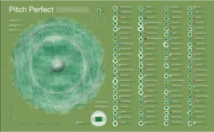
Dr. Field has also recently been honored by the British Cartographic Society, which gave him its top honor for an innovative map he presented at the society’s 2016 awards. The map illustrates the diversity in British football pitches (fields), showing the pitch dimensions and geographic orientations of 92 professional football clubs in England and Wales. Overlaying the centered and scaled aerial images of the pitches produced a spirographic pattern that was educational in showing how widely the pitches varied, and the information was unique in its presentation. “Purely by chance, the data created this beautiful kaleidoscopic image,” said Field. “I think the reason people liked it is that nobody had ever seen that kind of data handled and presented in that way before.”

The work Field conducts at Esri is focused on teaching others about everything the ArcGIS platform is capable of from a cartographic standpoint. He continues experimenting to find new ways to push the software forward as a tool for mapping as well as for making map products that people want to look at and explore—whether a printed map, a web map, or a 3D interactive scene.

In fact, cartography has been experiencing a renaissance lately. The demand for skilled cartographers has increased, due to the rise of interactive maps and the availability of map-making tools online that not only allow for greater data storage, but ease of mobility as well. The Bureau of Labor Statistics (BLS) projects that the profession will grow by 29 percent from 2014 to 2024, and was number one in the BLS ranking of Best Engineering Jobs.
Learn more about how the profession of cartography is in high demand: money.usnews.com/careers/best-jobs/cartographer
Check out more of Kenneth Field’s maps at carto.maps.arcgis.com/home/index.html and his award winning Pitch Perfect map here: https://carto.maps.arcgis.com/home/item.html?id=7d4dabb9a71c44aabdcf3d4444e451d4
insider