By Clint Brown – Director, Product Engineering, Esri
At Esri, we believe that geographic information system (GIS) technology provides a critical framework for understanding, communicating, and organizing information about our world. Underpinning our work at Esri is the belief that applied geographic science provides a powerful medium for understanding complex challenges and that, through the application of GIS, we can explore possible solutions. In light of this, we have been closely tracking the process of establishing the United Nations (UN) Sustainable Development Goals (SDGs), creating capabilities that will help create and monitor the SDG data indicators. We believe that Esri’s ArcGIS platform is highly relevant as an applied toolset to achieve the goals set forth in the 2030 Agenda.
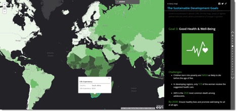
This story map is about the use of GIS to support SDGs. Visit sdgs.maps.arcgis.com/apps/MapJournal/index.html?appid=c921e7d2cfef4c8ab98b839e27eda74a.
A primary goal of GIS is to provide a framework for organizing and communicating the collective global knowledge about our world and the impact of human activities. GIS and maps are used in all fields across every nation, providing a universal language for communicating and sharing ideas and insight. They offer the unique capability of integrating many different kinds of data. GIS uses spatial location and digital map overlays to organize the content of our world. And overlays can be used to integrate information and analyze relationships among and between all SDG initiatives.
We believe that GIS can provide the underpinnings for the implementation and management of the Sustainable Development Goals. GIS can organize SDG information into various types of layers that can be visualized, analyzed, and combined to help us better understand the issues facing future development. GIS delivers a platform that can be used for the observation, tracking, and management of shared SDGs worldwide—an integrated global goals GIS. This creates a development nervous system for the planet that will integrate data across disciplines, support the evaluation of planetary health using global measures for SDGs, identify the results and impacts of development interventions, and be a platform for communication and understanding.
For example, for scientists, this global goals GIS will be a framework for advancing the application of geographic science to measure, analyze, and monitor indicators associated with the goals and the multitude of projects that support their achievement. For statisticians, this global goals GIS will be the platform used to collect, produce, manage, and share the data needed for decision-making. For policy makers, the global goals GIS will help focus where resources and initiatives should be supported on the ground and promote data-driven government action. For citizens everywhere, global goals GIS will be a platform for discovery, exploration, and sharing that can lead to an understanding of both local and global challenges. Through massive data contributions from current and future GIS users worldwide, this global goals GIS will represent a new way for us to comprehend the complexity of our world; understand, address, and communicate the sustainable development issues we face; and act collectively.
Esri provides GIS software, known as ArcGIS, to over 350,000 organizations worldwide. We support our customers in creating maps and analytics that guide activities in virtually every field of human activity. We also provide implementation consulting and educational support to our customers. Our primary goal is to advance the adoption and use of GIS to enable our customers to make a difference in the world, and we are proud to be working in support of the SDGs. With the adoption of cloud GIS, the last seven years of technology have generated a community of ArcGIS users that have populated a cloud-based GIS encompassing millions of petabytes of information in a shared environment spanning the globe.
We have further tailored this data ecosystem in order to give access to a curated collection of the best available GIS content provided by our users worldwide. The result is Esri’s Living Atlas of the World, a collection of thousands of maps, intelligent geographic layers, imagery, tools, and apps that are built by ArcGIS users worldwide as well as Esri and its partners. This incredibly rich catalog of geographic information is available through ArcGIS. It represents the collective work of the entire GIS community and goes far beyond any other map catalog in existence. It provides an enabling framework for SDG implementation across countries and jurisdictions. By any measure, ArcGIS is growing and expanding rapidly into being a comprehensive GIS of the world, where all layers and extents of information are made accessible. Our belief is that these contents will help power the adoption of and action on the SDGs throughout organizations and communities worldwide.
It’s no secret. For the SDGs to be an effective common agenda and gain broad acceptance, we must all rely on data from other organizations in addition to our own content. This capability to access geographic information on the web is transforming GIS, making it easy to access critical information layers for SDG monitoring and reporting. Web GIS helps organize access to content that is relevant to the SDGs. In turn, the ArcGIS system enables that content to be combined and used. The resultant information and applications can power broad use of SDG data and information to a global user base through open data sharing and engagement. This is further complemented by an extremely innovative, rich, and sophisticated set of standardized statistical and analytical tools for deriving deeper insight and conclusions from data layers in a GIS.

Insights for ArcGIS provides tools for spatial data exploration and understanding. Maps, charts, and tables appear alongside each other as cards. Each card is a live snapshot of the analysis. Apply a different style to each card and keep iterating. For an example, visit http://www.esri.com/products/arcgis-capabilities/insights.
Achieving the 2030 goals will require an unparalleled global effort. Esri has been committed to efforts such as this, providing support for the UN Millennium Development Goals (MDGs) and, more recently, through our SDG support activities. We believe that the SDGs provide a unique opportunity to improve our efforts that—for the first time—are accompanied by a common reporting system to orchestrate global development programs. SDGs represent an opportunity for global comparison and prioritization across the human and physical landscape. These goals are more aligned with GIS and geography than ever before.
Furthermore, it is essential to recognize that no Sustainable Development Goal can be achieved without consideration of other, related goals. Reducing poverty through measures that degrade the surrounding environment and disrupt essential ecosystem services is not a sustainable solution. GIS is the qualified approach to establishing systems of record to monitor progress toward specific goals while also enabling the holistic representation of essential interdependencies among these goals.
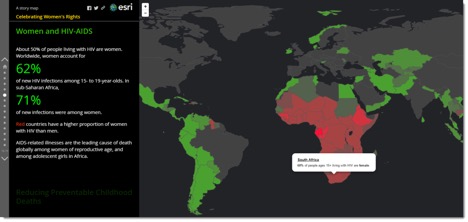
This story map, Celebrating Women’s Rights, is an example by Project Everyone about gender equality and its relationships to other key Sustainable Development Goals. Visit storymaps.esri.com/stories/2016/womens-rights/.
For over four decades, Esri has been focused on the development of a complete GIS platform that now serves millions of users around the world. We are fortunate to serve a community that comprehends the value of collaboration through GIS that fosters a larger vision and framework for understanding, communicating, and organizing information about our world.