Show me my home! The human era of GIS begins
Little more than a decade ago, seemingly the whole world snapped awake to the power of imagery of the earth from above. We began by exploring a continuous, multiscale image map of the world provided online by Google and other mapping companies. A combination of satellite and aerial photography, these pictures of Earth helped us to experience the power of imagery, and people everywhere began to experience some of what GIS practitioners already knew. We immediately zoomed in on our neighborhoods and saw locational contexts for where we reside in the world. This emerging capability allowed us to see our local communities and neighborhoods through a marvelous new microscope. Eventually, naturally, we focused beyond that first local exploration to see anywhere in the world. What resulted was a whole new way to experience and think about the world.
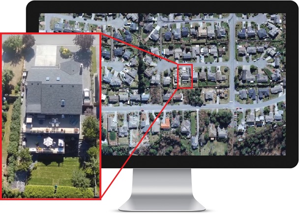
Initially, we zoomed in on our homes and explored our neighborhoods through this new lens. This experience transformed how people everywhere began to more fully understand their place in the world. We immediately visited other places that we knew about. Today, we continue by traveling to faraway places we want to visit. Aerial photos provide a new context from the sky and have forever changed our human perspective. This map tour visits selected areas in several communities where ultra-high-resolution imagery is available.
These simple pictures captured people’s imagination, providing whole new perspectives, and inspired new possibilities. Today, virtually anyone with Internet access can zero in on their own neighborhood to see their day-to-day world in entirely new ways. In addition, people everywhere truly appreciate the power of combining all kinds of map layers with imagery for a richer, more significant understanding.
Almost overnight, everyone with access to a computer became a GIS user.
A range of applications
By now, it’s apparent that imagery enables whole new perspectives and insights into your world and the issues you want to address. Imagery also has numerous advantages and capabilities.
Almost daily access to new information
Image collection is rapid and increasing. And access to imagery is increasingly becoming more responsive. Many satellites and sensors are already deployed with more coming all the time, collecting new data, adding to a continuous collection effort—a time series of observations about our planet. These image collections are enabling us to map, measure, and monitor virtually everything on or near the earth’s surface. All of us can quite rapidly gather much of the data that we need for our work. Imagery has become our primary method for exploration when we “travel” to other planets and beyond. We send probes into space and receive returns primarily in the form of imagery that provides a continuous time series of information observations. And it enables us to derive new information in many interesting ways.
Looking back in time
The use of aerial imagery is still relatively young. While imagery only began to be used in the twentieth century, it is easy to compare observations for existing points in time that reside in our imagery collections. In addition, we can overlay imagery with historical maps, enabling us to compare the past with the present.
Imagery data collections are becoming richer every day
Imagery is creating an explosion of discovery. Many imagery initiatives are repetitive and growing, expanding and adding to image databases for our areas of interest. ArcGIS is scaling out, enabling the management of increasingly large, dynamically growing earth observations. This points to the immediacy of imagery and its capacity for easy integration, enabling all kinds of new applications and opportunities for use—things like before-and-after views for disaster response, rapid exploitation of newly collected imagery, image interpretation and classification, and the ability to derive intelligence. Over time, many of these techniques will grow in interesting new ways, enabling deeper learning about our communities, the problems and issues we face, and how we can use GIS to address these.
Imagery enables powerful analytic capabilities
Imagery and its general raster format enable rich analysis using ArcGIS. And, in turn, these enable more meaningful insights and perspectives about the problems we want to address.
—–
This post is excerpted from The ArcGIS Imagery Book: New View, New Vision. Imagery is suddenly a big deal, and those who are adept at finding it, analyzing it, and understanding what it actually means are going to be in demand in the years ahead. The purpose of this book is to help everyone from GIS professionals to app developers, and web designers to virtually anyone how to become smarter, more skillful, and more powerful appliers of image data. The book is available through Amazon.com and other booksellers, and is also available at http://www.TheArcGISImageryBook.com for free.