Three companies describe how they use a location platform for commercial real estate. —–
Real estate is no longer just about “location, location, location.” It relies on location, information, and timing to identify and bring to completion the best developments. Having access to reliable, relevant, and timely location intelligence and insight allows real estate professionals to focus on the business at hand: delivering the best deals for all involved.
The right tools allow you to use insight, creativity, and objectivity to work out the best deal for you and your clients by applying the right information about particular locations to bring your vision to reality. Esri’s ArcGIS platform provides the tools and data you need to move on a decision quickly, and reap the benefits. Three different commercial real estate companies describe how they are able to address the business at hand using the ArcGIS platform.
Turning Location Information into Insight
CRE Tech helps commercial real estate professionals navigate technology and make their clients more successful. As a long time educator and partner of The Site To Do Business (STDB), the market leading online resource helping Certified Commercial Investment Member (CCIM) Institute members, CRE Tech is recognized as an expert in making more strategic real estate investment decisions.

“Esri provides our community with the context they need to understand property deals and people. This is indispensable information for us and our customers,” said Todd A. Kuhlmann, CCIM.
Matching Location to the Right Customer
Gary M. Ralston is a managing partner with Coldwell Banker Commercial Saunders Ralston Dantzler Realty, LLC, the premier commercial services provider in Central Florida (Polk County). As a senior instructor for the CCIM Institute, Director of the CCIM Institute, and CCIM Technologies educator and published author, Gary is a globally recognized expert on retail real estate development using both financial and location analysis.
“In theory you have a location, a site, and a building. You have to work through these filters to make a concept a success. Esri makes it easy for CCIMs to do this,” Gary said.
Gary is one of 13,000 CCIM commercial real estate professionals who have access to the ArcGIS-based Business Analyst Online, an online analysis and collaboration portal. Gary approached Manny’s Steakhouse, a successful franchise with three locations in Central Florida, with a site he envisioned as a potential new location.


Helping David Compete with Goliath
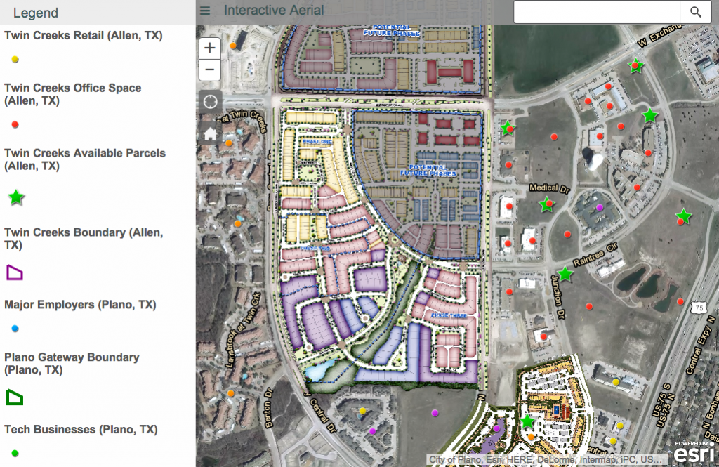
After working for four national commercial real estate firms over a 23-year period, David Hicks founded his own company, the David Hicks Company, eight years ago. The David Hicks Company is a four-person commercial real estate, consulting, and brokerage firm based in Allen, Texas. The company, with average annual sales of $25 million, provides vision and strategy to landowners, helping them maximize their land’s value and return on investment through planning, zoning, marketing and sales.
Once the sole domain of the larger real estate firms, location analytics is now within the reach of smaller firms through Esri’s ArcGIS Online. The size and complexity of Hicks’s projects require strategic alliances with architects, engineers, attorneys, and other professionals, like Esri partner Datastory Consulting.


Don’t be Hemmed In by Four Walls
ArcGIS opens new lines of business and keeps revenue streams healthy by helping you discover new opportunities for growth, expansion, and collaboration in individual markets as well as at regional and even global scales. The ArcGIS platform adds location. Location brings context. It helps separate fact from fiction. Keep up with changes, monitor the market, and put your analyst insight and experience to the best use.
insider