A great map often starts with a great basemap. It’s the canvas upon which we paint our operational layers, providing context and bringing them to life. Esri has published many different kinds of basemaps, including Streets, Imagery, Topographic, and more. These basemaps are continually updated as new information becomes available.
One of the most popular basemaps (and the default ArcGIS Online basemap) is the World Topographic basemap, also known as the “Community Basemap.” It’s a GIS crowd-sourced basemap that compiles data from many GIS users that participate in Esri’s Community Maps Program.
The basemap is compiled from the best available sources, and includes boundaries, cities, water features, physiographic features, parks, landmarks, transportation, and buildings. Updates are published monthly, and you can find more details on ArcGIS Online.
The original design for the basemap was based on a USGS topographic map. While recognizable to users in the US, it was not a design that people outside of the U.S. expected to see, and that’s one of the drivers for change. “The new design has more global appeal,” says David Watkins, Esri cartography product manager. “It underscores our commitment to the global community.”
Here’s a peek at the updated basemap, with the still-in-progress new design on the left, and the current design on the right:
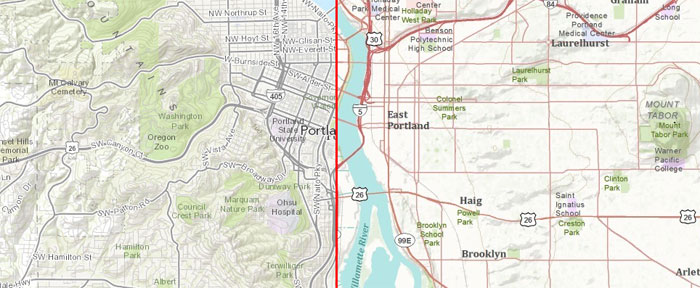
Features of the new cartographic design include:
- Unified global design
- Contemporary look and feel
- Provides a better background to overlay your data
- Consistent data across all map scales
“This release of the World Topographic Basemap shows Esri’s continued commitment to great cartography,” said Sean Breyer, ArcGIS Online content program manager. “The basemap provides an excellent canvas to overlay information, and with the new design will expand the color palette our users can choose from to display their data effectively.”
The World Topgraphic map is important to GIS users and Web developers, and is the basemap of choice for many maps and applications. It’s extremely popular, and that fact provides an opportunity to get a lot of feedback.
“The World Topographic Map gets several million map views each day,” says Deane Kensok, ArcGIS Online program manager. “The changes we’ve made are based directly on user feedback, and in reviewing the many ways the map is being used.”
Esri will be completing the update soon, working with the community of contributors from around the world. I’m definitely looking forward to its public release.