Jim Herries
Connect:

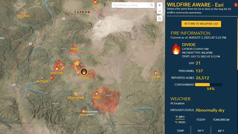
Jim Herries is a geographer with Esri in Redlands, California. He serves as Senior Principal Product Engineer and Product Engineering Lead, Cartography on the team responsible for ArcGIS Living Atlas of the World. Jim works with teams on thematic mapping and map visualizations, reflecting a drive to help GIS users bring their data to life on the map and stimulate insights. He constantly looks for ways to create clear, focused map information products that incorporate meaningful spatial analysis and evocative visualizations. When he started in GIS at Ohio State, he walked over to the campus library to transcribe census data by hand to paper so that he could hand-enter it into spreadsheets for upload into Arc/INFO for mapping and analysis. Today, he appreciates how web GIS brings everyone access to good data in useful layers and maps as a starting point for great work.

Posts by this author
New Updates for Wildfire Aware

App enhancements and updated demographics help to increase your awareness during fire season.

Continue Reading

Be Wildfire Aware within your own maps

The incident, population, and environment enriched layers from Wildfire Aware are now available as a live feed layer for your maps and apps.

Continue Reading

Wildfire Aware App Design and Implementation

The Esri team responsible for the Wildfire Aware app shares key design and implementation decisions.

Continue Reading

Index Maps Help Inform Strategies

You can show individual thematic maps to your audience and expect them to assemble the information in their mind. You can also make an index map.

Continue Reading

Justice40 tracts now available in Living Atlas

Esri recently released the latest Justice40 Tracts from the Council on Environmental Quality into ArcGIS Living Atlas.

Continue Reading

Updates to American Community Survey Layers Now Available in ArcGIS Living Atlas

Access the most current American Community Survey (ACS) five-year estimates from U.S. Census Bureau via ArcGIS Living Atlas of the World.

Continue Reading

Updates coming to American Community Survey layers in ArcGIS Living Atlas (Spring 2022)

The American Community Survey (ACS) layers in ArcGIS Living Atlas will be updated in March 2022 with the newest 2016-2020 data from the Census.

Continue Reading

Get (Re)Acquainted with Smart Mapping in Map Viewer

New ArcGIS StoryMaps collection on smart mapping

Continue Reading

A Straightforward Approach to Mapping Margins of Error

This blog digs into a simple approach to thematic mapping numeric data with their related error in a way that calls out significant error rates.

Continue Reading

1 2 3