The latest version of ArcGIS is now available! If you use the Spatial Analyst extension for performing raster analysis, read on for more details on the improvements to the capabilities and performance that have been made.
Where do I get it, and what’s changed?
To start off, use the following links to get to the download pages for ArcGIS Pro 2.1 and ArcMap 10.6.
For a quick summary of the changes, the What’s New topics are always good to check out:
Let’s break down the details into four categories:
- New and updated tools for the Spatial Analyst extension in ArcMap and ArcGIS Pro.
- Enhanced performance potential for Spatial Analyst tools in ArcMap.
- A new extension for image analysis in ArcGIS Pro.
- New Raster Analysis tools are available for scalable Raster Analysis through ArcGIS Enterprise.
1. Spatial Analyst extension
The Spatial Analyst toolbox has four new tools, and additional parameters have been added to several existing tools.
Distance toolset:
- A new tool, Cost Path as Polyline (Pro | ArcMap) is available. While similar to the existing Cost Path tool, with this new tool you can solve in one efficient step something that previously required two tools.
Generalization toolset:
- Nibble (Pro | ArcMap) has two new parameters to give you more control over the nibbling process. With Nibble NoData cells, you can now specify whether or not NoData cells in the input raster that are within the mask can be nibbled to a value, or remain as NoData. The Input zone raster parameter allows you to specify zones to control where nibbling occurs.
Hydrology toolset:
One new tool has been added to the Hydrology toolset, and two others have more parameter options available.
- Flow Distance (Pro | ArcMap) is a new tool for computing the minimum downslope distance for each cell to the stream into which they flow. This tool is particularly useful in flood modeling.
- Flow Direction (Pro | ArcMap) now supports two new algorithms for determining the direction of flow. A new parameter, Flow direction type, allows you to choose between the original algorithm (D8), multiple flow direction (MFD), and D-Infinity (DINF). In the original D8 algorithm, all flow is directed to the one neighboring cell with the steepest drop in elevation. The MFD algorithm uses an adaptive technique that partitions the flow from a cell to all of its downslope neighbors. The DINF method determines flow direction as a single angle taken as the steepest downward slope on the eight triangular facets centered at each cell. The MFD and DINF methods can diverge flow into more than one downslope neighboring cell.
- Flow Accumulation (Pro | ArcMap) now supports the new MFD and DINF flow algorithms in addition to the original D8. It also has a new option to create double precision output, allowing it to support more accurate values for larger flow accumulation values. In addition, it has been optimized to be faster and more scalable.
Interpolation toolset:
- Spline with Barriers (ArcMap) for ArcMap 10.6 has been updated to incorporate the improvements that were made when the tool was ported to ArcGIS Pro 2.0. Here is a blog post with additional details on this.
Segmentation and Classification:
Two new tools that utilize Deep Learning are available, Deep Learning Model To Ecd (Pro | ArcMap) and Export Training Data For Deep Learning (Pro | ArcMap). These tools are part of a workflow for working with Deep Learning models for classification. The deep learning classifier employs deep neural networks, which exploits the methodology of hierarchical explanatory factors. More complex features in higher levels are learned from simpler features at lower levels, based on training sample data.
For ArcMap 10.6, the following tools that were released with ArcGIS Pro 2.0 are now also available: Generate Training Samples From Seed Points (ArcMap) and Inspect Training Samples (ArcMap).
2. Parallel Processing
In ArcMap 10.6, certain Spatial Analyst tools have been updated to support Parallel Processing. By allowing multiple cores on your computer to be utilized, processing tasks on larger datasets have the potential to be completed more quickly. The list of tools that have been enhanced in this way are as follows, grouped by toolset.
- Distance: Cost Allocation, Cost Distance, Euclidean Allocation, Euclidean Distance
- Generalization: Nibble
- Hydrology: Fill, Flow Accumulation, Flow Direction, Sink, Stream Link, and Watershed
- Reclass: Rescale by Function
Please note, parallel processing for the above tools are not yet supported in ArcGIS Pro 2.1. However, we are planning to add it soon. In the meantime, Drew Flater has written an excellent blog post covering Parallel Processing in ArcGIS Pro. From there you can see that several Spatial Analyst tools already support Parallel Processing in ArcGIS Pro (Reclassify, Weighted Overlay, Weighted Sum, Viewshed 2, Zonal Statistics, Zonal Statistics as Table).
3. Image Classification extension
In ArcGIS Pro, the new Image Analyst extension is available. It is geared towards image analysts who perform manual image visualization, advanced remote sensing, and semi-automated image processing feature extraction. The extension offers a lot of new functionality and capabilities. Some of the analytical capabilities of tools previously found only in the Spatial Analyst toolbox are now also available as part of the Image Analyst extension through the Image Analyst toolbox.
4. Raster Analysis services through a Portal
Do you use ArcGIS Enterprise and have an ArcGIS Image Server license? With the Raster Analysis Portal tools (first released for ArcGIS Pro 1.4), we have some additional raster analysis capabilities available through ArcGIS Pro, Portal and Server. With this release, we have added eleven new tools.
Following are the tools as they appear in in the Raster Analysis portal in ArcGIS Pro, with the new ones highlighted.
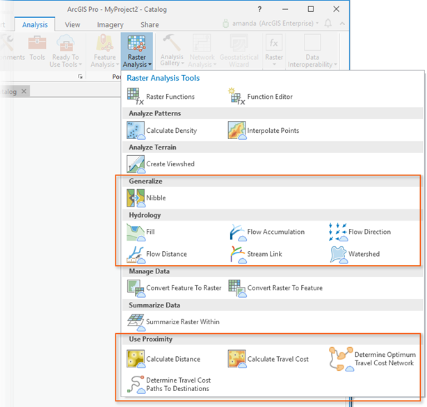
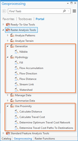
You can also access them via the Raster Analysis toolbox from the Portal tab in the Analysis > Tools > Geoprocessing pane.
Following is list of the new tools accompanied by a brief description of each. A link to the Pro Geoprocessing tool help is included, as well as a link to the REST API help for the corresponding Service tasks.
Generalize toolset:
- Nibble (Pro | REST API) can be used to simplify a raster by replacing cells corresponding to a defined mask input with the values of the nearest neighbor beyond that mask.
Hydrology toolset:
This is a suite of tools that can be used for modeling the flow of water across a surface.
- Fill (Pro | REST API) fills sinks in a surface raster to remove small imperfections in the data.
- Flow Accumulation (Pro | REST API) creates a raster of accumulated flow into each cell.
- Flow Direction (Pro | REST API) calculates the direction of flow out of each cell to its steepest downslope neighbor.
- Flow Distance (Pro | REST API) computes for each cell, the minimum downslope horizontal or vertical distance to cell(s) on a stream or river into which they flow.
- Stream Link (Pro | REST API) assigns unique values to sections of a raster linear network between intersections.
- Watershed (Pro | REST API) determines the contributing area above a set of cells in a raster.
Use Proximity toolset:
This toolset contains tools that help you analyze distance and proximity.
- Calculate Distance (Pro | REST API) calculates the Euclidean distance from a single or set of sources.
- Calculate Travel Cost (Pro | REST API) calculates the cost distance from a single or set of sources.
- Determine Optimum Travel Cost Network (Pro | REST API) calculates the optimum cost network from a set of input regions.
- Determine Travel Cost Paths to Destinations (Pro | REST API) calculates specific paths between known sources and known destinations.
Note: The new functionality introduced is not available in the Map Viewer at this release.
Some background on Raster Analysis in ArcGIS Enterprise
In order to have access to Raster Analytics, you will need to have an ArcGIS Enterprise deployment available to you. After ArcGIS Server is installed, ArcGIS Image Server will also need to be installed and enabled. Please see the following resources for more details on configuring and using these services.
Server
- What is ArcGIS Server
- What is ArcGIS Image Server
- Key concepts for image services
- Perform raster analysis
- Configure and deploy ArcGIS Enterprise for raster analytics
Portal
As an added bonus, and as Sara on the Enterprise team has noted in her recent blog post, the ArcGIS Enterprise documentation web help has been recently redesigned.
Summary
Above we’ve covered the important changes and improvements for raster analysis that have been introduced to the platform in ArcGIS Pro 2.1 and ArcMap 10.6 for you as a Spatial Analyst user. We’ve also touched on the functionality that is available with ArcGIS Enterprise through Portal and Server. Once you have downloaded the new versions, give the new capabilities a try. And as always, please let us know any difficulties you encounter.


Commenting is not enabled for this article.