ArcGIS Image Analyst, a new extension for ArcGIS Pro 2.1, was release in January 2018! We’ve built the Image Analyst extension to serve the operational needs of image analysts, scientists and photogrammetrists engaged in:
- Image interpretation, analysis and exploitation
- Creating information products from imagery
- Advanced feature interpretation and measurements from imagery
- Detailed feature compilation and measurement on stereo imagery
- Advanced raster and image analysis workflows for machine learning and feature extraction
Image analysts extract data and information from imagery using manual and computer-assisted methods. The Image Analyst extension provides advanced capabilities to support both image exploitation methods. With the extension, get access to stereo functionality, image space viewing, mensuration and raster exploitation tools, and integrated GIS and remote sensing functionality.
Stereo Mapping and Image Space Analysis support the collection of 3D feature data using standard feature creation and editing tools, saving feature class data in a geodatabase or as files, and sharing them in ArcGIS Enterprise. Computer-assisted image exploitation includes advanced image classification and a suite of raster functions and geoprocessing tools. Both functions and tools can be chained together into custom algorithms using raster functions templates and models, respectively. These processing chains can be deployed on the desktop or distributed processing environments in ArcGIS Enterprise either on-premises or in the cloud.
Stereo Mapping
Visualize and analyze imagery in stereo, and accurately collect 3D features in a stereo viewing and mapping system. Image Analyst includes:
- Stereo map viewer that displays and manipulates stereo image pairs from satellite, aerial, and drone sensor platforms.
- Tools to set up, enhance, and superimpose vector GIS data on stereo imagery, ground feature measurement tools, and a Stereo Model Manager.
- 3D cursor to measure and collect ground features directly into feature classes using standard ArcGIS Pro editing tools.
- Stereo viewing in two modes, active shutter glasses or anaglyph cyan/red glasses.
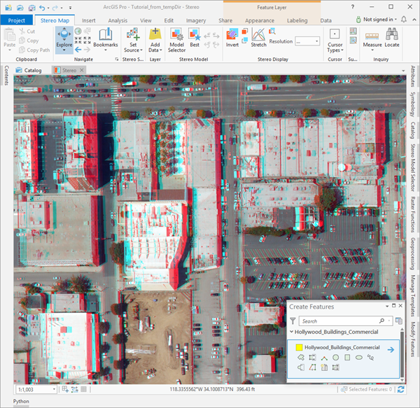
Image Space Analysis
Bring your GIS data to the image, not the other way around. Oblique imagery is often collected from all kinds of crazy angles, and projecting it onto a map can be disorienting and may not make sense. To deal with this, we’ve enabled you to work directly on the imagery in image coordinate space rather than map projected space. The image looks more natural, is easy to interpret, and the GIS layers you’re using to provide context to your imagery are displayed accurately.
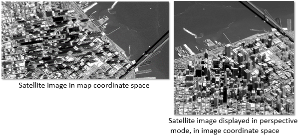
Collect feature data and perform mensuration in image coordinate space and save this data in your map projection of choice.
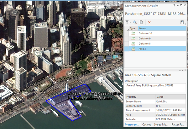
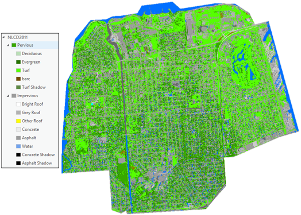
Image Classification
Perform object-based and pixel-based image analysis using image segmentation, machine learning classifiers, class map generation and refinement. The classification wizard guides you through the entire classification process including preprocessing and establishing your classification schema, image segmentation, training sample collection and management, class map generation, analysis tools for accuracy assessment of the training data and class map, and final class map editing tools and capabilities.
Raster functions and geoprocessing tools
Use more than 80 geoprocessing tools and 60 raster functions for image processing, including image classification, math and algebra operators. Use these tools to build, test and run your custom image processing algorithms and remote sensing techniques on a wide variety of imagery from satellites, aircraft and drones.
Get a 21-day free trial of the Image Analyst extension
The Image Analyst extension is available with ArcGIS Pro 2.1. Obtain a free 21-day trial copy of Image Analyst, and let us know your thoughts. Have fun compiling 3D features and processing your imagery!


Article Discussion: