For several years now, most world basemaps delivered on the web (including those from Esri) have been delivered in the Web Mercator coordinate system. To be precise, the Esri basemaps are delivered in the WGS84 Web Mercator (Auxiliary Sphere) coordinate system. This coordinate system is used by most consumer-facing mapping platforms and has become the de facto standard for web maps.
In prior years, Esri had delivered its world basemaps in Geographic Coordinate System (GCS) WGS84. We still host a couple ‘legacy’ map services (now in ‘mature support’ and not actively maintained) in GCS WGS84 to support users that had an affinity for that coordinate system or could not update their maps and apps. There are some organizations, such as in the Defense/Intelligence community, that have a requirement to use maps in GCS WGS84. To support these organizations and other use cases, Esri is introducing a new set of vector basemaps (now in beta) that are delivered in GCS WGS84.
Last year, Esri announced the availability of a new World Imagery (WGS84) tile layer in this coordinate system. This version of the World Imagery map features the same set of imagery that is published in our standard World Imagery map, but is delivered in a new tiling scheme (i.e. “WGS84 Geographic, Version 2”) based on the GCS WGS84 coordinate system. The new vector basemaps in GCS WGS84 are designed to complement the World Imagery (WGS84) map, so they can be used separately or together. You can see an example of this in the Imagery Hybrid map below, which combines the World Imagery (WGS84) tile layer and a hybrid reference layer built with the new vector tiles.
[iframe width=”100%” height=”400″ frameborder=”0″ scrolling=”no” marginheight=”0″ marginwidth=”0″ title=”Custom Canvas Map” src=”https://www.arcgis.com/apps/Embed/index.html?webmap=4c2b44abaa4841d08c938f4bbb548561&extent=-171.8262,-61.875,163.5645,90&zoom=true&scale=false&disable_scroll=true&theme=light&search=true”]
Map Styles
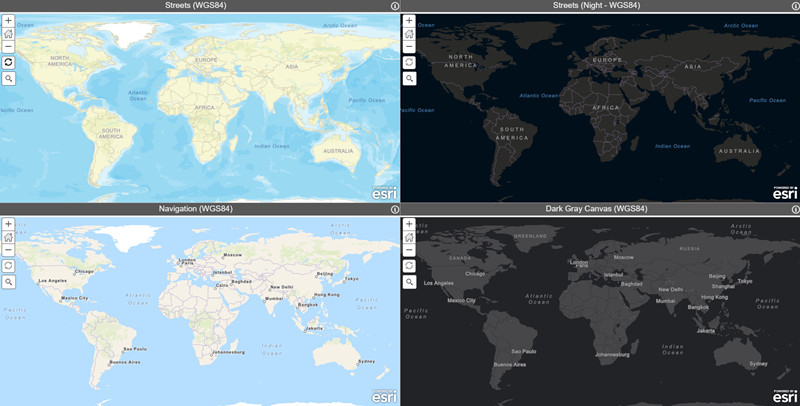
One of the advantage of vector basemaps is that they can support a wide range of map styles based on a single set of vector tiles. Esri intends to make available the same set of ‘core’ map styles (currently including 9 maps) for both our maps in Web Mercator and GCS WGS84. Esri will publish both web maps and vector tile layers for these vector basemaps. You can find these maps and layers in the Vector Basemaps (WGS84) group, and filter the group for what you need. If you would like to include these maps in your organization’s custom basemap gallery, we would recommend using the maps for that purpose.
“Small Print” Notes
- The vector basemaps in GCS WGS84 are currently in beta release and subject to change based on testing and feedback. The URLs for the vector tile layers will change when the beta release ends. Esri intends to update these vector basemaps in GCS WGS84 along with our standard vector basemaps in Web Mercator but they may not be perfectly in sync during the beta period.
- The initial beta release includes 6 of the 9 ‘core’ map styles that are planned for final. We will add the remaining 3 styles (e.g. Topographic, Streets with Relief, Terrain with Labels) in the next few weeks as we publish our new World Hillshade map in GCS WGS84.
- Vector tile layers are supported in web apps built with the ArcGIS API for JavaScript. This includes the ArcGIS Online Map Viewer, Scene Viewer, configurable apps, Web AppBuilder, and custom apps built with ArcGIS API for JavaScript. Vector tile layers are also supported in ArcGIS Pro. There is currently a known limitation with using the vector basemaps in GCS WGS84 in the Scene Viewer, which will be addressed in a software update soon.


Article Discussion: