At ArcGIS Pro 1.4 we introduced the Imagery tab. Now most of the commonly used raster tools can be accessed from a single location.
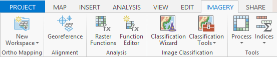
Here is a quick breakdown of what can be found on the Imagery tab:
- Ortho Mapping – Ortho mapping tools can be used to produce georeferenced ortho products from images from drones, satellites, and digital and scanned aerial photography. These products include georeferenced orthomosaic datasets, georeferenced orthomosaics stored as TIFF or CRF, digital elevation models (DEM), and digital surface models (DSM).
- Georeference – You can now georeference your imagery and CAD data in ArcGIS Pro. Use the Georeferencing tab to align rasters with your GIS data using Auto Georeferencing or by manually creating ground control points.
- Raster functions – The Raster Functions pane gives you access to several ready to use raster functions that can be used for various processing tasks such as radiometric correction, geometric correction, data management, visualization, and analysis.
- Function Editor – The Function Editor allows you to chain raster functions together into a single chain. These chains can be saved as RFT files, which can be applied to rasters attached to mosaic datasets/image services or shared to portal.
- Image Classification –The Image Classification Wizard guides users through several stages of the image classification process from preprocessing to segmentation, training sample selection, training, classifying, QA/QC to post-processing. The classification tools allow you to run specific classifications tools, independent from the entire Classification Wizard workflow.
- Process – The Process gallery contains some of most commonly used functions such as clip, mask, and difference. It is a subset of the entire suite of raster functions that ArcGIS Pro offers, but these process functions are set up for quick access and analysis.
- Indices – The Indices gallery contains several indices that can be used to identify phenomena in imagery such as vegetation, geology, water, or landscape.

Article Discussion: