ArcGIS 10.5 is a big release; arguably one of our biggest. In fact, we’ve introduced new server capabilities so big they inspired us to change the name of the whole ArcGIS for Server product family.
Analytics and sharing are at the heart of this release. A new app that changes the way you experience spatial analytics and the expansion of how you can share content using Web GIS are just two of the features that have us so excited about this release.
ArcGIS Enterprise goes live
ArcGIS Enterprise is the new name of the ArcGIS for Server product family that includes ArcGIS Server, Portal for ArcGIS, ArcGIS Data Store, and ArcGIS Web Adaptor. While the software components that make up ArcGIS Enterprise have remained the same, ArcGIS Enterprise offers new and exciting features that take Esri server software to a whole new level.
While we have enhanced the Portal for ArcGIS software component with 3D capabilities, new smart mapping styles, even more configurable web app templates– and have made it possible for you to bring Living Atlas data behind your firewall and use it completely disconnected from the open Internet — the most profound change that ArcGIS Enterprise introduces is the idea of the server role.
Server roles unlock capabilities within the ArcGIS Server software component. From our single server software component, you can spin up five different servers, each offering its own distinct set of capabilities, all of which can be scaled completely independently from each other. At 10.5 our servers are serving more than services – they are serving a purpose. This means you can now tailor your server architecture to provide the horsepower where your organization needs it. And because you can deploy our software on any infrastructure that meets the minimum system requirements, you can align our software with your organization’s technology strategy. Whether your organization is powered by the cloud, own data centers, or the machines that are the engines of your startup, ArcGIS Enterprise was built to fit.
Learn more about ArcGIS Enterprise.
The new analytics we love
In the Esri-verse we’ve always been about analytics, but at 10.5 we have some new additions that are real game changers.
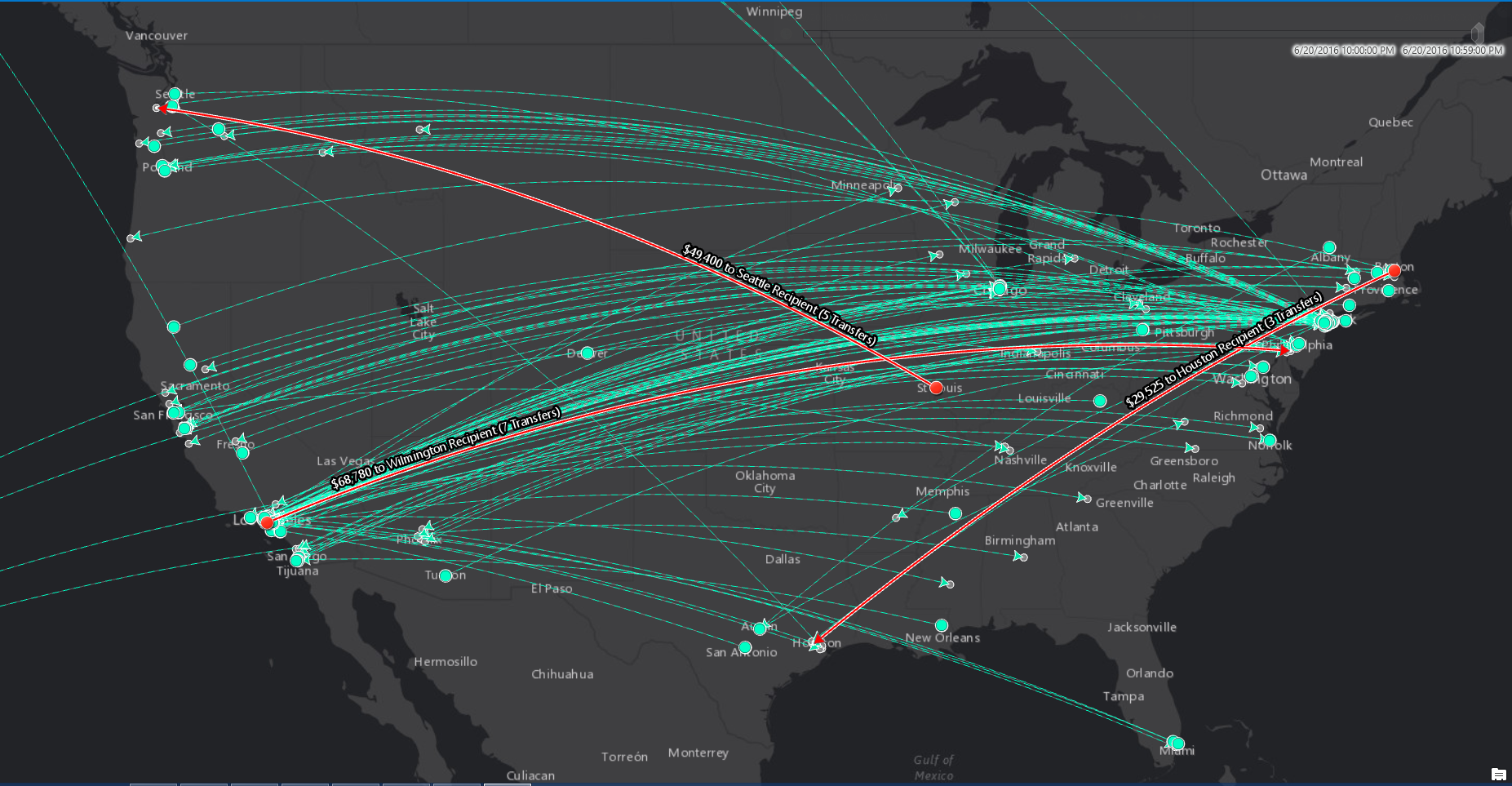
From ArcGIS Enterprise, ArcGIS GeoAnalytics Server and ArcGIS Image Server introduce distributed and parallelized computing, where the analytical load is distributed across multiple machines or multiple cores of the same machine, making it possible to analyze massive datasets in a fraction of the time of the time of a traditional workflow.
ArcGIS GeoAnalytics Server is designed for space-time analysis on massive vector and tabular data and can connect to your data in HDFS, Hive, existing ArcGIS data, and your local file shares. You can call the new GeoAnalytics tools from the upcoming ArcGIS Pro 1.4 release, from the Portal for ArcGIS map viewer; or if you prefer a non-mapping developer interface, you can use the ArcGIS REST API or the new ArcGIS Python API.
Learn more about ArcGIS GeoAnalytics Server.
The raster analysis capabilities of ArcGIS Image Server allow you to produce persisted, full-resolution raster and imagery output by running simple analysis tools or by chaining analytical functions together to create raster models that can answer even the most complex questions.
Check out the new ArcGIS Image Server.
Another extension turned server role, ArcGIS GeoEvent Server as part of ArcGIS Enterprise replaces the ArcGIS Server GeoEvent Extension available in previous releases. GeoEvent Server is designed to handle high volume, high velocity real-time and streaming data and provides solutions through on-the-fly analysis and dynamic aggregation of large datasets making data visualization simple. When connected to the base ArcGIS Enterprise deployment GeoEvent Server can archive data to the spatiotemporal data store allowing for further and future data analyses.
Get real-time GIS with ArcGIS GeoEvent Server
On the apps front, Insights for ArcGIS is a new spatial analytics experience that brings fast, powerful data exploration and discovery. Insights blends spatial and non-spatial data, so you’re free to bring in and immediately start to work with enterprise databases such as SQL Server and SAP HANA, geodatabases, Excel spreadsheets, and any data that can be brought into your ArcGIS system as a feature layer. With a few clicks, you can create and update maps, draw buffers, aggregate numeric data across any geography, and more. Find answers by applying spatial tools, slicing, and summarizing data by any field. Create maps, charts, and tables so you can compare them side by side. Insights intelligently records your analysis workflow while you work so you and others can run it again to solve other problems.
Take a look at Insights for ArcGIS
The new frontier for collaboration
With the release of ArcGIS 10.5 the collaborative capacity of Web GIS has been expanded. Distributed Web GIS is the concept of sharing content between multiple, independent Web GIS implementations. This new vision for Web GIS has an exciting and ambitious roadmap; at 10.5 we are unveiling Portal to Portal Collaboration – the first wave of Distributed Web GIS. As the name implies, Portal to Portal Collaboration uses the Portal for ArcGIS component to share content between two or more ArcGIS Enterprise deployments.
What can you share? Almost anything.
Any item that can be added to your Portal for ArcGIS content library can be shared with collaboration participants.
Learn more about Portal Collaboration.
What’s New in ArcGIS Online
ArcGIS Online (Esri’s SaaS product) is enabling users to better connect to the world of information both within their enterprise and outside of it. The ArcGIS Online December update features advanced GIS capabilities, more improvements to the user experience, and better ways to manage your account and share work. Esri Vector Tile Basemaps will be exiting the beta stage, and they feature nine styles—a dark and light gray canvas, three street variations, terrain with labels, navigation, topographic, and an imagery hybrid—from a single tile service. For point layers in the scene viewer, it is now possible to incorporate both 2D and 3D symbology.
ArcGIS Online has added the ability to create new organizational accounts using credentials from social networks, such as Facebook and Google. And subscribers will receive a new cost-effective way to increase the number of people in their organization who can view the important GIS work being created. Users will have the opportunity to share their mapping work with executives, field workers, analysts, and other select individuals without making their data public.
See what’s new with ArcGIS Online.
ArcGIS 10.5 expands what you can do with GIS and offers new ways to perform spatial analytics, collaborate across departments and geographies, create new and useful geographic content, and integrate with social platforms. It makes it easier to connect to data, wherever it is, and integrate your own data with all aspects of ArcGIS.
We can’t wait to see what you do with it.
Additional ArcGIS Resources:
ArcGIS Pro 1.3 (Note: ArcGIS Pro 1.4 is scheduled for January 2017)
Article Discussion: