Updated December 8, 2017: The Esri Vector Basemaps were recently updated to a new version (v2). The best way to access them in ArcGIS Online is through the Esri owned Vector Basemaps group, which contains the latest set of web maps and tile layers. See What’s New in Esri Vector Basemaps (December 2017) for information related to this update.
Updated December 15, 2016: The Esri Vector Basemaps are no longer in beta release and are now available to use in production web maps and apps. The best way to access them in ArcGIS Online is through the Esri owned Vector Basemaps group, which contains the latest set of web maps and tile layers. See What’s New in Esri Vector Basemaps (December 2016) for information related to this update.
—
Earlier this week we updated our Vector Basemap (beta) tiles with additional community content, newer commercial data, and improved map appearance for parts of the world. This is the ninth Vector Basemap update since our Beta 2 release in mid-May. As detailed in our recent Living Atlas Community webinar, we are approaching the end of our beta period. Around mid-December, the Esri Vector Basemaps will be available under new URLs for the different Tile Layer map styles. The ArcGIS Online group page, where the vector maps are currently accessible as web maps and tile layers, will drop the (beta) tag and contain the maps for production use. Bookmark this group page today. Additionally we are planning to incorporate the Vector Basemaps into the ArcGIS Online Map Viewer Gallery. More details to come on that implementation.
The 9 Esri Vector Basemap styles…
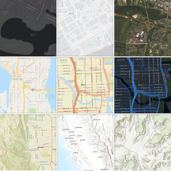
Four main benefits of the Esri Vector Basemaps:
- More frequent data update & shorter release cycle.
See the list below for recently updated areas. Most of these data updates are appearing in the Vector Basemaps several weeks before the same data is available in our online raster basemaps. - Community contributed data available in all styles.
Because Esri creates a single tile set for use in all the vector map styles, most community contributed data not only appears in the vector Topographic map style, but also in Light and Dark Gray Canvas, Street Map, Navigation, etc. - Map styles can be customized by users.
We blogged in the past and will continue to share info in the future how users can customize the Esri vector map styles. There are several tools (beta) that can be used. We have a group of sample vector styles available for you to use and see what can be done to change the look of the map. Sample styles include simple color changes and more involved redesigns utilizing sprite and font changes. -
Better display on high-res devices.
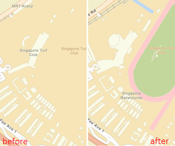
Listed below are areas most recently updated in our Vector Basemaps. Data was from either commercial data or contributions through our Community Maps Program. Locations in bold include screen shot examples.
- Asia Pacific regional updates from HERE
- Central and South America regional updates from HERE
- Aiken County, SC
- Alachua County, FL
- Arlington, TX
- Baltimore City, MD
- Bloomington, IN
- Blue Springs, MO
- Calvert County, MD
- Cecil County, MD
- City of Lincoln/Lancaster County, NE
- Coeur d’Alene, ID
- Corona, CA
- Cupertino, CA
- Dakota County, MN
- Frederick County, MD
- Frisco, TX
- Glendale, AZ
- Grand Junction, CO
- Greater Bridgeport, CT
- Greeley, County
- Greenville, SC
- Horry County, SC
- Hurst, TX
- Jackson County, OR
- Lake County, IL
- Lawrence, KS
- Lewiston, ME
- Loma Linda Univ, CA
- McCall, ID
- Mesa County, CO
- Mesa, AZ
- Montclair State University, NJ
- Montgomery County, MD
- Nacogdoches, TX
- Native American reservations
- Newton, MA
- Oxnard, CA
- Queen Anne’s County, MD
- Redlands, CA
- Rheinland-Pfalz, Germany
- Roseville, CA
- St Marys County MD
- SeaTac, WA
- Singapore
- State of Virginia
- Washington County, WI
Corona, CA in Topographic vector map style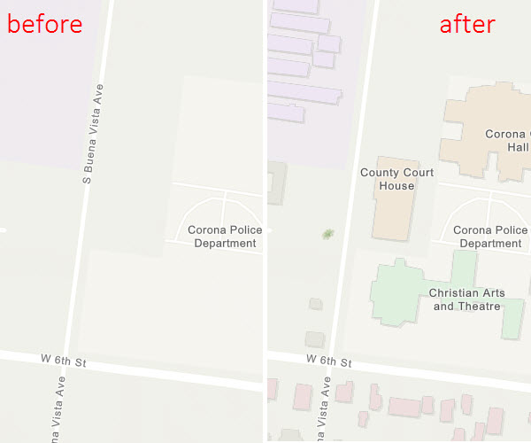
Grand Junction, CO in Street Map at Night vector map style

SeaTac, WA in Navigation vector map style

Singapore in Street vector map style
Stay tuned for more news on the Esri Vector Basemap exit from beta coming in December 2016. Additional information on the next enhancements and new styles will be posted on this ArcGIS.com blog page.


Article Discussion: