Elevation is an essential layer for your work in 3D. ArcGIS comes with a ready-to-use 3D terrain you can combine with your layers in ArcGIS Pro, ArcGIS Online Web Scene Viewer, and ArcGIS Earth. The Terrain 3D layer is the default elevation layer in the apps and is provided at no cost to ArcGIS users.
The latest update to the Terrain 3D layer provides two improvements.
1) New higher resolution terrain for Austria. For the entire country of Austria 3D terrain data are available at 10 meter resolution; a 3x improvement over the SRTM 30 meter data released in June, 2015. The data for Austria are provided through open data sharing policies, which allow all users to gain value through increased access to high quality data.

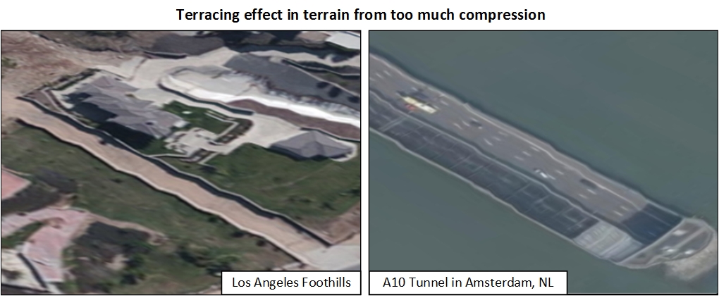
2) We have improved the overall quality of the Terrain 3D layer by adjusting the amount of data compression. Compression of any data is a tradeoff between many variables, mainly quality and file size. Previous releases used too much compression, which resulted in a pronounced terracing effect as seen below.
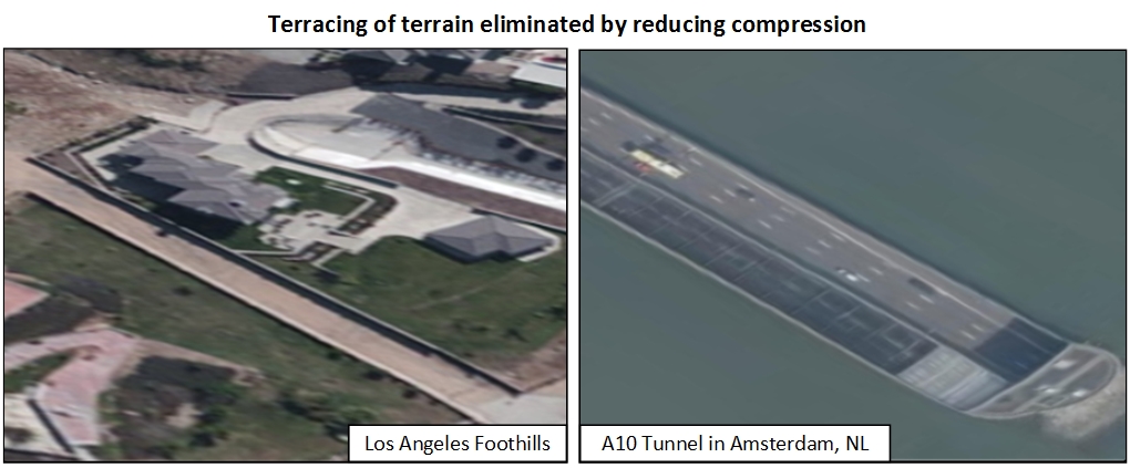
For the latest release we have reduced the amount of compression resulting in a smoother terrain and preserving more of the original data.
For those who want to know more
Terrain 3D is a tiled service that uses the LERC tile format (Limited Error Raster Compression), a data compression algorithm developed by Esri. With the LERC compression format, the user can preserve data integrity by controlling the maximum amount of vertical change when compressing the data. Previous releases of Terrain 3D used a compression value of 0.5 meters, meaning a given elevation raster cell value could vary by as much as 0.5 meters vertically. This resulted in as much as 1 meter of relative error between neighboring cells due to compression.
As a result of this error, visible terracing artifacts appear in some areas of the layer. For this release, we have used a maximum error value of 0.1 meters, where no more than 0.1 meters of difference between uncompressed and compressed elevation values and no more than 0.2 meters of relative error between neighboring cells due to compression. Additionally file size between the two releases did not dramatically increase (Terrain 3D at June 2015 release was 564GB and this release is 612GB). This indicates there is only a small negative impact on file size yet a noticeably better product both in accuracy and visual quality.
If you are interested in using the LERC compression, Esri has recently released the LERC algorithm to open source for use in geospatial applications, available at http://github.com/Esri/LERC
Terrain 3D Background
The Terrain 3D layer is a derivative information product of the World Elevation Service (FAQs). The World Elevation Service provides a comprehensive collection of layers and tools to support your elevation needs. You can find a complete list of available layers and tools here. Additionally you can contribute your authoritative high resolution elevation data through the Community Maps Program – Apply to contribute now. Lastly you can showcase exemplary work by you and others through the Esri Living Atlas. Start by nominating an outstanding map or scene via the Living Atlas Nomination App.

Article Discussion: