What’s new in the Scene Viewer November 2015 Update
The scene viewer is a viewer that allows you to bring your web GIS content into 3D space. Check out the details below to see how you can take advantage of these new features.
Starry Night
We’ve added stars to the scene viewer. The stars you see in the sky in the background will match the correct position for the time configured under the environment settings inside the scene viewer. This is not a layer you will need to add and will automatically show up when you open the scene viewer.
Enhancements to point symbols
In the scene viewer you can now alter the color, size and transparency of the outlines used on your point symbols in the scene viewer. To access the layer properties simply click on the layer name on the left hand pane and this will show you the symbol editor options for your data.
Collaborative workflows
The scene viewer now supports groups that allow group members to update the same items that exist in the group. This will allow group members to edit the same scene. For example group members could add/remove layers, create slides or reorder layers and save the changes back to the original scene. You can read more about those groups here.
Local Scenes
Local scenes are the best way to show your regional or local data in your own projected coordinate system.This is the most exciting enhancement to the scene viewer and I will be covering this in great detail on how to properly setup your data to bring it into local scenes.
In previous releases of the scene viewer you could only display content on a globe. Global scenes show your content and layers in a sphere based on a Web Mercator (Auxiliary Sphere) coordinate system. Having the global scene fixed to a Web Mercator coordinate system restricted cached data (tiled image services, tiled map services and elevation image services) to the Web Mercator projection and to match the AGOL tiling scheme.
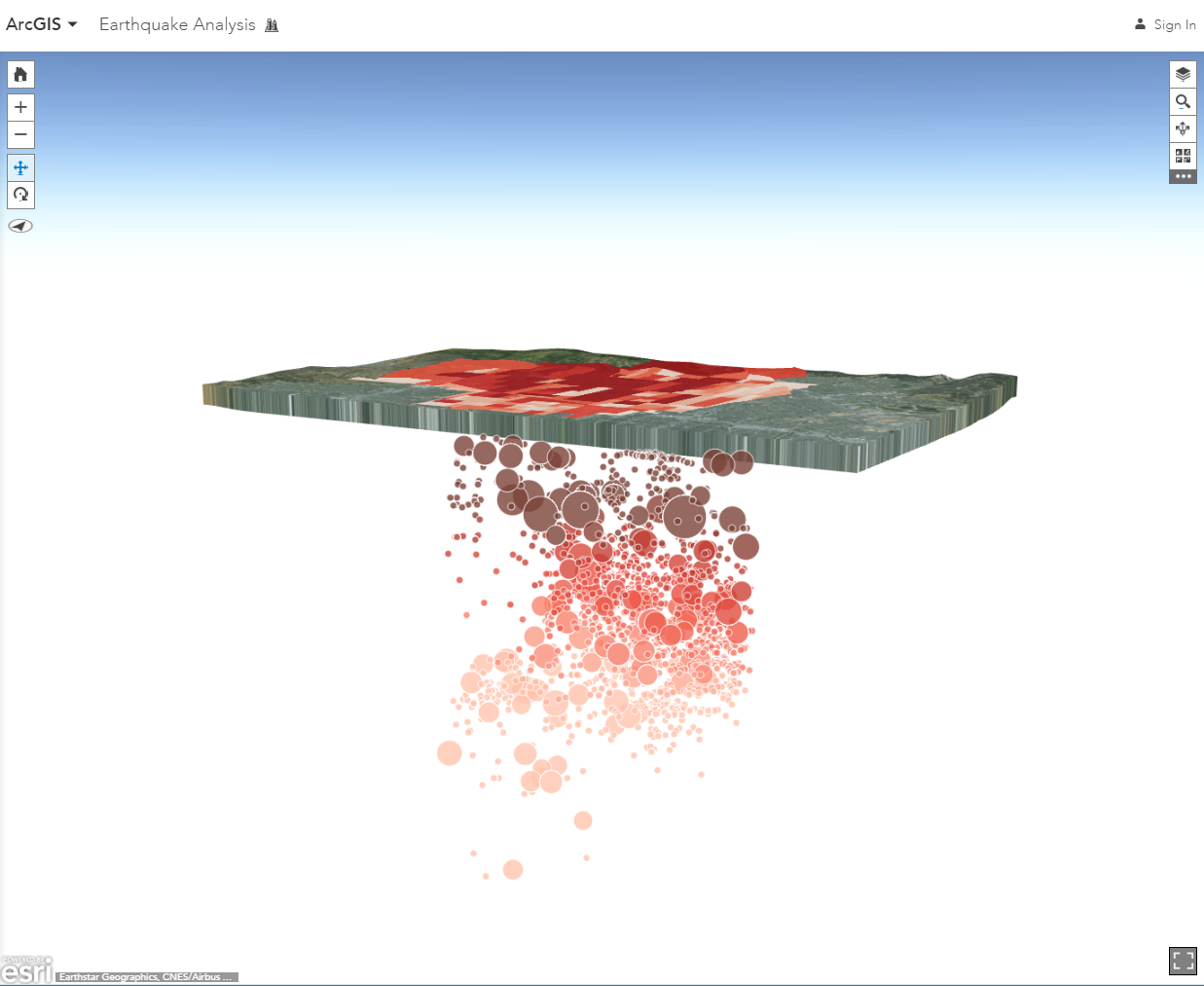
In this release we have brought in the capability to create local scenes. You can use local scenes to view data that is in a different projected coordinate system or is cached with a custom tiling scheme. Local scenes allow you also to set a clipped extent that the layers being displayed in the scene are constrained to. These local scenes are great for viewing buildings on a campus or for viewing subsurface data like earthquake depths, utility networks or pipelines. In this sample below, I am using subsurface earthquake data that is located below my basemap. The local scene makes it very easy to navigate under the surface and look at the recorded earthquake data and how it corresponds to damage at the surface.
So how do you get your data prepped to be used in the scene viewer? Feature layers and dynamic map image layers will work seamlessly in local scenes. However, cached data in a local scene require a few additional steps. . Here are the first things you should to do when creating your cached data is to select the tiling scheme.
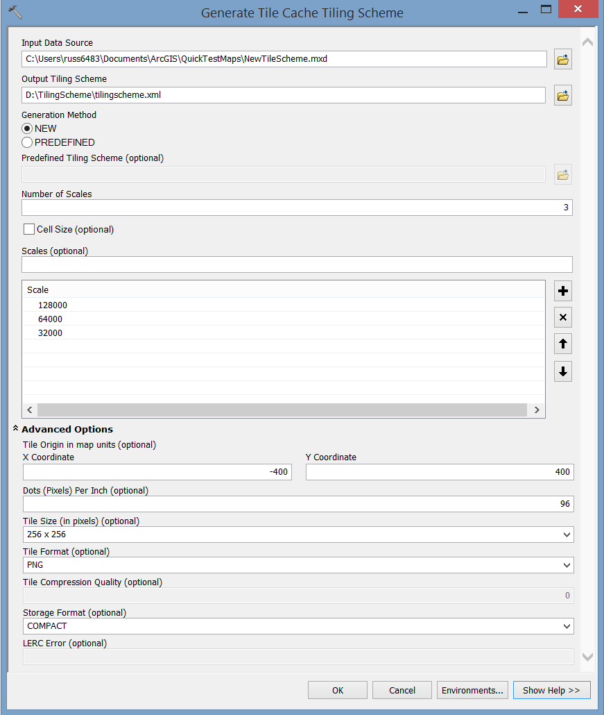
You can create your own tiling scheme file by using the GP tool Generate Tile Cache Tiling Scheme. The tiling scheme includes information on the scale levels, tile dimensions and the tile origin for the cache. The Scene Viewer will support a tiling scheme that has been configured to use 256 x 256 pixel tiles. The scale levels you define within your tiling scheme must increase or decrease by a power of 2. For example if you start your scale at 1:128,000 the next levels should be 1:64,000 and 1:32,000. Note that all decimal values are important and they should be kept without rounding. There are no restrictions on the tiling format or DPI settings.
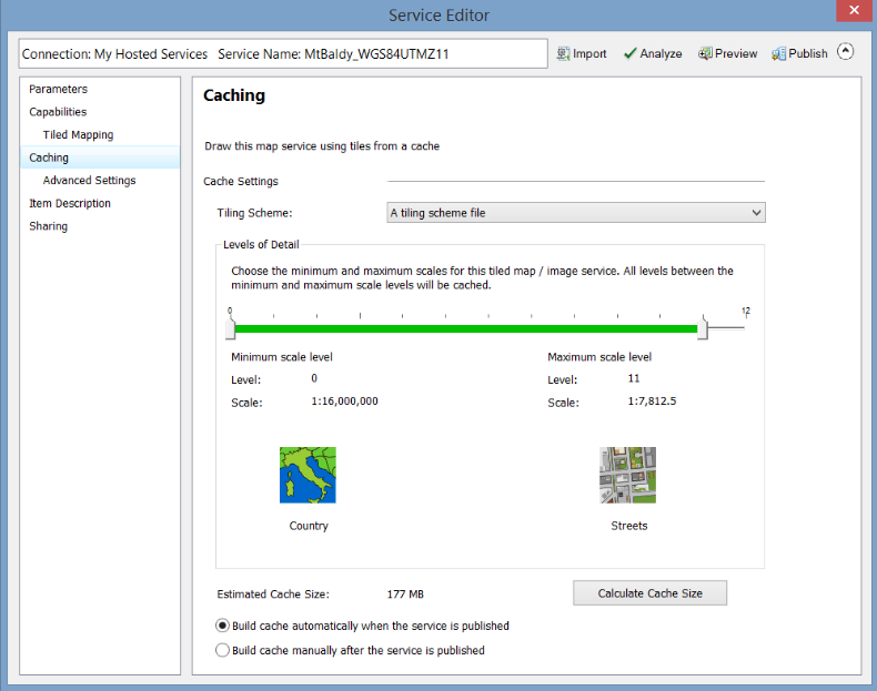
When you are going to generate your cache at the time of publishing your cached service you still have the option to pick a range of Levels of Detail (LOD) within your tiling scheme. Remember to use the same tiling scheme file you generated with the GP tool when publishing your cached map services, cached image services and elevation image services in the Service Editor. When you are cache settings you will choose the “From a tiling scheme” option when you are setting the scales being used. You can then pick the scale range you wish to use for your service and then share the service up to ArcGIS Online or to your ArcGIS Server. Using the same tiling scheme file for all of the cached layers you will use in your web scene is recommend and will help reduce any chance of layers not working with one another. Feature layers you use within the scene viewer do not have to be in the same projection as the cached data. They can be re-projected into the same projection as the cached data.
Once the cached service is ready, the scene viewer can make use it in a local scene. To use your cached data in a local scene, open the scene viewer and on the top right-hand side click on New Scene and choose New Local Scene. This will take your organizations default basemap and instead of having it draped over the globe, it will be flattened to a planar view. When in a new local scene you can switch the basemap to any of the other basemaps in your basemap gallery. After you add any operational layers which could be features layers or cached data the basemap will be locked to the projection the basemap is in and the gallery will be filtered to show only basemaps matching the same projection. Remember the cached layers you plan on adding into a web scene should all have the same projection and tiling scheme. If the first layer you add to a scene has a different projection then the basemap being used in the local scene you will see a prompt that will allow you to drop the basemap being used and the new cached layer will drive the spatial reference of the scene.
You can read more about creating local scenes here. Please leave comments and questions below.
Cheers,
Russ

Article Discussion: