The ArcGIS User Community has provided new content and updates to the Imagery and Topographic Basemaps.
As part of ArcGIS Online, Esri’s Basemaps support a vast GIS community. Thank You to our Contributors and Partners who help support the Living Atlas of the World by providing data and enriching these amazing resources.
This release incorporates new coverage to the World Imagery Map for cities in Canada, and new and updated content in the World Topographic Map for cities, counties and universities in the United States.
Imagery Map Contributor Spotlights
Let’s have a look at our new contributors.
View this tour of the new content in the World Imagery Map.
Some very nice updates as these before and after examples will show.
Corvallis 1:36k to 1:1k (New) (includes communities of Benton County, Albany, Adair, Bailey Branch, and Monroe)
Before
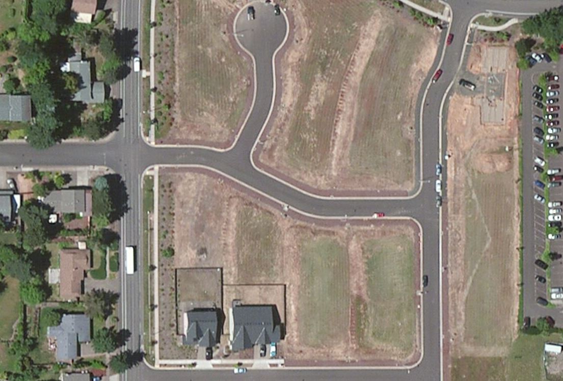
Corvallis 1:36k to 1:1k (New) (includes communities of Benton County, Albany, Adair, Bailey Branch, and Monroe)
After
[iframe width=”600″ height=”400″ frameborder=”0″ scrolling=”no” marginheight=”0″ marginwidth=”0″ title=”Corvallis, OR” src=”http://arcgis-content.maps.arcgis.com/apps/Embed/index.html?webmap=d1e3eaab660b460d8f81153a85d02ded&extent=-123.2585,44.6,-123.2549,44.6016&zoom=true&scale=true&disable_scroll=true&theme=light”]
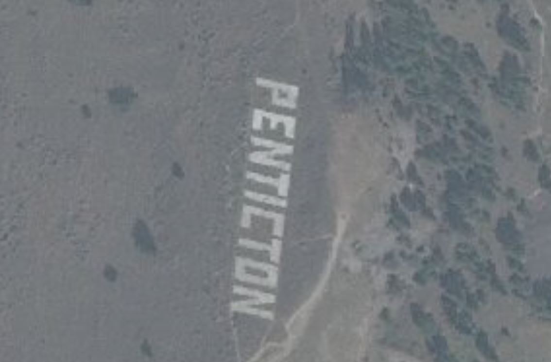
Penticton, BC, Canada 1:36k to1:1k (New)
Before
Penticton, BC, Canada 1:36k to1:1k (New)
After
[iframe width=”600″ height=”400″ frameborder=”0″ scrolling=”no” marginheight=”0″ marginwidth=”0″ title=”Penticton, BC, Canada” src=”http://arcgis-content.maps.arcgis.com/apps/Embed/index.html?webmap=24385dde4d4d477b9e537fdd7e5cd1fd&extent=-119.5759,49.5151,-119.5722,49.5165&zoom=true&scale=true&disable_scroll=true&theme=light”]
Winnipeg, MB, Canada 1:36k to1:1k (New)
Before
Winnipeg, MB, Canada 1:36k to1:1k (New)
After
[iframe width=”600″ height=”400″ frameborder=”0″ scrolling=”no” marginheight=”0″ marginwidth=”0″ title=”Winnipeg, MB, Canada” src=”http://arcgis-content.maps.arcgis.com/apps/Embed/index.html?webmap=f2e67ea815924d5fa2f55ac1de313fc1&extent=-97.1724,49.9674,-97.1687,49.9688&zoom=true&scale=true&disable_scroll=true&theme=light”]
Topographic Map Contributor Spotlights
University of Colorado at Denver and Winfield, Kansas are our newest contributors.
View this tour of the new and updated content in the World Topographic Map.
University of Colorado at Denver 1:9k to 1:1k (New)
[iframe width=”800″ height=”500″ frameborder=”0″ scrolling=”no” marginheight=”0″ marginwidth=”0″ title=”University of Colorado at Denver” src=”http://arcgis-content.maps.arcgis.com/apps/Embed/index.html?webmap=4408cac1b38b42e0881fe9e11c065b6b&extent=-105.0058,39.743,-105.0022,39.7446&zoom=true&scale=true&disable_scroll=true&theme=light”]
Winfield, KS 1:9k to 1:1k (New)
[iframe width=”800″ height=”500″ frameborder=”0″ scrolling=”no” marginheight=”0″ marginwidth=”0″ title=”Winfield, KS” src=”http://arcgis-content.maps.arcgis.com/apps/Embed/index.html?webmap=8cafa939650d44ae8333ef469df877c8&extent=-97.0008,37.2385,-96.9935,37.2419&zoom=true&scale=true&disable_scroll=true&theme=light”]
Living Atlas Community
How do I Use? Combine content from the Living Atlas with your own data. Create powerful new maps and applications!
How do I contribute? Join the growing community of Living Atlas of the World contributors. There are two ways to contribute!
Learn more about the ready-to-use content that is available in the Living Atlas of the World, including how you can contribute your maps and data.
Living Atlas Newsletter: This newsletter will keep you and other members of the Living Atlas user community informed through success stories, examples of applied use, visibility of new content, announcements about events, and other useful resources and information. Subscribe to the Esri News for the Living Atlas Community. You can have the newsletter sent right to your inbox by subscribing here.
Share your story: How has contributing to the Living Atlas Community benefited your organization and community? Has your participation helped meet a particular challenge? Has your applied use of Living Atlas content solved a problem or help meet a goal? Email us at communitymaps@esri.com so we can promote your success.
Feedback
If you have previously used the World_Topo_Map or World_Imagery, you may need to clear your cache in order to see the updates.
If you have feedback on content, try our Topographic Map Feedback web map or Imagery Map Feedback web map.
If you have other feedback or comments, please post them to the ArcGIS Online Discussion Group and the Living Atlas Discussion Group on GeoNet.


Article Discussion: