 Esri’s hosted content on ArcGIS Online now includes five new layers to use in your water resources maps and analyses.
- USA National Hydrography Dataset – High Resolution (USGS)
- USA Watershed Boundary Dataset (USGS)
- USA Polluted Waters (EPA)
- USA Polluted Waters – Heavy Metals (EPA)
- USA National Hydrography Dataset Plus Version 2.1 – Seamless Vector Denormalized (USGS)
To use these services, you can either add them to your ArcGIS Online (AGOL) map directly from their respective AGOL content item or make a direct connection to the landscape1.arcgis.com server in ArcMap (Add ArcGIS Server connection).
Details of each service
The High Resolution National Hydrography Dataset displays key features of the United States’ surface water drainage network including streams, lakes, waterfalls, gauging stations, wells and sinks. The High Resolution dataset was created at a scale of 1:24,000 (one inch on the map equals 2,000 feet on the ground), which differs from the Medium Resolution NHD, which was created at a scale of 1:100,000. While both the High Resolution NHD and the Medium Resolution NHD are constantly being updated by stewards of the NHD program, the data used to create these layers was taken from the March of 2015 version of the NHD.
The Watershed Boundary Dataset is the authoritative source of surface water drainage area boundaries across the United States. The boundaries are defined by hydrologic and topographic criteria that delineate an area of land upstream from a specific point on a river and are determined solely upon science based hydrologic principles. Administrative boundaries, special projects or particular programs or agencys are not considered for the delineation of these watersheds. The watershed is often used as the minimum unit of areal measurement in terrain/landscape and/or hydrology applications, and thus is a very important starting point for many GIS analyses.
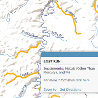
The updated Polluted Waters and Polluted Waters – Heavy Metals layers display water bodies listed as impaired under Section 303(d) of the Clean Water Act, and are defined as waters that are too polluted or otherwise degraded to support their potential or existing uses. This designation takes into consideration 34 different impairment types, which can be used to filter the dataset. The Polluted Waters – Heavy Metals layer has a filter applied to only show waters impaired by Mercury and heavy metals.
Finally, the updated National Hydrography Dataset Plus V2.1 – Seamless Vector Denormalized layer is a dataset released by the USGS in support of the Open Water Data Initiative (OWDI). The ODWI integrates fragmented water information into a connected, national water data framework to support use cases like the National Flood Interoperability Experiment (NFIE), water supply decision support systems, and spill response/water quality issues. The updated NHDPlusV2.1 Seamless dataset is based upon the Medium Resolution NHD (1:100,000 scale) and is one seamless dataset for all of the United States with NHDPlus attribution present in the flowlines attribute table. Previous versions of the NHDPlus were only available to download by separate drainage basins and required table joins to liberate the Plus attributes.
For more information about the ODWI and NFIE, please join us on Sunday, July 19, 2015 for the Esri Water Resources Meeting at the San Diego Convention Center (register here for free!)
To explore the water resources layers mentioned above, and other water resources layers hosted by Esri, visit our Landscape Layers group on ArcGIS Online or peruse the Living Atlas Gallery.


Article Discussion: