By Tamara Yoder, Data Content ArcGIS Online
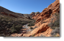 Hiking in Las Vegas, Nevada, can be a dangerous undertaking overall; with hot, arid climate and rugged terrain, hikers need to be cautious. Over one million hikers visit Red Rock Canyon National Conservation Area per year. ArcGIS will be used to educate the general public about the relative difficulties of the park’s trails in a web app on kiosk computers in the visitor’s center. Trails are symbolized on the map by difficulty and users can click on trails to see pop-ups with additional information. Users can also create an elevation profile for any trail they select. The elevation profile shows a two-dimensional, cross-sectional view of the landscape that the trail traverses.
In the new Hiking Red Rock Canyon project on the Learn ArcGIS web site, you’ll learn how to make that web app. Using layers from Esri’s Living Atlas of the World, you’ll create the web map and configure the pop-ups. Then you’ll use the configurable Elevation Profile web app template to add the profile functionality to the interface.
Platform: ArcGIS Online
Time: 1 hour
Level: Beginner
Build skills in these areas:
- Adding layers to a map
- Changing map symbols
- Configuring pop-ups
- Sharing a map as a web app
- Using the Elevation Profile web app template

Article Discussion: