Version 3.13 of the ArcGIS API for JavaScript is now available! Below is an overview of the release including new features, enhancements, and changes included in version 3.13. For a complete list with API enhancements and bug fixes, check out the What’s New in 3.13 page on the developers web site.
Smart Mapping
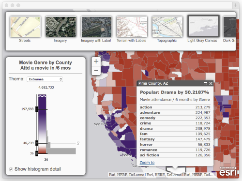
The new Smart Mapping capability introduced in the March 2015 update of ArcGIS Online is also a big part of the 3.13 release of the JavaScript API. Smart Mapping is a new approach that both developers and users of the ArcGIS platform will be able to leverage for making maps that are useful and visually stunning. For more information on Smart Mapping see the Introducing Smart Mapping blog article, Smart Mapping video on esritv, API Reference, and sample below.
- esri/renderers/smartMapping module
- FeatureLayerStatistics plugin
- Related Smart Mapping slider widgets
Geometry Engine
A new synchronous and asynchronous client-side geometry engine is part of this release. There are over 30 different methods for performing operations that previously would have required a round-trip to a server. For more information on the these new modules, follow the previous links. Note: These features are currently in beta.
require([
  "esri/geometry/Point",
  "esri/geometry/geometryEngine",
  "esri/SpatialReference"
], function (Point, geometryEngine, SpatialReference){
  var pt1 = new Point(-118.15, 33.80, new SpatialReference({wkid: 4326}));
  var pt2 = new Point(-119.15, 32.80, new SpatialReference({wkid: 4326}));

  // Using Module to Union
  var union = geometryEngine.union([pt1, pt2]);
  console.log("geometryEngine.union: %o", union);
});
Search Widget
The Search Widget new at version 3.13 has been designed to provide a single searching and suggestion experience. It allows you to search across multiple Locator and Feature Layer services from a simple interface.

For more information, see the Working with the Search Widget topic and the Search Widget API reference, in addition to these samples:
- Search – Basic
- Search – multiple sources
- Search – with customization
- Search – without user interface
Image enhancements
Two new classes Image Service Vector Layer and RasterLayer have been added at this release enhancing ImageServer functionality. The ArcGISImageServiceVectorLayer provides functionality to display image pixel values as vector point symbols, and RasterLayer provides capabilities to perform client-side pixel filtering. For more information see the API Reference on RasterLayer, ArcGISImageServiceVectorLayer and Image Layers samples.
Additional enhancements
- New widgets and styles to support Smart Mapping
- New FeatureLayerStatistics plugin and smartMapping module
- New caching property and methods on Geometry
- New analysis widget samples: Calculate Travel Time, Viewshed Analysis, Watershed Analysis
- Directions widget improvements
- New busyIndicator widget to support UI feedback
- Support for Greek locale
- Various bug fixes and enhancements
TypeScript definition file updated
- We’ve updated the TypeScript definition file in the jsapi-resource repo. Note that the file name has changed to arcgis-js-api.d.ts.
Dojo
Version 3.13 of the ArcGIS API for JavaScript uses Dojo 1.10.4. dgrid version 0.3.17. put-selector version 0.3.6 and xstyle version 0.1.3 are also included.


Commenting is not enabled for this article.