The National Geospatial-Intelligence Agency (NGA) has released an advisory notice on the use of the Web Mercator coordinate system in military and intelligence applications. In the advisory, NGA warns about positional accuracy issues with Web Mercator, especially at higher latitudes, and “…reminds the community to use DoD approved World Geodetic System 1984 (WGS 84) applications for all mission critical activities.”
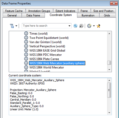 Web Mercator, called “WGS 1984 Web Mercator (auxiliary sphere)” in ArcGIS, and also known as “EPSG: 3857” (European Petroleum Survey Group) and “WGS 84/Popular Visualisation Pseudo-Mercator”, was popularized by Google and has become the most commonly-used coordinate system for web mapping applications. It is currently used by Google Maps, Bing Maps, and Esri ArcGIS Online basemaps, among others.
The accuracy issues that the NGA warns about are due to the Web Mercator coordinate system’s simplified representation of the Earth as a sphere. Because the Earth is actually flattened toward the poles (ellipsoidal), the positional accuracy of latitudes in Web Mercator decline with distance away from the equator, relative to an ellipsoidal projection. In ArcGIS this is not likely to cause problems unless data in Web Mercator has its coordinate system inadvertently described as being in an ellipsoidal Mercator version such as “World Mercator” (EPSG: 3395), or vice versa. Another issue that is more likely to apply in ArcGIS is that Web Mercator suffers from the drawback shared by other Mercator projections of scale distortion near the poles.
Fortunately, ArcGIS supports and can project data between many different coordinate systems, including Web Mercator and true WGS84 coordinate systems such as Geographic WGS84 and UTM WGS84. Applications built with ArcGIS that use the Web Mercator coordinate system can project feature geometries to a more appropriate coordinate system for measuring areas, distances, or coordinate locations. Operational layers used with Web Mercator basemaps can be stored in other coordinate systems, and projected on the fly to match. ArcGIS for Desktop will project multiple data layers with different coordinate systems on the fly to make them line up with the coordinate system of the map’s data frame. Although it is possible to edit data that is in a different coordinate system from the data frame, when high levels of accuracy are critical, it is better to project the data to a common coordinate system before editing.
Although Web Mercator is used in the civilian ArcGIS Online basemaps, military and intelligence organizations can use ArcGIS for Server to publish map services and basemaps on their own secure networks using any WGS84-based coordinate system. For information on building basemaps for military and intelligence use, see the Solutions pages. The coordinate system of the publishing basemap and the tiling scheme for the cached map service can be set to either the Geographic WGS84 or UTM WGS84 coordinate system, and the resulting basemaps will be in that coordinate system, rather than Web Mercator.
Administrators can set up Portal for ArcGIS or ArcGIS Online for Organizations to use these internally published basemaps instead of the default ArcGIS Online Web Mercator basemaps. Alternatively, such organizations can use the Commercial Joint Mapping Toolkit (CJMTK) Geospatial Appliance (CGA) for basemaps. Basemaps in the CGA are stored using the Geographic WGS84 coordinate system. Existing maps can be set to use a new basemap, and their data frames set to use a new coordinate system. Web applications and mobile apps (such as Squad Leader and Vehicle Commander) can be configured by editing the mapconfig.xml file to consume these alternative basemaps and tile packages in WGS84-based coordinate systems.
If you have existing templates that you want to use in an NGA-approved coordinate system, you can substitute a new basemap, change the data frame coordinate system, and project the feature classes to a new coordinate system or use your own (already projected) feature classes.
To project data in ArcGIS for Desktop, use the Project (Data Management) geoprocessing tool to project feature classes, and the Project Raster (Data Management) geoprocessing tool to project rasters. If you need to project multiple feature classes, you can use the Batch Project (Data Management) geoprocessing tool. Do not use the Define Projection (Data Management) tool for this purpose; this tool only changes the description of a feature class’s coordinate system, it does not actually project the data. See this Esri Support Services blog postfor more info on when to use Define Projection.
Going forward, Esri ArcGIS for the Military and ArcGIS for Intelligence Solutions will use Geographic WGS84 or UTM WGS84 coordinate systems in maps and templates to conform to the NGA guidance. Many of our previously-released templates use Web Mercator, but these will be projected to WGS84-based systems as future versions are released.
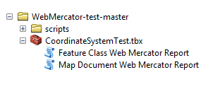 This GitHub repo has a toolbox and two Python tools that you can use to check a directory for feature classes or maps that use the Web Mercator coordinate system.

Commenting is not enabled for this article.