With the 10.2.2 release of Collector for ArcGIS in March you will be able to use maps on your smartphone or tablet when disconnected from the network. We started blogging about this last month by discussing how you will be able to download maps to your device. In this article we want to discuss feature services, the flow of data, and synchronizing edits.
Feature Services and Disconnected Use
In the last article we briefly touched on the composition of a map and the fact that the GIS features you collect and update with Collector are managed using a Feature Service. Collector supports use of both Hosted Feature Services that are stored within a managed database inside of your ArcGIS organization as well as on-premises Feature Services that are stored locally within your enterprise geodatabase and published via ArcGIS Server.
Feature Services provide the capability to disconnect feature data and synchronize changes between the field and office as well. There are a number of things you need to do to prepare your data for disconnected use with feature services.
The workflow from preparing your data to synchronizing changes is best explained using the graphic below. It is important to note that you DO NOT need to publish your data to the cloud. As mentioned above you can use your own on-premises feature services and manage all of your content behind your firewall. Publishing directly against your enterprise geodatabase you will need to consider using either a VPN tunnel to access those services for download/sync or you can use the web adapter to provide access to remote clients.

Feature Services provide a new operation called Sync. If you want to work disconnected with Collector, you will need to enable the Sync operation on your feature services. Sync provides the ability to download a copy of data to your device as well as synchronize changes when connected. With ArcGIS Server, this is accomplished using a new SyncTools Geoprocessing Service. This service is installed with ArcGIS Server and must be up and running at all times. If you are using Hosted Feature Services within ArcGIS Online, this is managed for you.
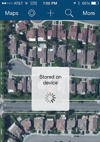
Downloading a map to your device creates a copy of data for the area you have chosen to take offline. The copy itself is a replica that is created and managed by the Collector app. It is important that you do not erroneously delete replicas from your feature service – let the Collector handle them for you. Within the context of Collector, the replica is unique to the device you download from and all synchronization will occur from the device that created the replica. In a future release, Collector will support pre-caching and provisioning of replicas.
Map Schemas and Managing Change
If you have used the Collector in the past, or any Esri mobile product for that matter, you know that the user experience for collection and editing is bound to the map and it’s schema. Making maps for field collection, you also know that you will never get the map schema right the first time. Knowing this and knowing that you will have disconnected field workers – understanding/managing the impact of an evolving schema is important.
Let’s consider hosted feature services first. Hosted feature services are a physical copy of your data and solely managed through the service/service item itself. If you need to make a schema change (add a field or a domain value for example) then you will need to re-publish services again (overwrite your existing service) as you cannot edit the schema of a hosted feature service. If you have disconnected field clients and/or edits that are in that service already, then you will need to plan for this change as you will be deleting the service they created replicas from and you do NOT want to lose edits – so sync up and export changes first! Also if you have additional reference feature layers that you will be taking to the field, it is recommended that you publish them as a separate feature service – no point in having to republish them each time – the map you take to the field can support layers from multiple feature services.
Now let’s consider feature services published using ArcGIS Server. These services reference feature layers within your enterprise geodatabase. To change the schema, you can simply stop the service, modify fields/domains, etc and start the service again. But what happens to all the disconnected field clients? Their schema is now obsolete! Actually not to worry. The sync process will still synchronize with the service (so long as you did not delete the feature layer itself!). You can add a field, remove a field, add/remove a domain value if you like. The replica is founded on an old schema but both the replica and the service can manage the change. Remember that the disconnected client is ALWAYS working with the schema version from the point in time of “downloading the map”. To take advantage of the changes you make they will need to go into the manage experience on their device and remove features from the device. This will delete the replica and they can download a fresh schema for the area they are working in.
Regardless of Hosted or On-premises feature services, you will want to take extra care in managing changes across an evolving schema.
Local Edits and Synchronizing Changes
Once downloaded, maps on your device can be opened and you can edit existing GIS features or collect new features just as you can with maps you open from the Cloud. What is different is that a local map works in a fully disconnected mode – meaning that it will only draw content stored on the device, it will only show you popups from local feature data, and when you collect new features or edit existing ones that all of the edits are stored locally on the device itself.
Synchronization itself is a manual process. You will need to exit the map and tap the Sync button on the map card to sync changes when you have connectivity. It is important to note that the synchronization is bi-directional. You will receive all changes that others have made inside of the area you downloaded to your device when you sync.
 Manage Maps On Device
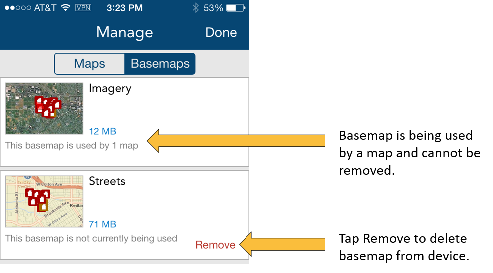
You can manage the maps that are downloaded to your device within the Collector app. Local content is organized into both Maps and Basemaps from a management context and you can see this by tapping Manage from the Action button. From the Manage page you can view when maps were downloaded/sync’d, how much size they are taking on the device and remove them. Removing feature content from the device will delete local replicas and un-register any replicas it created on the feature service as well.
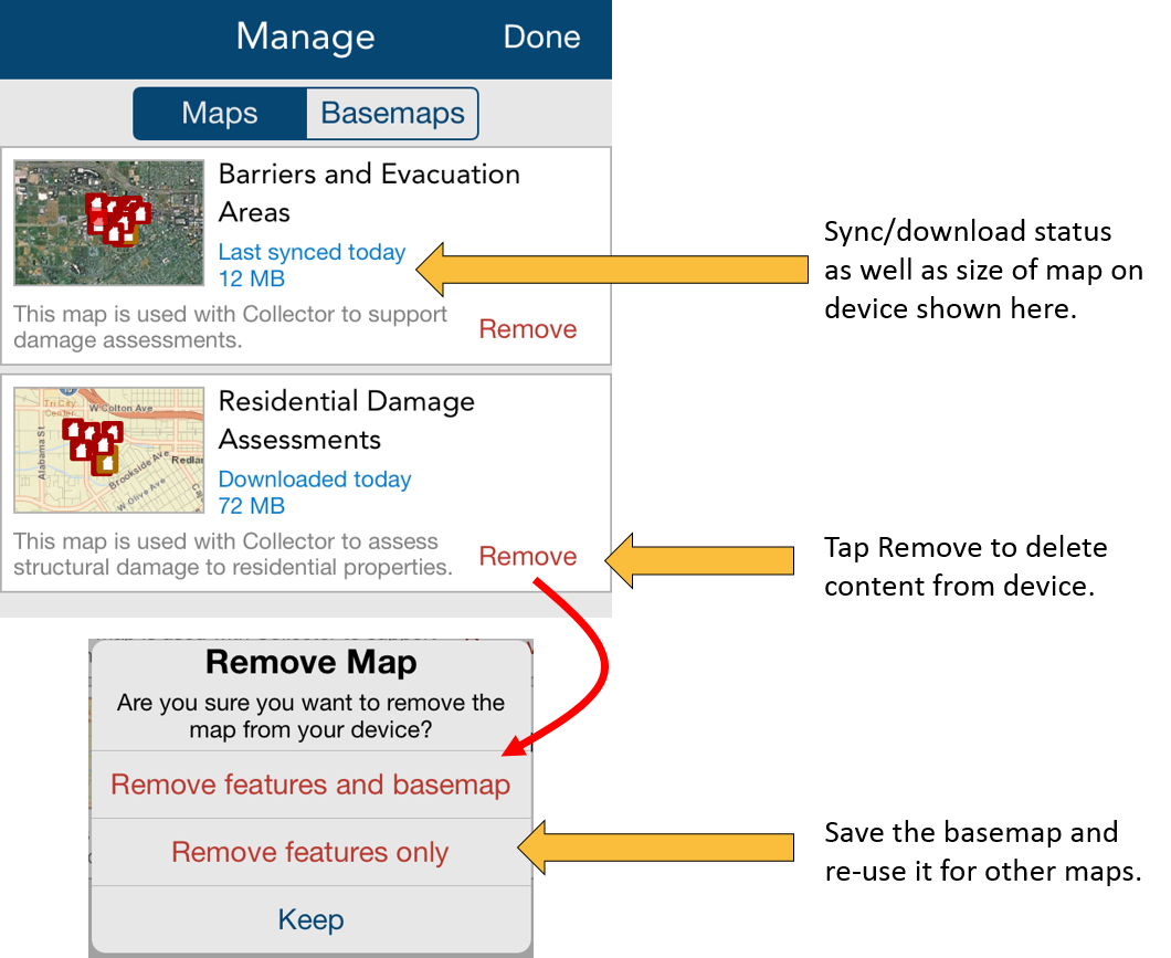
Basemaps are tiled map service layers, tend to be rather large, and take time to extract/download to your device. Collector lets you re-use basemaps that you download to your device and so you can manage them separate of the map itself.
 As mentioned in the previous post, you can either extract basemaps referenced in the map you authored within your ArcGIS organization or you can side-load basemaps directly to the device. We will discuss this in another blog article.
Summary
A lot of content was covered in this article and there are some key takeaways that we hope you think about/plan for as disconnected editing comes to smartphone and tablet devices:
- You can use on-premises or hosted feature services to manage the data that you collect/update in the field. Each have their benefits/challenges. If using on-premises feature services, make sure to prepare your data and services.
- Consider the implications of disconnected clients when changing map schema’s so you keep everyone up to date.
- You can manage maps on devices. Consider the use, re-use, and deployment of basemaps. They often constitute the largest volume of data you work with.
- Plan your field deployments and updates carefully. Think about download once and sync many times as a key workflow.
The Collector team is working hard to finish these capabilities now and release in March. We look forward to your feedback!!


Commenting is not enabled for this article.