The Australian Hydrological Geospatial Fabric (GeoFabric) is the foundation of the Australian Water Resources Information System (AWRIS), developed by Australia’s Bureau of Meteorology as a spatial framework for discovery, query, reporting and modeling of water information. AWRIS is an effort mandated by the Australian Government to help enhance the understanding and management of Australia’s water resources. The GeoFabric provides a modular conceptual model that connects input datasets and products for analysis based on:
- combinations of data products at different spatial and temporal resolutions,
- different feature representations from a single maintenance environment which allows you to model how water is stored, transported and used through the landscape.
The key to the GeoFabric that makes it unique, versatile and robust, is
The underlying infrastructure of the Geofabric is a set of points, also called ‘contracted nodes’, that represent known features in the landscape such as the confluence of two major rivers, river outlets, inland sinks and water body inflow and outflow points.
…Each contracted node feature has an associated ‘contracted catchment’. Contracted nodes are linked together into a node-link network (Australian Hydrologic Geospatial Fabric Product Guide, 2011).
These points have a permanent identifier present in all versions of the Geofabric, thus providing a framework through space and time.
It’s the node-links that connect the system together, and relate the system components: Surface Cartography, Surface Flow Network, Surface Catchments, Groundwater Cartography, Hydrology Reporting Catchments, and Hydrology Reporting Regions. Elevation data, the derived digital terrain models with their derivative, and the surface water features are connected in an integrated system that allow analysis and modeling, as well as cartographic quality display of the results.
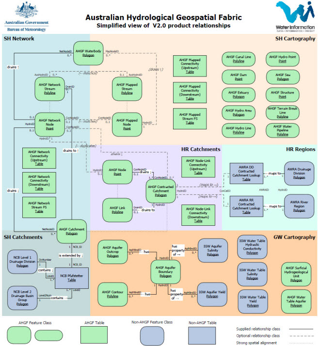
The GeoFabric is an exemplary hydro GIS, which continues to be enhanced, and Version 2.0 was released in November.
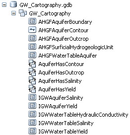
The new component in Version 2.0 is Groundwater Cartography. Groundwater Cartography is a geodatabase that contains Feature Classes that include information about aquifer boundaries, types, and contours, as well as information about the groundwater like hydraulic conductivity and salinity.
The Bureau has a wealth of information about the GeoFabric on their website, including documentation for each GeoFabric product. Their product tutorials are going to be updated as well (coming in the next few months).
Check back to the Hydro Blog for additional updates.
Thanks to Caitlin Scopel and Erika Boghici for providing this post. Questions: cscopel@esri.com.


Commenting is not enabled for this article.