ArcGIS 10 Service Pack 2 includes the new Continue Feature tool. Continue Feature allows me to resume digitizing an existing feature so its shape can be updated by sketching. For example, I can use Continue Feature to extend a line or add a part to a multipart feature by updating a feature’s edit sketch. These workflows were not originally available in ArcGIS 10 and required installing an Esri code sample to perform. However, they have been reincorporated and are now built into the software with the introduction of the Continue Feature tool.
Once I install ArcGIS 10 SP2, I need to add the Continue Feature tool to a toolbar from the Customize dialog box since it is not on the ArcMap interface by default. I click the Customize menu > Customize Mode, drag Continue Feature from the Commands tab, and drop it onto a toolbar. I can put it on any toolbar I want, but I like to add it to the Edit Vertices toolbar. This toolbar appears automatically when I am editing the shapes of features with the Edit tool, which is when I will be using Continue Feature.

Extending a line by sketching
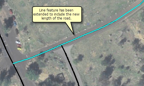
One of the most common workflows I can accomplish with Continue Feature is to extend a line by adding new segments from the last vertex at the end of the existing sketch. Previously, in ArcGIS 10, I either needed to use the Esri code sample or create a new line and merge it with the existing one. Now, I can easily do this with Continue Feature.
I have a roads layer that needs to be updated to include a newly built portion. To extend the line, I double-click it with the Edit tool and click Continue Feature. When I do this, I see that the sketch is reversed from the direction I need to extend it. Right now, the last vertex in the sketch (shown in red) is actually at the location that should be the start point of the line when extended. I can right-click directly over the sketch and click Flip to change the line’s direction so I can digitize in the proper direction.
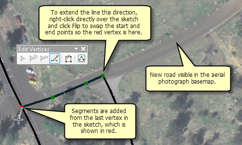
Similar to creating a new feature, I have access to any available sketch construction methods on the Feature Construction mini toolbar. These segments only need to be straight, but I could create the line with curves or by tracing it from the shapes of other features. I also can use keyboard shortcuts or right-click to access a menu of commands to help place vertices in the sketch. I need to finish the sketch when I am done digitizing the additional segments. Any attributes from the original feature are maintained in the updated feature.
Adding a part to a multipart feature
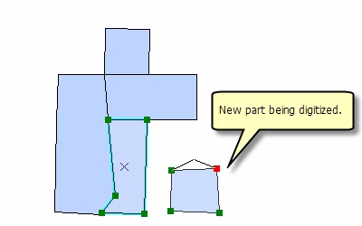
Continue Feature allows me to add a part to an existing feature to create a multipart polygon, line, or point (multipoint) feature. A multipart feature contains more than one part on the map but references one row in the attribute table. I have a layer containing wildlife habitats that needs a new zone added to it. This habitat should be represented as a multipart feature since it contains polygons that are geographically separated but have the same ID and ecological characteristics. I can use Continue Feature to digitize the new part without having to create a new feature and merge it with the existing one.
As with extending lines, I use the Edit tool to double-click the habitat polygon and click Continue Feature. When I am creating polygons or adding points to a multipoint feature, I just begin digitizing the new part. To create multipart lines or add even more parts to the polygon, I can right-click, click Finish Part, then continue digitizing the parts. I can also hold down the SHIFT key and double-click the last vertex as a shortcut to finishing the part.
I can now sketch the shape of the new part using any available construction method or shortcut. In this case, the coordinates of the habitat corners were obtained from a GPS track, so I can use absolute x,y to enter the vertices. When I am done, I finish the sketch to update the feature’s shape and make it a multipart feature. The original habitat zone’s attribute values are preserved and associated with both parts of the feature.
For more information about the Continue Feature tool, see Extending a line by sketching and Adding a part to a multipart feature in the ArcGIS Desktop Help.
Content provided by Rhonda from the Editing Team

Commenting is not enabled for this article.