Hydro is not only for surface water — the publicly available Arc Hydro Groundwater data model helps you archive, display, and analyze multidimensional hydrogeologic data, and better manage your groundwater and subsurface data within ArcGIS.
Tools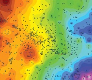 are also available to help implement the data model.
Aquaveo, a water resources engineering consulting firm, and an Esri business partner, architected the Arc Hydro Groundwater tools, which are broken into three toolsets: Groundwater Analyst, MODFLOW Analyst, and Subsurface Analyst. 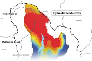
These tools enable you to plot time series and make flow direction maps, create, archive and visualize MODFLOW models, and create and visualize both 2D and 3D geologic models.
The latest version of Arc Hydro Groundwater (as well as a free trial download) is found on Aquaveo’s-Arc Hydro Groundwater website, and tutorials for each toolset are provided for free in the Hydro Resource Center Education Gallery.
For more information on Arc Hydro Groundwater check out the Hydro Resource Center’s Groundwater page and Aquaveo’s Arc Hydro Groundwater Wiki.
Key members of the Arc Hydro Groundwater team will be blogging often, so check back to find the latest developments with the Arc Hydro Groundwater data model and tools, and to hear valuable perspectives and implementations of Arc Hydro Groundwater.
Special thanks to Caitlin Scopel for providing the post. Questions for Caitlin: CScopel@esri.com.


Article Discussion: