What role do you expect a base map to play in your GIS?
Some say, “The base map is the part of the map I don’t have to make.” To that, I say, who should make it, who will use it, and what will they do with it?
Today a wide variety and diversity of base maps are proliferating with emerging Internet technologies such as mash-ups on Google Earth, ArcWeb Services, your own ArcGIS Server maps, etc. Our intent is to consider, or depending on your perspective reconsider, the functionalities that a base map, particularly a GIS base map should have. Are all these new base maps what you need?
Should or has role of a base map evolved? If so, is it a lasting change or is change the only constant in the world of GIS base maps?
Are there different kinds of base maps? For instance it’s not a big stretch to see that demographic and topographic base maps are useful as cartographic base maps. What other kinds of maps do you map that need yet a different sort of base map?
A geocode-able street centerline dataset and a terrain dataset serve essential functional roles in a GIS base map and also support the creation of other data and map products. Are there other fundamental datasets you rely on?
These are all questions that warrant discussion. We at Esri would like to get your perspective; answer any of the questions posed, or pose your own.


High res ortho-rectified imagery makes a good base.
To make these more successfull ESRI may want to consider removing the log in aspect of the blog.
Who want’s to log in to make a comment on a blog?
I only say this becuase this is a great blog you’ve started, and it’s a shame to let it go inactive due to a silly login requirement.
Posted by Brian (10.35.26.11) on June 08, 2007 at 06:04 AM PDT #
About the log in: having people log in to post can sometimes be a drag. However, for a majority of the major web blogs out there (big and small), registration is required and a lot of times for one reason: spam. By ensuring that the users must log in to comment, they ensure that all the comment-bots that roam the internet can’t post internet poker and mortgage related comments.
Though I will suggest to our folks responsible for web security that we look into ways to add a service to auto-log you in once you’ve asked for that service.
Posted by Charlie Frye on June 08, 2007 at 01:39 PM PDT #
OK, so what do we mean by Base Map? In the UK Ordnance Survey’s raster data (currently 1:250k, 1:50k, 1:25k and 1:10k) is increasingly being used as the background for the addition of application specific data (e.g gas lines, accident sites, pubs etc etc) Is this what is meant?
We are looking at ways of improving the range of raster supplied (currently it is effectively a scan of an existing paper product)We have translated 1:250k data into ArcGIS and by buidling up the data themes that make the map we also have the option of turning them off for data supply (e.g public utilities probably do not require tourist symbols)
We have created a style sheet, and layer set, that generates the current raster product, should we be creating alternative style sheets for the customer that swtich the priorities for the data being presented, or even change the way the map looks?
Or – By Base Map do we mean the core data that is being used, for instance, road centre lines, buildings (to a variety of generalisations), water networks. And can the data be manipulated by the user or is it ‘fixed’.
Ordnance Survey already has a number of datasets that can supply core data, but is there anything we are not supplying?
Posted by John Dancy on June 13, 2007 at 01:19 AM PDT #
On John’s question, I mean both kinds of base maps–it’s actually tricky question to frame. So feel free to comment on either or compare and contrast. Another angle would be: what do you think your customers really want or find most useful? Most of us who have to work with base maps get our jobs done, but it would be good to know the ideas or qualities that would make for better base maps.
Posted by Charlie Frye on June 13, 2007 at 03:35 PM PDT #
I just noticed on Brian’s comment, he, I assume purposefully left off map when he said, “High res ortho-rectified imagery makes a good base.” I’ve always considered such imagery a layer in the basemap rather than the base map itself. Imagery with out proper context is just a pretty picture, and context comes from the rest of the base map, like the names of other features. Though as I was reading Jerry Dobson’s article in the latest ArcNews, I was realizing that the folks he eschews for not recognizing problems as being geographic are the same folks that I see (typically) thinking or believing hi-res imagery is enough in terms of being a base map. I guess I don’t think base maps can be defined in terms of half-measures or partial sets of information layers.
Posted by Charlie Frye on June 13, 2007 at 03:46 PM PDT #
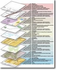
I was wondering where we could find a larger version of that “BaseMapDataModelStack.gif” found in your original post. I thought that might be helpful to look at when giving the topic of ‘basemaps’ a thought.. Could you point us in the right direction to get our hands on that image?
Posted by Ian Bruce on July 13, 2007 at 10:21 AM PDT #