Last Update: December 10, 2015
In early January of 2014, we heard quite a bit about the polar vortex (not a new term, by the way) as North America struggled with some of the most frigid and dangerous temperatures seen in a long time. It is through the power of Earth observation from satellites, aircraft, ships, and other platforms that it was possible to track and learn about this important event, and its implication for our safety and economy.
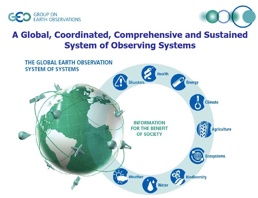
One of the most comprehensive efforts in place to monitor the entire face of the Earth is a group of over 140 governments and leading international organizations that is seeking to establish a fully functioning Global Earth Observation System of Systems (GEOSS) by 2015.
In 2003, an initial group of 33 countries, including the G8, convened at the Johannesburg Summit on Sustainable Development. These government ministers (NOT scientists) were able to recognize a growing and critical need for improved, near-simultaneous observing of the entire planet, and developed a plan for a more coordinated Earth observing system. The Group on Earth Observation (GEO) was established in February 2005 after this summit, and has now grown to a membership of 89 governments working in concert with 67 participating organizations, including those familiar to our GIS community such as the GSDI, the OGC (of which Esri is a member), the European Environment Agency, and UNESCO. The GEO Secretariat (currently led by Barbara Ryan), plays a leading role in coordinating and supporting a series of work plans for implementing GEOSS, which itself is based mainly on satellites, but also includes a network of environmental sensors on land, in freshwater lakes and streams, and, to a growing extent, in the lower atmosphere and the oceans.
GEOSS seeks to address 9 societal benefit areas for Earth observations to address: disasters, health, energy, climate, agriculture, ecosystems, biodiversity, water, and weather. As governments and their partners continue to monitor the face of the Earth, the collection, storage, analysis, and sharing of these observations remain fragmented, incomplete, or redundant. Major observational gaps also remain (particularly as we seek to look beneath the surface of the land and the water). As such, GEO’s credo is that “decision makers need a global, coordinated, comprehensive, and sustained system of observing systems.”
Esri has millions of GIS and imagery users in hundreds of thousands of organizations around the world that work in the aforementioned GEO societal benefit areas. Esri is therefore proud to have just entered into a partnership with GEOSS, more specifically by way of a Memorandum of Understanding (MOU) between Esri and the Earth and Space Science Informatics (ESSI) Laboratory of Prof. Stefano Nativi at the CNR (National Research Council of Italy) Institute of Atmospheric Pollution Research. Esri will work with the ESSI Lab to integrate ArcGIS Online by way of the ArcGIS Online API into the GEOSS Data Access Broker (DAB), resulting in the discoverability of all public content from ArcGIS Online through many of the search portals that participate in this network (e.g., DataOne, CEOS, CUAHSI, OneGeology, IOOS).
Our synergistic efforts will also include:
- Providing the GEOSS community with access to Esri GIS community content, expertise and technology through the GEOSS DAB, as well as to collaboration tools via the ArcGIS platform.
- Encouraging the Esri GIS community to participate as contributors and users of GEOSS.
- Supporting the extension of GEOSS to include ArcGIS Online publicly-available data.
- Collaboration on outreach to both the GIS and GEO communities on effective use of GEOSS, particularly for environmental decision-making.
- Collaboration on the evolution of GEOSS as an open and interoperable platform in conjunction with the GEOSS community. Protocols such as OPenDAP and formats such as netCDF will play a critical role.
The Esri Community Portal for GEOSS is taking shape at geoss.maps.arcgis.com. You can also now find ArcGIS Online content from the GEO Web Portal as one of the Earth Observation Catalogs. In development as well is the ability to search GEO/GEOSS datasets from the Geoportal Server by way of GEOSS DAB, and the GEOSS Ocean Modeler (requires an ArcGIS Online organizational account). The Ocean Modeler features layers from the Global Marine Environment Dataset (GMED).
During the Tenth Plenary Session and Ministerial Summit of GEO (GEO-X), January 15-17 2014 in Geneva, Switzerland, ESSI demonstrated the first fruits of this collaboration for the GEOSS community. Esri also participated in a side meeting at GEO-X, held by GEOGLAM (the GEO global agricultural monitoring initiative) and the group on Knowledge Systems for Sustainability [video]. A related benefit to all of these activities will be helpful touch points with Esri’s current collaborations with the National Science Foundation-funded OceanObs Research Coordination Network and the NSF EarthCube initiative.
For more information on GEOSS, please visit EarthObservations.org.
White House OSTP video from the GEO Ministerial meeting in Geneva.
Earth Observation Platform Benefits Planet (Spring 2014, ArcNews)
US GEO/GEOSS/IOOS Story Map (Fall 2014)
Thanks to Marten Hogeweg for contributing to an update of this post.