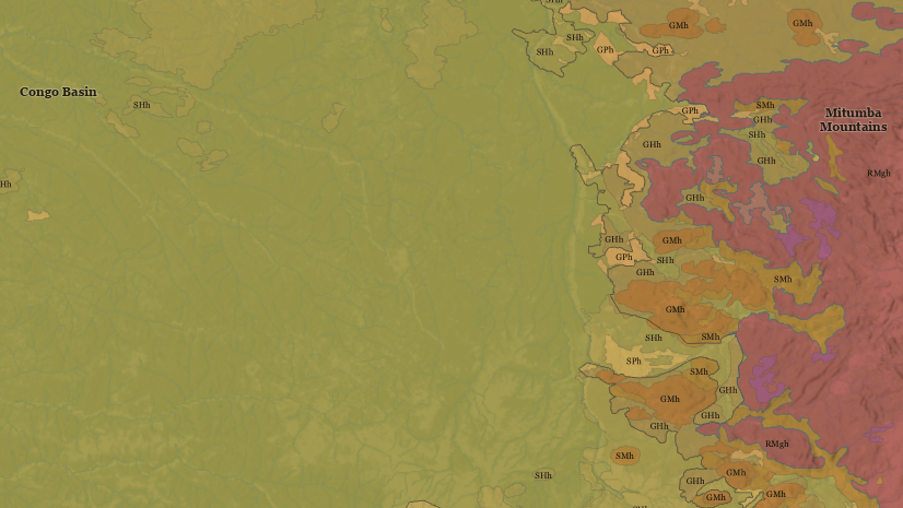
cfrye

Recent Posts

The next generation of mapping and cartography resources

By Charlie Frye, Esri Chief Cartographer

Mapping Resource Center - ThumbnailWe are transitioning from MappingCenter, where for over four years we have been sharing resources to help people create great maps with ArcGIS, to the new Mapping Resource Center. We are making this transition for several big reasons.

First, the release of ArcGIS 10.1 is a big deal with respect to sharing maps online. In particular, the web maps we can all make in ArcGIS Online are the future. They are how the value and the useful information held within GISs everywhere will reach many audiences. Our initial efforts on the new Mapping Resource Center will focus on web maps. We feel it is imperative to support ArcGIS users who are working to leverage the Web to deliver the value of their GIS to their customers.

Continue reading

Posted in Mapping | 5 Comments

Historic Conservation and Preservation web map templates

By Charlie Frye, Esri Chief Cartographer

Historic - Thumbnail

Two new map templates are now available in ArcGIS Online. Both support creating services and web maps that feature historic preservation and conservation content.  You can find these templates in Historic Conservation and Preservation ArcGIS Resources Group in ArcGIS Online.

The Historic Buildings & Districts Conservation and Preservation Web Map template is an ArcMap editing map, a set of editing workflows for creating and managing historical information about buildings, and a set of ArcMap documents for serving historical building information in a Web Map. Continue reading

Posted in Mapping | 2 Comments

Making a "map sandwich" on ArcGIS.com

By Charlie Frye, Esri Chief Cartographer

Last year we wrote about the concept of a map sandwich. A map sandwich is a basic formula for a legible map mash-up. This blog post explains how you make your own map sandwich on the ArcGIS.com Web site in 10 easy steps. Continue reading

Posted in ArcGIS Online, Mapping | Tagged , , , | 3 Comments

Introducing the 2010 User Conference web map and routing app

By Charlie Frye, Esri Chief Cartographer

UC 2010 Map Thumb

We are pleased to introduce the 2010 UC Web Map and Routing Application. This map is designed to ease the potentially exhausting experience of navigating the huge San Diego Convention Center. Continue reading

Posted in Mapping | Tagged , , , , , , | Leave a comment

Using multiple computers to cache ArcGIS Server map services

By Charlie Frye, Esri Chief Cartographer

Caching Thumb

We got a question the other day on Ask a Cartographer about how to cache map services with several computers. First, we want to explain why you would even want to do this. If you will be caching a map that covers a large extent and needs to be cached at large scales, it is possible that the caching job could take days or even weeks to process on one computer. For instance the World Topographic Map on ArcGIS Online. It would take about 8-10 weeks to cache completely on one computer. By spreading these large caching jobs across many computers, it will take less time to complete. Continue reading

Posted in Mapping | Tagged , , , | 2 Comments

Symbolizing the hillshade for the World Topographic map

By Charlie Frye, Esri Chief Cartographer

Symbolizing the Hillshade thumb

One of the things I promised myself that I would do last summer was write about some of the key design solutions used in the World Topographic Base Map. Our symbolization of the hillshade is one of the design characteristics that most distinguishes this map. The design intent was two-fold: 1) show shading similar to how hachures were used on hand-drawn maps [to see what I mean one of my favorite 18th century maps depicting the Battle of Bunker or properly Breeds Hill is a good example], and 2) display the low slope areas in white because this creates a ”non-competitive” background for data that is mashed up on this base map. Continue reading

Posted in Imagery, Mapping | Tagged | 3 Comments

Announcing the ArcGIS Data blog

By Charlie Frye, Esri Chief Cartographer

Data Blog - Thumbnail

September and October sure went fast. We on the Mapping Center team have been very busy working on mapping projects, and have not spent as much time here–but we’re finding a balance and will be getting more good blogs done soon (several are in the pipeline). Continue reading

Posted in Mapping | Tagged | Leave a comment

The "map sandwich"

By Charlie Frye, Esri Chief Cartographer

Map Sandwich - Thumbnail

Last week we started telling you about the new ArcGIS Online World Topographic Map. As I was working on the design of that map, with the intent of providing a better basis for mash-ups, I had an idea. It was born of frustration with the fact some mash-ups don’t work because too much information obscures the base map, making for an unreadable, often ugly result. Demographic layers represent a great example of the kind of information that just doesn’t always work well in a simple mash-up.

What I really needed was a way to “sandwich” the demography layer between the terrain and the reference information–that way the reference information would be legible, and I would still be able to understand the demography. Continue reading

Posted in Mapping | Tagged , , | 2 Comments

World Topographic map

By Charlie Frye, Esri Chief Cartographer

The Mapping Center Team is pleased to share the ArcGIS Online News announcement that includes the availability of the new World Topographic Map. As several members of the Mapping Center team played a significant role in the design and production of this map, we would like to begin telling you about this map. The World Topographic Map covers the globe to about 1:1,000,000 scale. Within the U.S. (excluding Alaska), the map scale extends to about 1:18,000. The map is a cached map and uses the Virtual Earth/Google Maps tiling scheme (WKID = 102113). What follows are some of the essentials everyone should know about this map, including that the service is free. Continue reading

Posted in Mapping | Tagged , | 4 Comments

Tips for caching ArcGIS Server map services faster

By Charlie Frye, Esri Chief Cartographer

How fast can you cache?  We keep asking ourselves that and keep finding that the more we know the faster we cache.

If you’re involved in the job of caching maps for online map services, you are already familiar with the need to optimize the process as much as possible so that it takes less time and effort. One way you can do this is to optimize how your maps are displayed – another is to optimize the environment you are caching your map in or the circumstances under which you are caching. Continue reading

Posted in Mapping | Tagged | 7 Comments