With the November update to ArcGIS Online we have added new functionally and included numerous enhancements. Here are the main highlights that impact configurable apps.
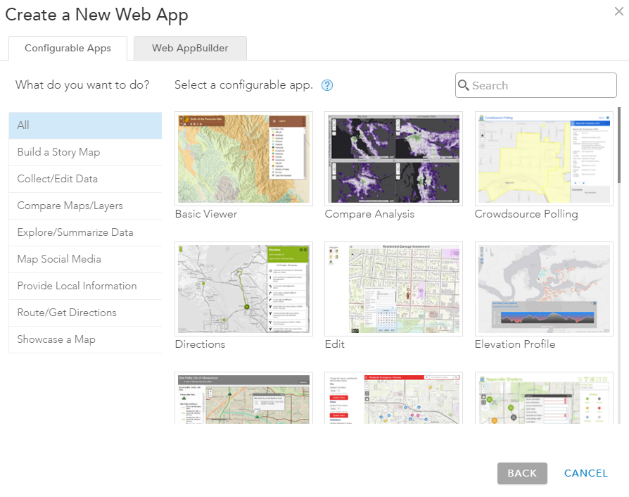
Configurable App Selection
There is a new user interface and experience for selecting which configurable app you want to use. Preset filters are in place so that you see only the apps available for what you want to specifically do with your app. If you want to see all configurable apps as you could before, the “All” filter is shown by default. Clicking on a different filter will display only the apps specific to that category in the tiled gallery. This new configurable app selection experience will be in place when choosing from the Map Viewer and My Content. Note that if you have a custom app gallery set within your Organization, this will not take advantage of the new filtering functionality. All apps in your custom gallery will display in the tiled gallery as before.
Custom Print Layout Support
If your Organization uses a custom print service which has its own layouts, both the Basic Viewer and Map Tools configurable apps can recognize these within their respective Print widgets. From the app’s configuration panel, you can enable or disable the option for “Display all Layout Options” based on your preference.
Embedded Maps Documentation
Newly added documentation has been included for using URL parameters with embedded maps. This includes a list of all available parameters with descriptions and examples.
New URL Parameter: locale
When configuring your apps with URL parameters, use the new “locale” parameter to have the app display in a different localization than what the browser is set to. This will be useful for offering multiple links to your app in different languages. To do this, just append the &locale=value parameter to the end of the URL of the app. An example for displaying the app in Spanish would be &locale=es
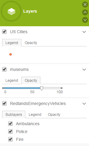
Layer List Widget Enhancement
Within the Basic Viewer and Map Tools apps, the Layer List widget has been enhanced to show sub layers, a legend, and an opacity slider. By default, these options will be enabled and your existing apps will look a bit different in the Layer List widget than before. To revert back to how they originally looked, toggle off the options you do not want in the configuration panel within configure mode of the app.
Retired Apps
As of the November 2015 update, the Legend and Twitter apps have been retired from the configurable apps gallery. For similar experiences with current apps, use the Simple Map Viewer in place of the Legend app and use the Public Information app in place of the Twitter app.
Basic Viewer Updates
The Basic Viewer now supports using a splash screen. There is a check box that can be toggled on or off within the configuration panel. Additionally, you can provide a title for the splash screen as well as further information as content text. Also, we have included functionality to allow feature popups to show in a floating panel instead of in the map. This increases visibility of features in the map since the floating panel will remain in the same position, and this, too, is an optional feature and can be controlled in the configuration panel based on preference. Lastly, as mentioned in above topics, the Basic Viewer now supports custom print templates and has new enhancements to the Layer List widget including sublayers and layer opacity control.
Crowdsource Polling Updates
Crowdsource Polling has been enhanced and will now be included in the configurable apps gallery. This app is designed to collect feedback from users where they can review information about issues or proposals and then cast a vote through the app. The creator of the app choses which layer in the map will be used for feedback as well as which fields will be used to store the vote counts and voter name information. Users will be able to sign in via Facebook, Twitter, Google+, or alternatively, cast their vote anonymously. These sign in options are controlled by the app creator in the configuration panel.
Directions App Updates
The Directions app now offers walking as an alternative travel mode. The user can toggle between driving and walking within the directions pane. Also, the ability to use Closest Facility has been added and can be set up in the configure panel. This includes an option to use your own closest facility service URL as well.
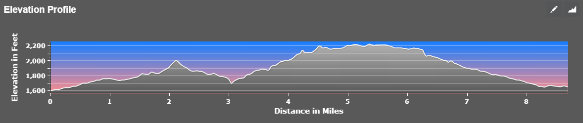
Elevation Profile Updates
The Elevation Profile has been replaced with a new version that gives a smoother, more simplistic design for visualizing routes and elevation profile data. The chart has been redesigned and the look and feel is fully customizable. The new design of this version allows it to embed more efficiently in web sites and story maps, and displays better in mobile device browsers. The name for this app does not change.
Introducing the Minimalist App
The gallery of configurable apps will now include a new app called Minimalist. This configurable app is designed to let the web map stand out as much as possible from the other elements of the app. Available functionality ranges from adding a legend and details panel to setting a custom logo and search tool. The Minimalist app also includes functionality to allow feature popups to show in a side panel instead of in the map, increasing visibility of features and other map phenomena. All functionality can be enabled and controlled in the configuration panel while in configure mode. This app sets mouse scrolling for zoom as disabled by default. Uncheck the option for “Disable scrolling in app” to change this. This is the same source code that we use for the embedded map, but by including it in the configurable apps gallery as an app, it will now be easier to take advantage of its capabilities without using URL parameters.
Story Map Basic Updates
The Story Map Basic app introduces several enhancements. The app now supports search using locator search and/or searchable feature layers. Subscriber content contained in the web map can now be shared publicly with the app. Furthermore, there is more control over the look and feel of the app including the ability to add a logo to the header with a URL and more color options for various components of the user interface. The updated Story Map Basic app is actually a new application. The older Story Map Basic has been retired but apps already created with it will continue to work. Any new app you create with Story Map Basic will use the updated app. If you want your existing Story Map Basic app to use the new features, simply republish your web map using the updated app.
Story Map Tour updates
There’s a useful new shortcut for Story Map Tour end users: They can advance through a Story Map Tour by clicking or tapping the main image.
Story Map Journal and Story Map Series updates
You can now create and edit web maps from within the Story Map Journal and Story Map Series builders. This makes it easier to update your web map without needing to navigate back to the Map Viewer and away from builder mode of the app.
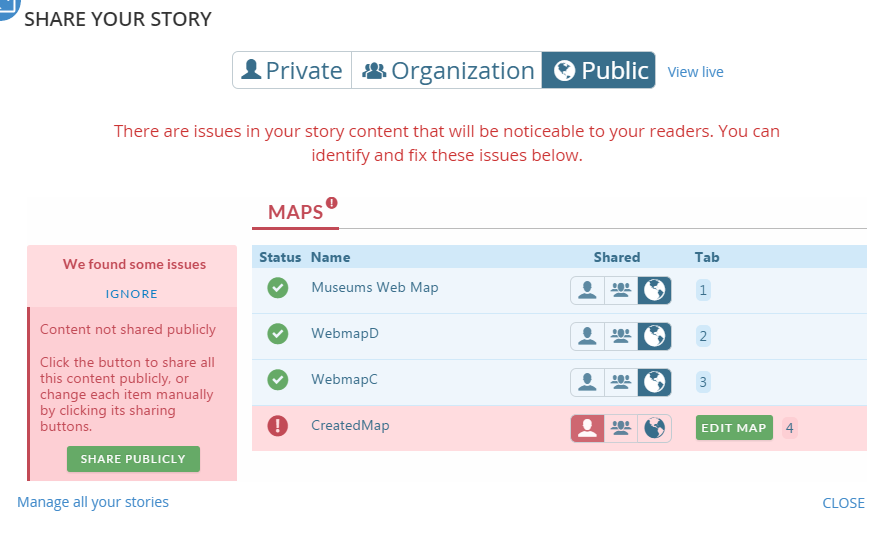
Furthermore, the builders now automatically check your story for any issues as you build it and enable you to easily troubleshoot and fix issues that come up. For example, if any content in your story is not accessible to the audience you are sharing it with, the builders will notify you and enable you to share that content appropriately or replace it. Note that the tools to check story maps for issues are also available in the My Stories section of the Story Maps website for use with Story Map Journal, Story Map Series, Story Map Tour and Story Map Swipe/Spyglass.
For more detailed information specific to what is new in Story Maps, please refer to What’s New in Story Maps (November 2015).


Article Discussion: