 Collector for ArcGIS extends the reach of ArcGIS into the field so that you can improve the accuracy and currency of your data. Using your mobile device you can collect and update spatial and tabular data managed inside of your GIS. Collector is available today in the iTunes App Store, Google Play and Amazon App Store.
Location Services
With your permission, Collector for ArcGIS can use location services to capture and update data. Location services use information from cellular, Wi-Fi, Global Navigation Satellite Systems (GNSS) networks and Bluetooth to determine your approximate location. A cellular or Wi-Fi network connection provides initial location information and helps you locate visible GPS satellites faster. Most cellular- enabled iOS and Android devices come with integrated GNSS receivers that include support for GPS/GLONASS/Galileo or Beidou systems.
Depending upon the device manufacturer, the locational accuracy of the integrated GNSS receiver can vary considerably. Most consumer-grade devices or GPS receivers are accurate up to about 5 meters. Bluetooth is another method of providing spatial information to location services. There are a number of external GNSS receivers you can pair with your device to determine location. Some are spatially accurate within 1 meter. These receivers can apply a differential correction to improve the accuracy of their positions using either a Satellite-based Augmentation System (SBAS) or a Real-time Kinematic system (RTK).
Location and Coordinate Systems
Understanding how Collector for ArcGIS and location services work with coordinate systems is important when you want the best accuracy from either an integrated or Bluetooth-paired GNSS receiver.
 By default, positions received from location services use the latest revision of the World Geodetic System (WGS 84) and Collector expects that the spatial information will be provided in this system.
When using differential correction, knowing the geodetic reference frame and epoch of the correction source is critical to creating accurate data. Both SBAS and RTK provide a set of corrections that your GNSS receiver applies using a geodetic reference frame to improve accuracy. The SBAS approach uses a celestial reference frame called the International Terrestrial Reference Frame or ITRF (to which WGS 84 is aligned to ITRF) and RTK systems may reference ITRF, or more commonly, may utilize a national or regional tectonic plate-based reference frame like NAD 83.
NOTE: If you plan to use RTK for differential correction, Collector does not provide the ability for you to choose a datum transformation (e.g., between NAD 83 and WGS 84). This is planned for a future update of Collector though.
Coordinate Systems and the Map
Coordinate systems and datum’s are important to understand when creating web map, layers and data sources.
The following describes the field data collection workflow from the perspective of coordinate systems and datum transformations.
![]()
DT1- Device to Web Map
When you use location services to create GIS features, they are projected into the coordinate system of the web map. The web map has a coordinate system that is defined by the basemap that you use. ArcGIS Online basemaps use the Web Mercator coordinate system and reference WGS 84. However you can use your own basemaps with particular coordinate systems in Collector.
NOTE: If you plan to use an RTK differential correction, ensure the location source, web map and web layers are using WGS 84. Collector for ArcGIS does not support setting a datum transformation for the location source and you may introduce error due to coordinate conversions when using a tectonic plate-based reference frame.
DT2- Web Map to Web Layer
When Collector synchronizes edits to web layers that you have published using feature services, the coordinate system of the web map will be compared to the web layer that has edits. If required, GIS features within the web layer will be projected to the coordinate system defined within the feature service. Though good practice to do so, it is not required that web layers within the web map have the same coordinate system.
DT3- Web Layers to Geodatabase Feature Layers
Web layers are contained within feature services that are often published from ArcMap. When publishing, the coordinate system of the active data frame is used as the coordinate system for your web layers. The coordinate system of the data frame can be different than the coordinate system of your Geodatabase feature layer.
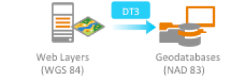
In the example above, you can store your GIS data in a local, tectonic plate-based coordinate system (e.g. NAD 83) and then project the active data frame to WGS 84. In doing so, you have control over the Geographic Coordinate System transformation used (using the default option to sort by layer’s extent is recommended).
Summary
If you plan to use Collector for ArcGIS with an external GNSS receiver, it is important to understand the ways in which coordinate systems and datum transformations can affect the GIS data that you capture. There are several touch points within the ArcGIS platform where coordinate conversions can introduce error.
For more information about Collector for ArcGIS and Coordinate systems, please read the following:


Commenting is not enabled for this article.