By Kyle Bauer, Learn ArcGIS Team, and Craig McCabe, Subject Matter Expert
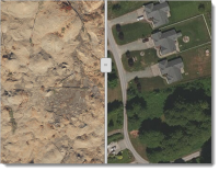 In March 2014, a massive landslide wiped out a rural community near Oso, Washington. The landslide dramatically altered the landscape, destroying homes and highways. A total of 43 people died in the tragedy. In order to fully understand the damage the mudslide caused, you’ll compare before and after images of the area.
In the new Oso Mudslide – Before and After lesson on the Learn ArcGIS website, you’ll configure a web app with the ArcGIS Online Web AppBuilder to spread awareness of the disaster. The app will feature before and after imagery of the Oso Mudslide in rural Washington State.
- Platform: ArcGIS Online
- Time: 1 hour
- Level: Beginner
Build skills in these areas:
- Creating an app with Web AppBuilder
- Adding metadata
- Comparing areas before and after a disaster
- Measuring the extent of impact
About the author


Article Discussion: