By Kyle Bauer, Learn ArcGIS Team
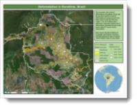 One of the most deforested regions in the Amazon rainforest is Rondonia, Brazil. The construction of roads has increased deforestation since the 1960s. In 2011, a Brazilian judge prohibited the construction of a road that would have traveled through a large stretch of protected land in Rondonia, with the goal of preventing more deforestation in the rainforest.
In the new Get Started with ArcMap lesson on the Learn ArcGIS website, you’ll learn to use ArcMap to estimate how much deforestation was prevented by prohibiting the proposed road. You’ll compare roads and deforestation within the study area to determine the pattern of existing deforestation. Then, you’ll digitize a road in the protected area to see what the pattern would have been there. At the end, you’ll communicate the results by designing a map.
Platform: ArcMap
Time: 3 hours
Level: Beginner
Build skills in these areas:
- Adding data to a map
- Analyzing relationships between data
- Digitizing features
- Symbolizing and organizing data
About the author


Article Discussion: