By David McCloskey, Cascadia-Institute.org
(posted by Aileen Buckley, Esri Cartographer)
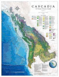
Chosen to grace the cover of the 2015 Esri Map Book, this map, by the Cascadia Institute, with cartography by Benchmark Maps, shows for the first time the natural integrity of Cascadia as a whole bioregion.
Cascadia is named for the whitewaters that pour down the slopes of her mountains. Home of salmon and rivers, mountains and forests, Cascadia rises as a Great Green Land from the Northeast Pacific Rim.
Cascadia curves from coast to crest—from the Pacific Ocean to the Rocky Mountains and Continental Divide. On the seafloor, Cascadia ranges from the Mendocino Fracture Zone to the Aleutian Trench in the corner of the Gulf of Alaska.
This layered, information-rich, award-winning map shows the distinctive character and context of the wider bioregion in several ways for the first time:
- Integrity in Depth: Shows the natural integrity of the whole bioregional fabric across borders (instead of cut-up political space); with accurate scale, features, and mutual proportionality, enabling new insight into in-depth relationships between locations and layers, revealing configurations helping create the distinctive character of Cascadia.
- Orientation: Aligns the body of the land and coastline correctly along the 125th meridian (rather than tipping it over awkwardly to fit on the page).
- Layers in the FIELD: Building the map through several layers—Terrain, Geology, Seafloor & Coastline, Icefields, Hydrology—Rivers & Lakes, Vegetation, Urban areas, etc.—shows the dynamic FIELD in depth, where composition of map layers follows the way the world works (in contrast to standard geography’s reductionistic “spatiology” of flat container space); here the Bioregional path offers a new approach for in-depth ecological mapping of dynamic weaves creating bioregions as “a place of places.”
- Boundaries: Delineates the natural boundaries of Cascadia clearly with accurate locations and identifying labels; especially in terms of the Cascadia Divides and the Continental Divide.
- Context: Locates the bioregion as riding the verge of Mountains & the Sea, in relation to the Northeast Pacific Ocean Rim and Cordillera of the North American continent in terms of terrain, rivers, etc.; especially situating Cascadia as one of the 21 major bioregions of Western North America (see Locator Globe).
- Land & Sea: Shows the many intimate intertwinings of Land & Sea characteristic of Cascadia, especially its fabulous intricately carved glacial coastline, and sheltered seas amongst islands.
- Seafloor: Shows the entire Cascadian seafloor with all its major features clearly delineated, with updated naming from current understanding of marine geophysical processes.
- Bathymetric Colors: Calls out the distinctive contour depths in an artistic way so they can be seen.
- Terrain: Uses 3-way directional illumination to add dimensional depth to physiographic shaded relief; especially calling out the alternating rhythm of windward and leeward rainshadowed sides.
- Hydrology: In tectonically controlled watersheds of the Northern Cordillera, the map shows perennial rivers & lakes as entire drainage networks across borders, including the major continental rivers Cascadia feeds beyond her boundaries.
- River Labels: Ranked hierarchically by size in long-term annual average flow volumes (m3s, cfs) so you can grasp at a glance their relative size and significance.
- Icefields: Shows the 79 major Icefields of Cascadia—the greatest non-polar Icefields in the world—by geographic section, with proposed names for over half for the first time so they can be better tracked; and shows connections of Icefields to Rivers, as well as to glaciated submarine valleys, canyons, and channels. The Icefields layer provides a key historical baseline in a rapidly melting environment.
- Vegetation: The major contribution of the new Cascadia map! Providing a seamless integrative cross-border coverage of Forest Types and other Land Cover in detailed 30 meter resolution; offers a new comprehensive region-wide Forest Framework of 27 major Forest & Woodland assemblages presented in the Legend, with each type’s abbreviation appearing in a color box—e.g. ICH—which is also pinned to its specific locations on the map for ready reference.
- Legend: Along with other Land Cover, the contextual legend shows each forest type—e.g. ICH or “Interior Maritime Cedar-Hemlock”—in terms of: (a) its species composition, (b) in order of prevalence, (c) by geographic section—North, Center, South (which can be checked on separate species distribution maps), for (d) both conifer and broadleaf trees. This innovative Legend sets a new standard.
- Key: The contextual Legend is linked to a diagnostic Key listing 72 Native Trees of Cascadia organized by Families, translating common-language abbreviations used in the Legend—e.g. WRC for Western Red Cedar—into the scientific Thuja plicata; with the distributions on the map, Legend and Key together offer a new level of comprehensive detail for understanding the composition of Cascadia’s forest assemblages on the ground, for comparison of species occurring across different
types, as well as shifting floristic geographies, providing another baseline for understanding change. - Color Palette: Reserving color here for Vegetation (rather than conventional elevation tints), this map provides a coherent and grounded color palette for Cascadia in terms of (a) intrinsic color (e.g. cinnamon-orange for Ponderosa Pine), (b) distribution along regional gradients of moisture and temperature, (c) figure/field contrasts with adjacent colors, and (d) resonance of the overall color field.
(Dialing in “just so” over sixty mutually-influencing colors so they work together part-and-whole was a Herculean task, and offers a new Bioregionally grounded strategy for color palette design). - Labels: A Region is a House of Names! Over a year was invested in choosing feature names that most significantly express bioregional character and context; organized in 15 different layers, these labels were carefully composed to best articulate a particular feature (e.g. the massif of Mt Logan) and not compete with one another; overall, label names were laid out to settle into the landscape naturally, so landscape remains primary and labels secondary.
- Colors of Landscape vs. Labels: Great care was taken in design to keep Vegetation colors and Bathymetric-Seafloor colors vibrant and saturated so the landscape stayed as foreground with labels as background; (reverse of conventional toning down of landscape and vegetation into muted monotones to increase label contrast and readability, so human labels domesticate nature).
- Readability: this map was designed to be readable from different distances—from across the room, from four feet away, as well as nose close-up for detailed inspection.
- Memory & Depth: Landscape is the holder of memories… As maps tell a story, depth is found in time as well as the layers depicted—so care was taken to include several lost or submerged features such as The Great Cascades of the Columbia, Celilo Falls, and Kettle Falls. Similarly, the caldera of the great Yellowstone HotSpot Volcano is outlined in fiery orange-red magma, etc.
- Evocative: The Cascadia map is intended to be evocative as well as informative. A good map opens a window onto a world—a special one opens up that world as well! We want a map with depth, significance, and resonance—so that if you immerse yourself in its life, it opens and flows out around you. We hope this map opens up the world of Cascadia in a new way…
David McCloskey © May 2015
Cascadia-Institute.org


Article Discussion: