The ArcGIS Predictive Analysis Tools Add-In is available for download. The ArcGIS Predictive Analysis Tools Add-In is a set of tools used by analysts to build models to predict the location of moving or stationary targets or events. You can build models based on shared tradecraft or doctrine, or you can derive the models from a set of observations. The Add-In includes several tools that you use together to make predictions.
The Query Builder (also available in the Query Analysis Add-In) lets you build, save, and load queries to find locations where a set of conditions is true for a group of single-band rasters. You can build queries to predict future events and activities, such as the likely landing spots for a smuggler’s boat. If you already know what values for the various environmental factors are most important in determining the location of your event of interest (for example, that smugglers prefer beaches within X distance of a road, but more than Y distance from a populated place), you can use the Query Builder to manually construct the query, then apply it to your rasters to see what locations satisfy those conditions.
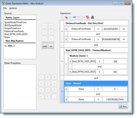
Query Editor
The predictions may also be derived from a set of observations. The Query Factor Impact Table tool allows you to take a set of observations, such as locations where smugglers’ boats have been captured unloading, and compare these observations to a group of rasters to determine what values are characteristic of these points. You can then generate a query for the Query Builder tool, and apply it to see what other areas are like the observed locations.
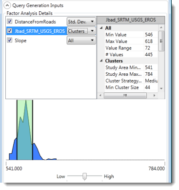
QueryFactor Impact Table tool
The SPOT tool lets you interactively examine the results of a query, to determine why a given location does or does not satisfy the query. This can be useful for interactively refining a query expression.
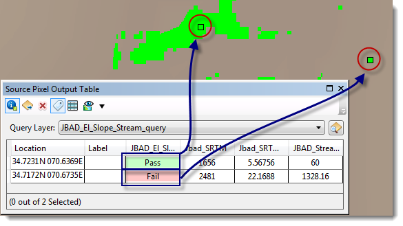
SPOT tool
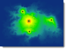
The ArcGIS Predictive Analysis Tools Add-In also includes a Speed Model Builder that lets you take multiple environmental factors into account in modeling how fast a vehicle or person could move over the terrain. The Speed Model Builder works very much like the Query Builder, but you use the results to find how long it would take to travel from a given location to a destination.
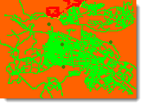
Speed Model results
The Time From and Distance From tools let you build rasters that help you determine the shortest route (measured in travel time or minimum distance) to one or more locations across a landscape. These rasters can be built with barriers, so for example, the shortest route to a harbor for a boat would have to avoid shoals and islands, or the shortest route to a base might have to avoid roadblocks or minefields.
Speed Model time from points
The Route Finder tool works with the output of the Time From and Distance From tools to let you interactively click on the map and find shortest routes. The resulting tracks can be exported as time-enabled features, and played back in the Time Analysis Window.
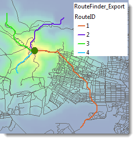
Route Finder results
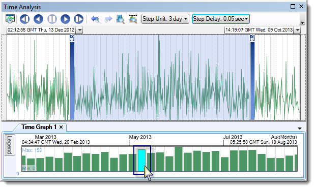
The Time Analysis window lets you interactively look at the movements or occurrence of time enabled features. It lets you create multiple graphs of events, and play back features and graphs. You can use it to identify when multiple vehicles travelling toward a location are likely to meet, or to see at what time the smuggler’s boat is likely to enter the predicted cove.

Commenting is not enabled for this article.