Last update: February 25, 2024
A story map (whether in “classic” or “modern” ArcGIS StoryMap mode) is an Esri medium for sharing not only data, photos, videos, sounds, and maps, but for telling a specific and compelling story by way of that content. This is all done with sophisticated cartographic functionality that does not require advanced training in cartography or GIS. Therefore the beauty of Esri story maps is that, depending on the chosen complexity, they can be built in anywhere from a few minutes to a few days, using the free public accounts and data available within ArcGIS Online. Story maps are essentially applications built from web maps which in turn are built from web-accessible data (including OGC WMS, WFS). With the beauty and utility of underlays such as the Esri Ocean Basemap, as well as a small tsunami of ocean content percolating up through free public accounts on ArcGIS Online, and on premium subscription accounts, it’s no wonder that we are seeing an “ocean” of interesting story maps.
Hot! This story map is about ArcGIS Hub, a new technology currently in worldwide adoption, for creating and publishing open data in an easy and accessible way. See this great Hub example from NOAA NCCOS on Living Shipwrecks in 3D, or the Alaska’s Coastal Mapping Strategy, or the Deep Ocean Observing Strategy, or the Caribbean Coastal Critical Infrastructure Hub, as well as this gallery of Ocean Hubs, many of which include story maps. Hot!
HOT! The new ArcGIS StoryMap COLLECTIONS are a wonderful way to experience a series of storymaps, allowing you to go sequentially from one story to the next if you would like. See these favorites:
- Favorite Esri-Produced Stories of 2022, including stories about Challenger Deep and why mapping the seafloor is important
- The Deep, a series of stories about the dives of Victor Vescovo, Caladan Oceanic, and colleagues to the deepest spots in the world’s oceans
- Explore the Ocean with Changemakers
- SONAR, LiDAR, and Other Tools for Mapping the Ocean
- Restoring our Ocean
- 2021 ArcGIS StoryMaps Challenge
- Fisheries and Oceans Canada, Marine Spatial Data Infrastructure (MSDI) GIS Application Collection
BELOW is a catalog of my FAVORITE ocean/coastal story maps, both “classic” and “modern,” for your enjoyment (use the “Find” feature of your browser, normally control-F, to search the entries):
Made by Esri, Inc.
See also the GROUP in ArcGIS Online and the COLLECTION compiled for the 2017 Ocean GIS Forum.
- 21st of June World Hydrography Day and IHO’s 100 years…
- Across America, Communities Restoring Estuaries (Restore America’s Estuaries)
- All About The Ocean
- Arctic Ocean Basemap – Sea Ice Extent
- Bahamas Before & After Swipe Map – part of the Hurricane Dorian Portal
- The BBC’s Blue Planet II – Episode 1: One Ocean
- The BBC’s Blue Planet II – Episode 2: The Deep
- Blue Ribbon Panel of Experts for the Global Partnership for Oceans (GPO)
- Carto Hack: Mapping Water Depth With Opacity
- Challenge Accepted (Challenger Deep 2022)
- Charles Darwin’s Voyage of the Beagle
- Citizen Science ArcGIS Gallery (including several ocean-themed story maps)
- Climate Migrants
- Country Income Level and Exclusive Economic Zones (in support of the Global Partnership for Oceans)
- Discovery of the Deep (Vescovo et al., “The Deep,” Ch. 4)
- Earth’s Biggest Storms: Tropical Cyclones
- Ecological Marine Units: A Three-Dimensional Mapping of the Ocean Based on Environmental Data (inception of the project)
- Esri Chief Scientist 2015 Map Tour (including furthering the Ocean GIS Initiative)
- Eye of the Hurricanes (How-To: Hurricane Map)
- Fiery Cross Reef Swipe
- Find Your Beach
- Flooding Expecting to Worsen: Nuisance flooding impacts increase with sea level rise
- Furthering the Ocean GIS Initiative (Chief Scientist, 2013)
- GEO (Group on Earth Observations) in Action (including sustainable fishing, ocean color, MBON, Blue Planet, GEOSS, and more)
- GIS for the Oceans Case Studies (and related article)
- GIS Success Stories Around the World (including some for coast and ocean)
- Global Submarine Cables (web app)
- How Deep is Challenger Deep?
- How Ocean Currents Impact the World
- Humanity of the Deep (Vescovo et al., “The Deep,” Ch. 2)
- Hurricane Harvey Before/After Imagery: Houston
- Hurricane Harvey Before/After Imagery: Port Aransas
- Hurricane Harvey Resource Catalog
- Hurricane Irma Post-Event Imagery
- Hurricane Irma Resource Catalog
- Hurricane Maria Resource Catalog: Ready-to-Use Apps
- Hurricane Nate Resource Catalog
- Hurricanes and Tropical Cyclones Overview
- Hurricanes: Top 10 Most Damaging in the US (as of 2012)
- Illuminating the Deep (Vescovo, Sullivan, et al., Challenger Deep, “The Deep,” Ch. 1)
- Indian Ocean Research Data: Past, Present, Future
- Innovation of the Deep (Vescovo et al., “The Deep,” Ch. 3)
- Inspire and Take Action (2021 ArcGIS StoryMaps Challenge for Restoring Our Ocean)
- Invasive Mussel Species, USA 1998-2013
- Kayaking the Sea of Tranquility
- Location Intelligence for Ports
- The Longitude Prize of 1714
- Maritime Community Building (with the International Hydrographic Organization, IHO)
- Motion of Tectonic Plates
- National GIS for Statistics (including Maritime, NOAA’s Electronic Nautical Charts)
- New Island in the Ring of Fire
- Ocean Acidification: Aragonite Saturation (swipe map) (climate change)
- Ocean Acidification: The Silent Storm (climate change)
- Ocean Color: Chlorophyll-a in Our Oceans
- An Ocean of Data
- Ocean Plastics (with EPA and Ocean P3 Systems)
- Ocean Sustainability Pilot Project (in support of the Global Partnership for Oceans or GPO)
- Offshore Palm Beach County (Florida, 3D)
- Our Oceans LIVE! (webcams around the world)
- One Night Before the Mast (Ocean Institute at Dana Point)
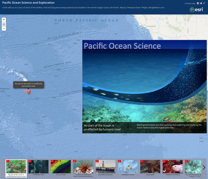
- Pacific Ocean Science and Exploration
- [Modern] Piracy & Time Travel
- The Power of Location in Marine SDI (for the Marine Spatial Data Infrastructures Working Group Meeting of the IHO, Tokyo, Jan 2016)
- The Real Pirates of the Caribbean Updated!
- The Rise and Fall of Hunga Tonga-Hunga Ha’apai
- Seafloor Investigator (with spyglass)
- Marine Aquaculture
- Sea Level Rise: Resources for Understanding Impacts and Engaging with the Community New!
- Sediment Conditions in the Southern California Bight (web map only)
- Seismic Illumination
- Shark GIS!
- Severe Weather Public Information Map (web map rather than story map)
- Speaking the “Language” of Spatial Analysis via Story Maps (blog post – Esri Insider 2014 Top Ten)
- The Spilhaus World Ocean Map in a Square
- Story Maps…for Data Synthesis, Communication, Dissemination (also a conference poster)
- StoryMaps Weekly Waypoint: 2021 ArcGIS StoryMaps Challenge for Restoring Our Ocean Edition
- Titanic: Fate of its Passengers
- Trinidad Coastal Erosion
- Voyage of the Vermilion Sea
- What Causes Ocean Currents?
- What is Under the Ocean’s Hood? (Ecological Marine Units fence diagrams)
- Why We Map the Ocean Floor
Made by Esri Distributors
- Prince Albert I of Monaco: Scientific Explorer (in French)
- Esri France Ocean-Themed Story Maps by Educators (in French)
- Honu: A Story Over Water and Plastic (in French)
- Plastic: From the Source to the Ocean (in French)
- Plastic Pollution of the Oceans: Awareness and solutions (in French)
- Project Rome Ocean World: Italian Explorer Sailing Around the World (in Italian)
- #PrayforAirAsia QZ-8501
- Sargasso Sea and TransAtlantic Expedition (in Danish)
- Shipwrecks and Remote Sensing (app needs updating)
- War in the Mediterranean Sea, 1940-1943 (in Italian)
Made by Esri Users
- 15 Years of Ocean Intelligence (Ocean Networks Canada)
- 2015 Fishing Year: Atlantic Sea Scallop Managed Waters (2015 Esri Ocean GIS Forum App Gallery)
- 2017 Estuaries Report Card: Water Quality
- 2020 NOAA Business Brief
- 2020 Spring Flood Outlook
- $34.3 Million for NOAA Restoration Efforts in 2018
- Adapt Virginia: Evidence-based Planning for Changing Climate, Virginia Institute of Marine Science Center for Coastal Resources Management (VIMS CCRM)
- Adaptation Stories: Building Modifications
- Adaptation Stories: Engineered Shoreline Structures
- Adaptation Stories: Financial Incentives
- Adaptation Stories: Managed Retreat
- Adaptation Stories: Planning
- Adaptation Stories: Transportation Infrastructure
- Adaptation Stories: Water Storage and Management
- Adaptation Stories: Zoning and Building Codes
- Living Shorelines: Using Natural and Nature-Based Features
- African American History Month in the National Marine Sanctuaries
- Alaska Bathymetry: Alaska Fisheries Science Center
- Alaska’s Changing Ocean – Exploring Ocean Acidification: Impacts and Response New!
- Alexandra Rao: A Research Portfolio
- Antarctica StoryMap Collection
- Antarctica, The Southerly Extreme (2016 Esri Content Challenge 1st Prize Winner)
- Applied Oceans Research Group MultiSpectral Acoustic Backscatter Research (COGS NSCC)
- Applied Oceans Research Group Multibeam Mapping and More Overview (COGS NSCC)
- Aquarium of the Pacific Gallery (penguins, whales, steelhead, seafood, watersheds! Also in the 2015 book Ocean Solutions, Earth Solutions)
- ArcGIS as a Tool to Guarantee Safe Navigation in Buenaventura Bay, Colombia (in Spanish)
- The Arctic: Closer Than You Think
- Arctic Analysis Overview
- Argo: A Window into the Ocean (plus 3D web scene of all operational elements under JCOMMOPS and Esri Dashboard Prototype)
- Atmospheric Rivers: Weather, Climate, & Societal Interactions
- Attack of the Blobs (2016 Esri Content Challenge 2nd Prize Winner)
- Atlantic Shipwreck Density by OCS Block
- Atlas of Stellar Sea Lion Haul-Out Sites in Oregon
- Audubon Society’s Pacific Flyway Marine Important Bird Areas (IBAs) (2014 Esri Storytelling w/Maps Contest Winner)
- Audubon Society’s Piping Plover
- Australia’s Great Barrier Reef
- Beauty from Above (citizen science in Belize)
- Benthic By-Catch in the Falkland Islands
- Benthic Habitat Mapping and Assessment in the Wilmington-East Wind Energy Area
- Beyond the Boundaries: Regulations Data for Informing Marine Conservation Targets (MPAs)
- Blacktip Bait (Moorea)
- Blue Urbanism: Tackling Macro Marine Pollution in the Halifax Harbour
- The Bonds of Water (2016 Visualize Your Water Challenge Finalist)
- A Brief Study on the Ecological Importance of Cephalopods
- Building on the Edge (all about Connecticut coastal management)
- Building a Greener Future in Galway Bay (Ireland)
- California’s Ocean Surface Currents
- California’s Wild Coast (TNC Point Conception Institute, Dangermond Preserve) New!
- Camarillo Springs, California Heavy Rain, Flash Flooding, and Debris Flow Event December 11-12, 2014
- Can You Name the Top 10 Most Beautiful Ports in the World? (GIS Day 2018 online game)
- Canada’s Oceans: Planning for a Better Future
- Caribbean Marine Maps (TNC StoryMaps Collection and featured at the 2021 Esri Ocean, Weather, and Climate GIS Forum
- “Catch the King:” A King Tide Mapping Event, November 2017
- Category H5 Hurricanes Since 2000 (USC student project)
- Charting the Future of Seafood
- The Chesapeake Bay: A National Treasure In Trouble (2016 Visualize Your Water Challenge Finalist)
- Chesapeake Bay Program’s Cleaner Air, Cleaner Bay (plus video)
- Chiloe Island (Chile)
- Choptank River Complex Habitat Focus Area (HFA)
- Clark Magnet School Kids and their ROVs (and see the great YouTube video)
- Clark Magnet School Kids Study Marine Debris in Long Beach, San Francisco and Marina Del Rey Harbor, and Boston Harbor and Philadelphia
- Clark Magnet School Marine Debris Surveys, 2014
- Clark Magnet School, All Story Maps
- Climate Change in Earth’s Polar Regions (2016 Esri Content Challenge 3rd Prize Winner)
- Coast Survey History: Geodetic Survey Baseline
- Coastal Cleanup Scrapbook (Living Oceans Society)
- Coastal Dynamics and Risks (in French)
- Coastal Ecosystem Learning Centers (CELCs) (US, Canada, Mexico; from the 2015 book Ocean Solutions, Earth Solutions)
- Coastal Flooding
- Coastal Monitoring, Barrow, Alaska (do not use with Safari browser; 2016 Esri Storytelling w/Maps Contest Entry)
- Coastal and Offshore Permafrost Rapid Response
- Coastal Resilience Project Tracker: Climate Ready Boston
- Connecticut’s Coast: Then and Now (2016 Esri Storytelling w/Maps Contest Winner)
- Conserve Wildlife Foundation of New Jersey Annual Report
- Considering Atlantic Shipwrecks when Planning Offshore Energy
- CO-OPS’ QuickLook and Hydrographic Survey Support During 2017 Hurricane Season
- COVID-19 and Ship Noise (as presented at the 2020 Esri Ocean, Weather, and Climate GIS Forum)
- CREAT Climate Scenarios Projection Map (EPA)
- Cyclone Gita Crowdsource Story Map
- Danajon Bank (Philippines)
- The Data Behind the Search for MH370 (missing Malaysia Air flight)
- Data Collection for NOAA’s VDatum Program by JOA Surveys
- Decadal Chlorophyll Changes in the West Antarctic Peninsula (New College of Florida Undergraduate Student Project)
- A Decade of Disappearance: Bull Kelp in the San Juan Islands (Samish Territory, 2021 Esri Ocean, Weather, and Climate GIS Forum Digital Map Gallery)
- Deep Ocean Observing Strategy (DOOS)
- Deep Sea Coral Protection in US Waters
- Deep Sea Corals and Sponges of Alaska
- Delaware Watersheds Highlights
- Demonstration of Stormwater Control Measures
- Devastating Effects of Climate Change on Coastal Florida (2016 Esri Content Challenge Honorable Mention)
- Discovering Deep-Sea Corals: Predictive Habitat Modeling in the United States
- Diving Into ROV Research at Cordell Bank National Marine Sanctuary
- Discovering Deep-Sea Corals
- Drones and Open Data (for citizen science)
- DUNEX Pilot Experiment (nearshore, coastal North Carolina)
- Earth’s Magnetic Field: The Force That’s Always With You
- The Eco Angels & M.E.R.maids: Using GIS Against Marine Debris (Clark Magnet High School 2017 Esri Ocean GIS Forum Plenary)
- El Nino Wet Season Rainfall in Hawaii
- Endangered Reefs, Threatened People (coral reefs and people in a high CO2 world)
- Ensuring South Georgia’s Future: A Visual Exploration by iLCP Fellows
- Es² Deepwater Horizon Response (oil spill) (2014 Esri Storytelling w/Maps Contest Winner)
- Essential Fish Habitat Proposal, Monterey Bay (from the 2015 book Ocean Solutions, Earth Solutions)
- Establishing Baselines on Fiji’s Coral Reefs
- Estimating the Circulation and Climate of the Ocean (ECCO) (storymaps and much more)
- The Evolving Quest for Arctic Power (Harvard Kennedy School Belfer Center Workshop student project)
- exactEarth Gallery (includes web maps for the Arctic, historical ship positions, historical ship tracks, shipping density maps)
- exactEarth Gallery on ArcGIS Online (includes web maps and downloads)
- exactEarth Horizon (web maps of global ship positions from satellite AIS data)
- exactEarth ShipMapsTM (variation on the story maps concept w/ environment protection, piracy monitoring, Arctic monitoring, port management, casualty alerting, and fishery monitoring themes)
- Expedición Atlantic Seamounts 2014 – El Hierro (in Spanish)
- Exploring California’s Seamounts
- Exploring and Caring for Jamaica Bay (StoryMap Collection)
- Exploring Deep-Sea Corals in the Gulf of Maine
- Exploring the Diverse Underwater Flora and Fauna in Kilkieran Bay (Ireland)
- Exploring the Fish and Climate Change Database (FiCli) (2021 Esri Ocean, Weather, and Climate GIS Forum Digital Map Gallery)
- Extreme Fish of the Chesapeake Bay, Virginia Institute of Marine Science
- Extreme Water Levels during the 2021 Hurricane Season
- Farming in Water (aquaculture)
- Favorite Coastal Parks of Wisconsin Sea Grant
- Finding Safe Anchor: Employing Vessel Traffic Data in Jacksonville, Florida
- Fisheries Conflicts: Social-Ecological Drivers and Impacts on Human Security
- Fishing for a Future: The Artisanal Fishers of Ancón
- Fishing Hotspots of the North Sea (related U. of Groningen press release)
- Five Reasons We Need Healthy, Working Oceans (Living Oceans Society)
- Flight MH370: Interactive Timeline (Missing Malaysia Air)
- Florida’s Beautiful Aquatic Preserves
- The Florida Coastal Mapping Program
- Forms and Coastal Geology (in French)
- For the Fish: The Stories of Alaska’s Fish Habitat Partnerships
- Fort Bribie – Defending Brisbane (Australia) in WWII
- From Micro to Global (microbial processes)
- From Shore to Sea: Vessel Traffic in the Salish Sea
- Gambier Islands of French Polynesia
- GEOG 420-520 Marine Geography: GIS for a Blue Planet (Presented by ODU at 2017 and 2018 Esri Ocean GIS Forum)
- Georgia Coastal and Marine Planner (GCAMP) Story Maps and Apps Collection
- Gliding through the Blue Frontier (NOAA Underwater Glider Project, Caribbean)
- Global Multi-Resolution Topography Synthesis (Bathymetry, GEBCO)
- A Global Outcry From Communities Seeking Ocean Justice
- Great Barrier Reef Catchment Loads Monitoring Program (2016-2017)
- Great Barrier Reef Catchment Loads Monitoring Program (2017-2018)
- The Great Bear Sea: Meet the Residents
- Great Lakes Coastal Land Use Scenarios
- Great Lakes Coastal Wetland Restoration Assessment
- Great Lakes Mercury Sources Revealed
- Great Lakes Region Land Cover Report
- Gulf of Mexico Ecosystem Services Viewer
- GRID Arendal Story Maps Gallery (Eutrophication, marine mammals, endangered reefs, World Ocean Assessment, Sustainable Development Goals, much more)
- Gulf Region Land Cover Report
- Gulf Spill Early Restoration Projects
- Habitat Focus Areas Showing Results
- Habitat Mapping and Classification in the Northeast USA (including CMECS)
- Haida Gwaii (British Columbia, Canada)
- Harbor Seals in New Jersey
- Harmful Algal Blooms in California
- Healing Our Oceans With Data (Ocean Health Index-OHI + Esri Partnership)
- Healthy Habitat, Healthy Oceans (Oceana focus on Oregon, California, Washington benthic habitats)
- Heavy Metals Sediment Analysis Between LA Harbor & LA River (2018 Esri Ocean Forum Plenary, Clark Magnet School)
- Highlights of Global Climate 2016 (World Meteorological Organization, WMO)
- Highlights from NOAA Education
- The History Behind Flooding in Charleston, South Carolina
- How to Manage a Sinking Island (Cook Islands)
- How are Ocean Conditions Changing?
- The Humboldt Current Ecosystem: How Earth Systems Influence Ocean Productivity and Biodiversity
- Hurricane Harvey Before/After Imagery: Houston
- Hurricane Harvey Photo Story Map
- Hurricane Hugo: 25th Anniversary
- Hurricane Incident Journal (FEMA)
- Hurricane Irma Photo Story Map
- Hurricane Katrina at 10 (NOAA National Centers for Environmental Information)
- Hurricane Katrina: 10 Years Later (NOAA Office of Coast Survey)
- Hurricane Katrina +10: A Decade of Change in New Orleans
- Hurricane Katrina, Lower Ninth Ward, New Orleans: Then and Now (Esri UK Swipe)
- Hurricane Matthew: 5 Top Concerns?
- Hurricane Matthew: City of Charleston Hurricane Info Maps
- Hurricane Matthew: Who’s at Risk?
- Hurricane Sandy One-Year Anniversary
- Hurricane Sandy Recovery: Building a More Resilient Atlantic Coast
- Hurricanes Punched Hard This Season, Which Became as Active as NOAA Predicted (2017)
- Hurricanes and Tropical Cyclones Overview
- Hutchinson Island Beach Renourishment Project, Martin County, Florida (from the 2015 book Ocean Solutions, Earth Solutions)
- Hydrography of Galway Bay, Ireland (spyglass of bathymetry)
- Hydroscheme 2021 (Australian Hydrographic Office)
- Hydrospatial: The Extension of Hydrography
- IC GIS Portal (Maritime activities of the National Geospatial-Intelligence Agency or NGA)
- Improving Coastal Community Resilience in the Great Lakes
- Improving Our Coastal Ocean (GEO Planet & Esri, SDG 14)
- In Their Own Words: Women Doing NOAA’s Work (Women’s History Month 2020)
- Increasing our Knowledge of Antarctica with Hydrography
- Industrial Ocean Pollution
- Influence of Discharge on Tow Paths (using Automatic Identification Systems or AIS)
- The International Coastal Atlas Network (ICAN): Linking Coastal Web Atlases Across the Globe
- ICAN 8: Coastal Web Atlases Enhancing Ocean Literacy (Intl Coastal Atlas Network Workshop Report)
- International Coordination to Map the World Ocean (Seabed 2030)
- International League of Conservation Photographers (see other iLCP entries on this page)
- Introducing the 2022 NSF REU/RET Cohort (Citizen Science GIS, Florida, Belize)
- An Introduction to FEMA Coastal Floodplain Mapping
- Investigating Coral Bleaching Using Real Data (NOAA Data in the Classroom)
- Investigating El Nino (NOAA Data in the Classroom)
- Investigating Sea Level Using Real Data (NOAA Data in the Classroom)
- Ireland Beneath the Waves
- IUCN World Conservation Congress Special Congress Excursions (Hawaii 2016)
- Jobs in the Fishing Industry
- Julie’s Improbable Flight (the journey of a young osprey)
- Kachemak Bay Ecosystem Assessment Project: Kasitsna Bay Laboratory (Alaska)
- Key Case Studies of Resilience in Action (US Climate Resilience Toolkit)
- Kilkieran Bay Marine Life
- Killer Whales (New College of Florida Undergraduate Student Project)
- The King Tides Project: Snap the Shore, See the Future
- The Legend of the Lost Buoy
- Let’s Go Dive! (Mauritius)
- The Life of a CDIP Wave Buoy
- Lionfish Invasions in the Caribbean, Gulf of Mexico and Atlantic (2014 Esri Ocean GIS Forum Story Map Contest Honoree)
- Living Shorelines: Using Natural and Nature-Based Features (Adapt Virginia)
- Long Beach Climate Change Preparedness and Resiliency (2015 Esri Ocean GIS Forum App Gallery)
- Long Island Sound Seafloor Terrain Swipe Map (bath vs. sidescan)
- Louisiana Departments of Education, of Health, and of Transportation and Development: Coastal Flood Risk and Resilience
- Louisiana’s Working Coast
- Lower Sheboygan River Habitat Restoration
- Mactaquac Aquatic Ecosystem Study (MAES) (Canada)
- Mapping America’s Coral Reefs (NOAA)
- Mapping Coral (TNC)
- Mapping Human Uses of the Ocean (with great ANIMATIONS, downloads of documents & maps, + links to MarineCadastre.gov) (2015 Esri Ocean GIS Forum App Gallery)
- Mapping, Classifying, and Protecting Seamounts (from the 2016 book Ocean Solutions, Earth Solutions, 2ND EDITION)
- Marianas Tasi Pride: The 2015 International Coastal Cleanup in the CNMI
- Marie Tharp’s Seafloor – A Story Map for Marie Tharp’s 100th birthday
- Marine Aquaculture
- Marine Conservation – Route of Parks of Chilean Patagonia (Fundación Rewilding Chile) New!
- Marine Conservation Targets: Protecting 5% of Marine and Coastal Areas | Map Journal version (Canada)
- Marine Debris Clean Up in Samish Traditional Territory
- Marine Debris Removal and Assessment in the Northwest Hawaiian Islands (2016)
- Marine Ecosystem Services and the Sustainable Development Goals (SDGs)
- Marine Litter (Debris) in the Mediterranean (in Italian)
- Marine Protected Areas 2020: Building Effective Conservation Networks
- Marine Reserves, Quintana Roo, Mexico
- The Maritime Alliance: Promoting BlueTech and Blue Jobs (an entire organizational web site supported by a story map)
- Mesophotic and Deep Benthic Communities Expeditions New!
- Michigan Shipwrecks
- Mission Blue Hope Spots (Collection)
- Mitigating Marshes Against Sea Level Rise: Thin Layer Placement Experiment (a student analytical poster)
- Monterey Bay Marine GIS Users Group Meeting 2017
- Moonpenny’s (Maritime) Coffee Company (released April 1st!)
- Moving Water South of Lake Okeechobee (Florida), 2014-2015
- My Lens: South Africa’s Marine Spatial Planning Journey
- Native Olympia Oyster Collaborative (catalog of project sites)
- Naval History and Heritage Command Story Maps (WWI, Pearl Harbor, USS Indianapolis, USS Houston)
- Nautical Safety Monitor, Accidents at Sea (North Sea, in Dutch)
- Networking Coastal Web Atlases to Promote Biodiversity in the Great Lakes Region
- NGA – Bahamas Hurricane Dorian Support
- NOAA Alaska Fisheries Science Center (How they map Alaska bathymetry!)
- NOAA Aquaculture Research
- NOAA Coastal Change Analysis Program (C-CAP)
- NOAA Biogeography Branch Projects (NCCOS)
- NOAA Data in the Classroom (El Nino, Sea Level Rise, Coral Bleaching; coming soon Water Quality and Ocean Acidification)
- NOAA Habitat Blueprint/Habitat Focus Areas (drill down for story maps of Florida, Maryland/Delaware, Alaska, Guam, Michigan, Puerto Rico, Maine, California, Hawaii, St. Louis River Estuary)
- NOAA Hydrographic Survey Projects 2022
- NOAA In-House Planned Hydrographic Survey Projects, 2015 (seafloor/seabed mapping)
- NOAA Mitigates the Impact of Killer Waves (tsunami education)
- NOAA National Ocean Service Story Map Gallery
- NOAA Planned Alaska Hydrographic Survey Projects, 2015 (seafloor/seabed mapping)
- NOAA’s Physical Oceanographic Real-Time System (PORTS)®
- NOAA Protects Every American… Powers Our Economy
- NOAA’s Restoration Center Funded Living Shorelines Projects
- NOAA Supports a Healthy Nation
- North Pacific Extratropical Hurricane Force Low Centers (maiden effort of the NOAA NWS Ocean Prediction Center)
- North Pacific Hurricane Force Lows – 2018/2019 Summary
- Northeast Region Landcover Change
- Northwest Seaport Alliance Best Port Crane Pics
- North Carolina Offshore Wind Turbine Simulation
- Nutrient Pollution Has a Solution! (2016 Visualize Your Water Challenge Finalist)
- Nutrient Pollution, the Bay’s Biggest Threat (2016 Visualize Your Water Challenge Finalist)
- Ocean Acidification Around the World (climate change)
- Ocean Defenders Alliance (Lakeland Community College Project)
- Ocean Exploration/Exploration Now Program (2015 Esri Ocean GIS Forum App Gallery)
- The Ocean is Ours (National Geographic Education)
- An Ocean on the Edge (Southern California Research Learning Center for the National Park Service)
- Oceana Welcomes the Protection Gorringe Bank
- Ocean Networks Canada’s Expedition 2016: Wiring the Abyss
- The Oceans and Coasts: A Driver for INLAND Economic Activity (SNAZZY animations!)
- Ocean Jobs by the Number
- Ocean Sectors: Tourism and Recreation, Offshore Minerals
- Oceanic Blue Carbon
- Of All the Fish in the Sea: The Importance of Menhaden
- Oil Spill Assessment for Marine Mammals (NatureServe)
- Oil Spill Monitoring from Space (2014 Esri Storytelling w/Maps Contest Winner)
- Old Dogs – New Tools (featuring NIWA bathymetry, New Zealand)
- On an Island, a StoryMaps COLLECTION of lessons by National Geographic Certified Educator & Emerging Explorer Sandra Turner
- One Canoe, One Island, One Planet: A Collective Journey Toward Sustainability in Hawaii
- Oregon Harbor Seal Survey Map and Methods
- Oregon: Ocean Acidification (An Early Warning Geographical Hot-Spot For Monitoring Ocean pH Levels)
- Oregon Territorial Sea Plan (from the 2015 book Ocean Solutions, Earth Solutions)
- OTN/OBIS Tagged Animal Releases
- Our City Before and After a Tsunami (Clark Magnet School)
- Our Dynamic Marine Economy
- Our Ocean (NOAA Achievements)
- Our Future Climate in Samish Traditional Territory (Samish Indian Nation)
- Oyster Reef Restoration
- Palau
- Pan-U.S. Pacific Coral Reef Research Expedition
- Paradise in Peril: Coral Bleaching across the CNMI (2015 Esri Ocean GIS Forum App Gallery)
- Paradise Mapped: Open Reef Returns to Belize (Drones, citizen science)
- Peer Beneath the Waves (Bathymetry and Nautical Chart of Gloucester Harbor, with spyglass)
- Pew Oceans Arctic Campaign
- “Popular Advice” on European Ocean Fish Stocks
- Port [Shipping] Master Plan 2050 [Port Authority of New York and New Jersey]
- Power of the Crowd (citizen science!)
- Precision Navigation
- Predicting Cetacean Density with Geospatial Models (2015 Esri Ocean GIS Forum App Gallery)
- President Obama’s Ocean Legacy
- Probing the Unknown (NOAA Ocean Exploration Program)
- Project Puffin
- ProtectedSeas: Protecting our Ocean with Data
- Protecting America’s Coral Reefs
- Protecting America’s Great Lakes
- Protecting Marine Mammals in Crowded Waters (2018 Esri Storytelling with Maps Prize Winner)
- Protecting Our Pristine Seas (Enric Sala)
- Protecting Wetland Benefits Story Map (related article)
- Raja Ampat (New Guinea): The Last Paradise (The SEA People – Science Education Awareness)
- Rappahannock Working Land and Seascapes
- Reading Nautical Charts
- Recovering Lost Crab Pots of the Salish Sea New! (2023 Storyteller of the Year, Our Towns Community Mapping Award)
- Re-Envisaging the Contribution of Marine and Coastal Tourism
- Remote Survey of Introduced and Invasive Catfish
- Restoration Science in The National Estuarine Research Reserve System
- Revisiting Hurricane Dorian
- Ripple Effect: A Public-Private Partnership Advances Ocean Science New!
- Rising Sea Levels: A Cause for Concern in Olympia (sea level rise)
- Russian Navy Battle Cruiser Aurora (built to scale by Esri’s Rafael Ponce)
- Salmon and Steelhead Habitat Loss in the Central Valley
- Salmon Recovery Stories (17 great Story Map Cascades by the Washington State Recreation & Conservation Office)
- San Diego Mission Bay Marsh Reserve
- Satellite Derived Bathymetry
- Satellite Derived Bathymetry 101
- Save the Ducklings (A Sea Level Rise Tale for Children – Harvard Kennedy School Belfer Center Workshop student project)
- Saving the Southern Residents: Turning the Tide for the West Coast’s Beloved Killer Whales
- Seabed Habitat Maps: Queen Charlotte Sound / Tōtaranui
- Seamap 2030 (for Seabed 2030, Instituto Hidrografico, Spain)
- Seafood: Feeding a Growing Population (2014 Esri Ocean GIS Forum Story Map Contest Winner)
- Sea Grant Community Resilience
- Sea Level Rise and Coastal Flooding Impacts Viewer (web map only) (more resources)
- Sea Level Rise Implications for Cape Canaveral
- Sea Level Rise Scenarios for Dorchester County, Maryland
- Sea Level Rise Scenarios for the State of Delaware
- Sea Level Rise and Storm Surge Effects on Energy Assets for Select Major Metropolitan Areas (AMAZING EFFORT)
- Sea Tourism Places in Indonesia
- Sea Turtle Science Stories (StoryMap Collection
- A Sea Under Pressure: Bottom Trawling Impacts in the Baltic
- Segregation by the Sea: The History of California’s Black Beaches
- Sensitive Spots… and How to Find Them (climate sensors)
- Shipwrecked: Disasters at Sea (web map)
- Significant UK Hydrocarbon Discoveries and Fields
- Smart Ports – Leveraging Esri’s Geospatial Cloud
- Sonic Sea (global shipping and whales)
- Southeast Region Landcover Change
- Southern California Coastal Ocean Observing System (SCCOOS)
- The Southern California Steelhead Story (2016 Esri Storytelling w/Maps Contest Winner)
- The Spread of Sargassum Seaweed
- Stories of Ocean Hope (Conservation International Center for Oceans) New!
- StormSense Project (forecasting flooding from storm surge, rains, tides)
- Storm Surge Inundation (SLOSH Maximum of Maximums) Modeling Updated!
- Surface Water Quality Classification from Space
- Surfing for Science and Stewardship: The Smartfin Project
- Surfrider’s Story of Oahu (Hawaii)
- A Swim to Sydney (from the film Finding Nemo) Fun!
- Tales of Climate Change Impacts, Resilience and Adaptation in Papua New Guinea
- TeamSurv Crowd Sourced Bathymetry
- Tetiaroa Atoll, Polynesia
- Through the Lens of Orville Magoon (The California Coast)
- The Tidal Thames
- To the Ends of the Earth (Oregon State University women lead the way in polar science) New!
- Town of Chebeague Island Sea Level Rise Vulnerability Assessment
- A Tour of Ocean and Great Lakes Economies
- Trace the Source of Ocean Trash (2021 Esri Ocean, Weather, and Climate GIS Forum Lightning Talk)
- Tracking the 2017 Hurricane Season
- Tracking Tsunamis: Preserving the Historical Record (Marigram Preservation)
- Tropical Cyclone (Hurricane) Exposure in the United States
- Turning the Tides: How people and sea turtles renew a Florida beach | blog post
- Understanding El Niño Using Data in the Classroom (NOAA Data in the Classroom)
- Understanding Ocean Wind Energy (includes DATA DOWNLOAD!!)
- Understanding Eutrophication in the Chesapeake Bay (2016 Visualize Your Water Challenge Finalist)
- Under the C (Kate Berg’s Logbook of her first 100 SCUBA Dives)
- Understanding the impacts of Sea Level Rise (Collection)
- Understanding our Ocean with Water-Column Sonar Data (including with SailDrone)
- Underwater Frontiers: A Brief History of Seafloor Mapping & Bathymetry
- Unsung Heroes of Our Oceans: Seagrass – All You Need to Know
- U.S. [Climate] Resilience Initiatives
- Using Unoccupied Aerial Systems (UAS) Remote Sensing to Monitor Oyster Reef Habitat
- Utila’s Marine Protected Areas: Geography, Regulations, and Benefits to Nature and People
- V.ECOP Day 2021 Story Map: Action for the Ocean we Want (Virtual Early Career Ocean Professionals)
- Virginia Beach Sea Level Wise (StoryMap Collection
- Visualizing The Water Of The Chesapeake Bay Watershed (2016 Visualize Your Water Challenge Finalist)
- Walking the Landscape: Murray Catchment Story
- Walter H. Munk: Pioneer of Oceanographic Instrumentation
- Waterford (Ireland) Beneath the Waves
- Wave and Shoreline Analysis
- Weather Ready Mattapoisett (MA)
- Welcome to Kingtown (a fictional town used to demonstrate sea-level rise resilience)
- West Coast Region Land Cover Report
- West Coast Salmon Fisheries Sustainability Analysis
- West Hawai’i Habitat Focus Area (HFA)
- What El Niño Means for Southern California
- When Rising Seas Hit Home: An Analysis by the Union of Concerned Scientists (sea level rise solutions)
- Where Did the Oil Go in the Gulf of Mexico?
- Why are Right Whales Dying in the Gulf of St. Lawrence? (2018 Esri Canada K-12 Story Map Contest Winner)
- The Wisconsin Coastal Atlas and ICAN: Joining a Global Network
- World Hydrography Day (2021)
- World Ocean Assessment
- A Yellowtail Story (Honduras Marine Conservation)
Please come back and visit as I will continue to add to this page throughout the year!


Commenting is not enabled for this article.