It’s time to refresh your browser – ArcGIS Online has been updated with the following new features and enhancements. This update includes important enhancements for configuring applications, authoring web maps, administering your organization, and more.
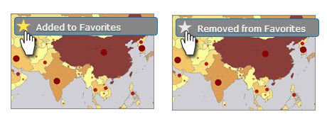
Favorites
You can create a list of favorites from items you find via search or in the Gallery, or have added to My Content. Click the star appearing in the upper left corner of the thumbnail to add or remove from your favorites. For more information see Item details.
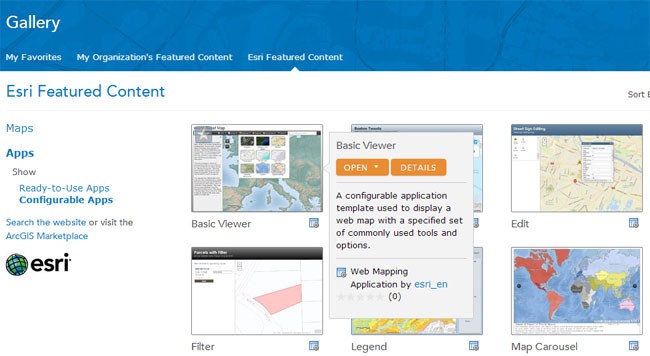
Gallery
View your favorites in a new My Favorites section of the Gallery. The Gallery has been redesigned to make it easy to find your favorites, featured content from your organization, and featured content from Esri.
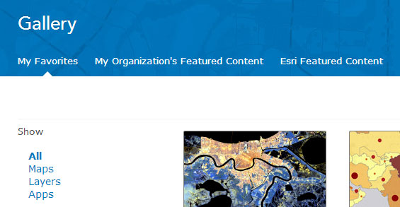
Gallery sort and filter tools have also been improved, and a new list display option is available.
+++
Map Viewer
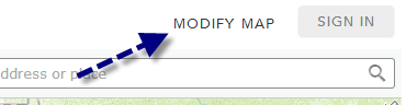
View only mode when not logged in
A simplified map viewer opens if the user has not logged in to their account. Capabilities such as Save, Add, Get Directions, Manage Bookmarks, and some layer options are not available, making the map viewer easier to use for casual, anonymous users of your maps. Sign in or click Modify Map to enable all map viewer capabilities.
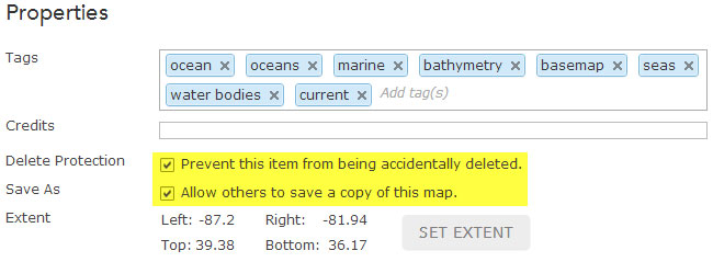
Map copy / delete protection
Map authors can disable Save As to prevent users from saving copies of their maps. Maps (and other items) can also be protected from accidental deletion. Save As and Delete Protection can be set when editing the map item details.
+++
Map Layers
Add from favorites
You can search for layers to add to your map from your favorites. See Add layers.
Copy layer
Map authors can copy a layer in their map and configure different properties on the copied layer, such as pop-ups and symbols. The copied layer and its properties can be saved as a new item for use in other maps. See Copy and save layers.
Save map feature layers
Feature layers you import to your map, such as those created from CSV files and map notes, can now be saved as new items to My Content. These layers become referenced in the map, and changes made from the map are saved in the item if you are the item owner.
Disable time animation
Time-enabled layers now offer the option to disable the time animation so the time slider does not appear on the map. See Configure time settings for more information.
GeoRSS symbols
Symbols for GeoRSS layers can be changed, making it easy to distinguish between multiple GeoRSS feeds in your map.
More symbolization options
You can now rotate point symbols using a rotation value stored in a field allowing the symbol to show direction. For example, symbols can be rotated to show the direction of wind, or the direction a vehicle is traveling.
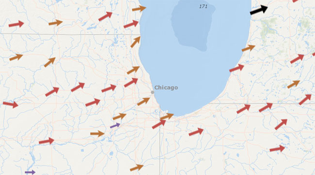
A new collection of arrow symbols has been added that can be used for showing direction.
Other capabilities include new normalization options, the ability to vary the width of lines, and adding graduated point symbols to polygons.
See Change symbols for more information.
Map notes text
Map notes now includes interactive text that can added, sized, and rotated. See Map notes for more information.
Save Layer
Save Layer replaces Save Item Properties in layer options. Use Save Layer to save layer configurations you’ve made to your existing items, as well as to save layers as new items.
+++
CityEngine Web Viewer
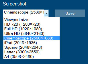
Screenshot tool
A new screenshot tool has been added that offers a choice of resolutions and aspect ratios. Select an option, then click save to open the captured scene in a viewer of your choice, or save to a file.
Improved search
Search results are now highlighted in your scene with other features dimmed, making them easier to see. Search has also been optimized for faster response.
Improved Share
The share dialog has been enhanced to provide a number of options for sharing your web scene. You can share via a link, email, Facebook, or Twitter. You can also generate the embed HTML with options for a full or reduced user interface, and autoplay of slides
Other
A dedicated comments panel has been added, making it easier to browse comments and identify author comments from other comments. Mouse navigation has also been changed to provide a more natural experience when navigating web scenes.
+++
Apps
Ready-to-Use Apps and Configurable Apps can now be displayed and opened directly from the Esri Featured Content section of the Gallery.
App template source code can be downloaded from GitHub, customized, and published from your own server (see Download app templates). GitHub provides a collaborative environment where you can contribute feedback and help enhance the templates.
Other changes include:
- The map viewer template gallery has been updated.
- Many configurable apps include additional options and updated item details.
- The Basic Viewer, Legend, and Panels Search now displays a list of suggested places or addresses as you type.
- The Map Tour and Storytelling Swipe builder applications have been updated with enhanced usability. Map Tour now includes a full screen photo display option. See the Map Tour release notes and Swipe release notes for additional details.
Note: The GPX template has been retired from the map viewer app template gallery. The template is still available via search, and organizations can use the template (and any retired template) to create and publish apps by sharing them to their custom template gallery. See Configure website for more details.
+++
Analysis
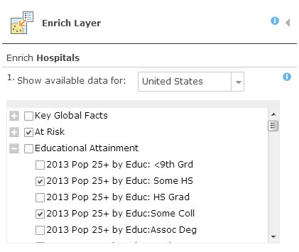
Geoenrichment variable selection
Using Enrich Layer you can now select an entire group of data variables or select from individual variables in each group. Check the box for the entire collection, or click the plus sign to see a list of variables you can choose from.
Data extraction
Use Extract Data to export data line and polygon data to a CSV.
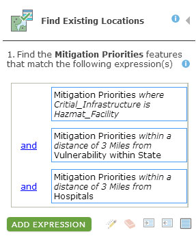
Find locations by spatial and attribute query
Find Existing Locations allows you to discover locations by building queries that use both attributes and spatial relationships.
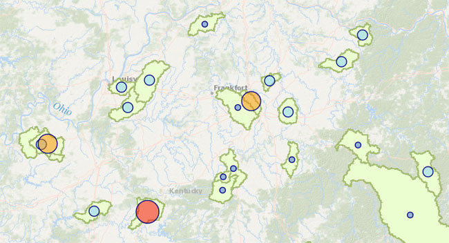
Support for new symbols
Map the results from the Summarize Data tools using the new proportional symbols and get better visual clues for understanding your organization’s data. See Perform analysis for more information.
Live traffic
You can use current traffic conditions when creating drive time areas or determining the nearest locations based on drive time.
+++
Organization Administration
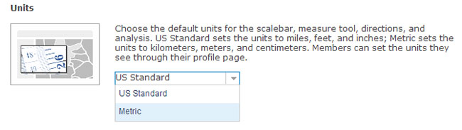
Units
Administrators can configure the default map units for the scale bar, measure tool, directions, and analysis. Organization members can set the units they see via their profile page.
Custom geocoding services
Organizations can use their own custom geocoding services to find places and addresses by configuring utility services. Custom geocoders can be useful for batch geocoding or geocoding your own data. Map configuration options include the ability to choose the geocoder to help find a specific place or address. See Configure utility services for more information.
Default basemap extent
The default basemap in the map viewer can be set to open at the default extent set by the organization. Map configuration now includes options to choose the default extent. See Configure map viewer for more information.
More configuration control
Organizations can choose to automatically include the Esri default basemaps and Esri default templates in the organization groups used to configure the map viewer and configure groups.
Contact link
Organizations can include their own contact link or email in the footer of the organization website. See Configure general settings.
Invitations
Administrators can resend invitations for pending members, and manage expired user names. See Invite users for more details.
Member denial
Administrators can prevent a member from signing in to the organization. See Remove members for more information.
+++
ArcGIS Basemaps and Layers
Tile resampling
Topographic, Street, Imagery, and Imagery with Labels now support tile resampling when zooming in. The message Map data not yet available will no longer display when the maximum resolution of data has been exceeded in isolated locations.
Note: This capability will be enabled with a subsequent basemap server update scheduled to occur post-release.
Basemap and layer updates
Esri basemaps and layers have been updated with the following:
- Basemaps have updated content for India using data from MapMyIndia.
- Recent 30-meter Landsat 8 imagery for the world is now available to ArcGIS subscribers (currently in beta).
- More than 50 countries have been added to the Demographic & Lifestyle maps, bringing the total to over 120 countries.
+++
Other enhancements and changes
Other changes and improvements in this release include the following:
- Help has been reorganized to better highlight the main workflows of ArcGIS Online.
- When you add a CSV file to ArcGIS Online and share it publicly, the details page displays the URL. You can use the URL to reference the CSV as a layer in web apps, pop-ups, and more.
- Delete protection can be enabled on your items you do not want to accidentally remove. Set this to ensure that layers within featured maps, and maps within featured apps, aren’t deleted.
- You can edit the URL of an ArcGIS Server service layer in the item details – handy when you’ve moved to a different server.
- Items added with the same title can now be stored in the same folder.
- Greece and South Africa are now available as regions.
ArcGIS Explorer Online retired
As of December 10, 2013, ArcGIS Explorer Online has been moved to retired phase support. You can no longer open maps in ArcGIS Explorer directly from item details. Items previously associated with Explorer Online now open in the map viewer. You can still open maps using Explorer Online by opening Explorer Online directly. Existing presentations are still available to view, share, and embed from within the map viewer.
For more information
For more information on this latest release, and previous releases, see What’s New.


Commenting is not enabled for this article.