by Robert Kimball and Paul Reig, Aqueduct Project, World Resources Institute
 Water is not just an environmental issue – it has the power to create risks and opportunities that can impact companies, investors, and entire economies. Further proof of this point came from the annual meeting of the World Economic Forum in Davos, where water supply crises were ranked as one of the most likely and highest impact risks facing the world. To thrive sustainably, companies, investors, and governments need a deeper understanding of where and how water risks are emerging worldwide.
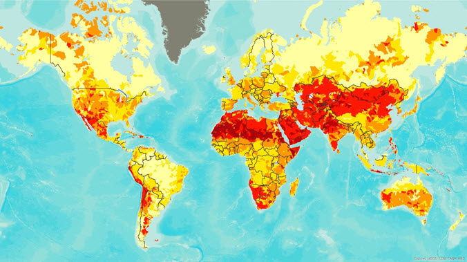
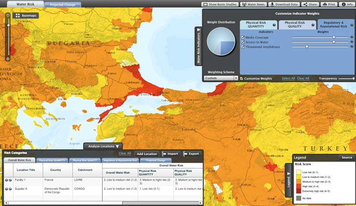
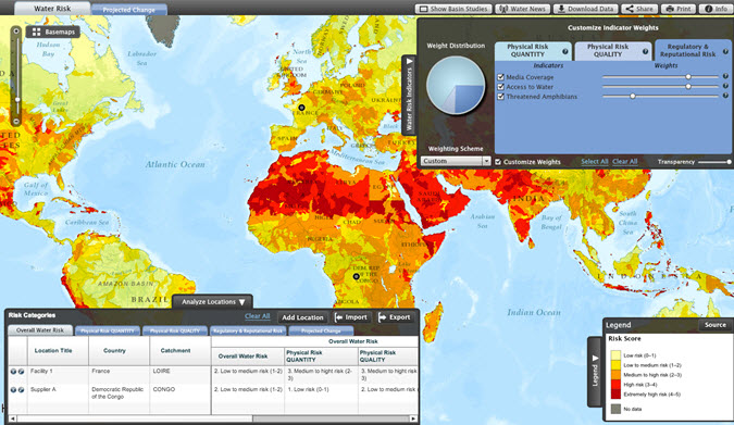
The World Resources Institute’s Aqueduct water risk mapping tool provides unprecedented insight into the complexities of water risk. Aqueduct’s global water risk maps are the product of three years of indicator development, data collection, and modeling. They bring together data on twelve different indicators of water risk – everything from water stress to drought to access to clean drinking water. A free online tool lets users from companies, investors, and beyond combine the twelve indicators together using preset or customized weights to create a global water risk map that is tailored to their specific concerns. Aqueduct is already being used by companies ranging from McDonald’s to Goldman Sachs, as well as the National Intelligence Council and academics and governments worldwide.
Aqueduct is the most up-to-date, comprehensive, and granular water risk mapping platform available today. It features:
- High-resolution maps that display data for 15,000 geographic units worldwide
- Data for a peer-reviewed framework of twelve water risk indicators
- Pre-set and customizable indicator weightings, so that the risk analysis is tailored to your interests or the industry you work in.
- The ability to compare water risk levels between specific locations by adding them manually, or importing sites (up to 250 at a time) from a spreadsheet
Putting Complex Data at your Fingertips
Aqueduct is designed to make scientific and complex research easily accessible and understandable. Our online mapping tool uses ESRI’s web technology and is easy to use and intuitive, even for non-experts in the world of water. In addition, WRI makes all of the data and methodology behind Aqueduct transparent and publicly available – including the GIS shape files which can be downloaded from our website. Our goal is to put the best data available on water risk into the right hands – in companies, investors, governments, academia, and beyond – where it can be used to drive more sustainable water strategies worldwide. All of this was made possible thanks to WRI’s partners in developing Aqueduct – the hydrological modelers at ISciences and the online tool developers at BlueRaster.
Webinar on February 20th
On February 20, 2013 at 11am EST, WRI’s Aqueduct team will host a Data & Methodology Webinar that is open to anyone who would like to learn more about Aqueduct. The webinar will explain our hydrological modeling and data sources, as well as the methodology we used to weigh and aggregate each indicator into physical, regulatory, reputational and overall water risk scores. Please register for this event here and come prepared to ask any follow up questions on this brand new tool.


Article Discussion: