Preparing source data for contributing to Esri Community Maps isn’t complicated, but it does involve migrating the basemap layers you want to contribute into the geodatabase schema of the Local Government Information Model (LGIM). At first glance this can seem a little overwhelming, but in truth, Community Maps contributors only need to be concerned with a handful of the many feature classes and attributes in the model. The real challenge is understanding just which feature classes are relevant to Community Maps and how they correspond to the basemap layers from your source data.
The Local Government Information Model and Community Maps story map is the latest resource from the Esri Community Maps team to help illustrate the relationship between the LGIM and Community Maps. Story maps are an exciting new way to communicate a concept in a visual and easy to understand manner, so using one to describe the feature classes from the LGIM that are used to build the World Topographic Map is a natural fit.
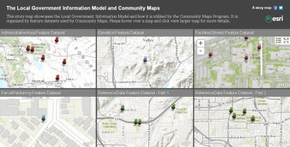
This story map uses the Map Matrix template and features six panels which display map services representing the LGIM feature datasets that contain feature classes relevant to Community Maps. Push pins in the map services show the location of features in the World Topographic Map so that contributors not only learn which feature classes from the LGIM to use, but can also understand the types of geographic data the feature classes represent. This is especially important for some of the more generically named feature classes, such as FacilitySite, which is used to represent all kinds of different facilities and land use (commercial, educational, recreational, etc.).

Each map service panel in the story map is dynamic, and can be expanded to full screen viewing. Users can click on a push pin to reveal a pop-up dialog with an explanation of the feature class and a link to the Local Government Information Model data dictionary, where they can get comprehensive information about the particular feature class.
We hope that this new tool, along with our other resources, such as our workshop videos, Online Help and ArcUser tutorials help demystify the process of migrating basemap source data to the Local Government Information Model for Community Maps contribution. We encourage you to give it a try and let us know what you think.

Commenting is not enabled for this article.