by Ernest To1*, Carissa Belsky3, David Harkins1, Jim Patek2, Steve Stecher3, Mel Vargas2, Jennifer Walker4
1RPS Espey
2Parsons Corporation
3Crespo Consulting Services, Inc.
4Watearth, Inc.
*corresponding author
 From 2011 to 2012, the Texas Water Development Board funded a study (TWDB Contract#:1004821120) to evaluate sedimentation risks for 194 major reservoirs in the state of Texas (see the previous Hydro Blog). The ultimate goal of the study was to support watershed protection planning to protect water quality and water availability in Texas reservoirs.
The associated GIS data and map products from this statewide study are now available to the GIS community, and can be downloaded here.
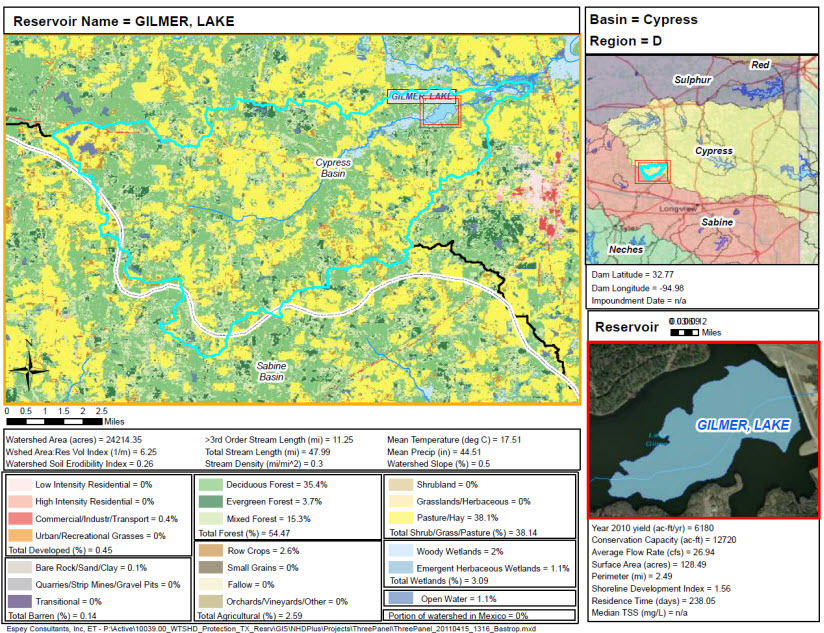
The GIS data are provided in an ArcGIS Map Package. This package contains GIS layers related to the watersheds of Texas reservoirs. These include watershed landuse, landcover, soil erodibility, stream hydrography; and descriptive reservoir statistics (e.g. conservation capacity, yield, residence time, etc). Sources of the information include the National Hydrography Dataset (NHDPlus), United States Geological Survey (USGS), Texas Water Development Board (TWDB) and the Texas Commission for Environmental Quality (TCEQ).
The Map Package also contains an ArcMap project that was used to generate a series of maps in pdf format that displayed sedimentation-related information for each major Texas reservoir. The reservoir maps are organized by Texas river basin (e.g. Colorado, Guadalupe, Red River) and are sequenced from most upstream to downstream. The maps are available here.
The associated report from this study can be found on the TWDB website at: http://www.twdb.state.tx.us/publications/reports/contracted_reports/doc/1004821120_reservoirs.pdf.


Article Discussion: