By Aileen Buckley, Mapping Center Lead
There are three primary building blocks of standard symbols in ArcGIS – colors, fonts, and graphic files. In this article, we focus on fonts for standard 2D symbols in ArcGIS. In other blog entries, we discuss colors and pictures in ArcGIS symbols. Here, we discuss fonts used in character marker symbols, marker line symbols, and marker fill symbols. We also discuss the need to install fonts so that symbols display correctly and to embed fonts in shared output documents.
Things are a little different for 3D symbols and symbols in cartographic representations, so here we are really focusing on fonts for 2D standard symbols in ArcGIS.
What a font is
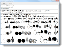
A font is a complete set of characters in a particular size and style of type. You’re probably familiar with fonts such as Arial or Times New Roman. All fonts contain glyphs, but in some fonts the glyphs are pictorial rather than alphanumeric (figure 1). Be aware that not all fonts contain all the characters in another font. For example, font you choose to use for the English language may not contain diacritical marks that would be required for another language.
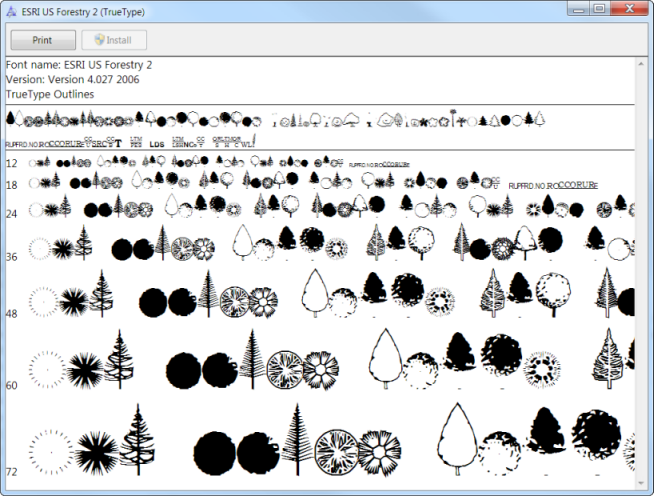
Figure 1. The Esri US Forestry 2 font contains graphic glyphs rather than alphanumeric glyphs
How fonts are used in ArcGIS symbols
Fonts can be used to create what are called character marker symbols in ArcGIS. These can be used to symbolize points (figure 2).
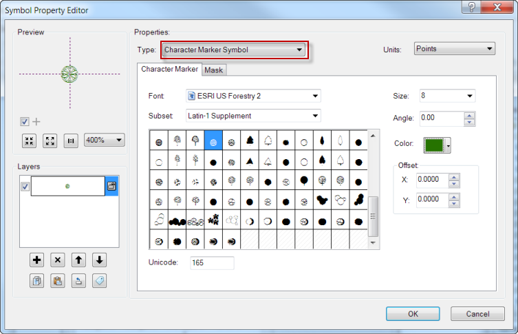
Figure 2. A character marker symbol in the Symbol Property Editor dialog
Character marker symbols can also be used to symbolize lines and polygons. Character markers symbols can be placed along lines in marker line symbols in marker line symbols (figure 3), although this is not a very common use of fonts in ArcGIS symbols.
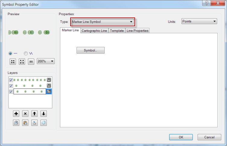
Figure 3. A marker line symbol
More often, they are used to create patterns in marker fill symbols (figure 4). The character markers in these symbols can be gridded (e.g., trees in an orchard) or random (e.g., trees in a forest).
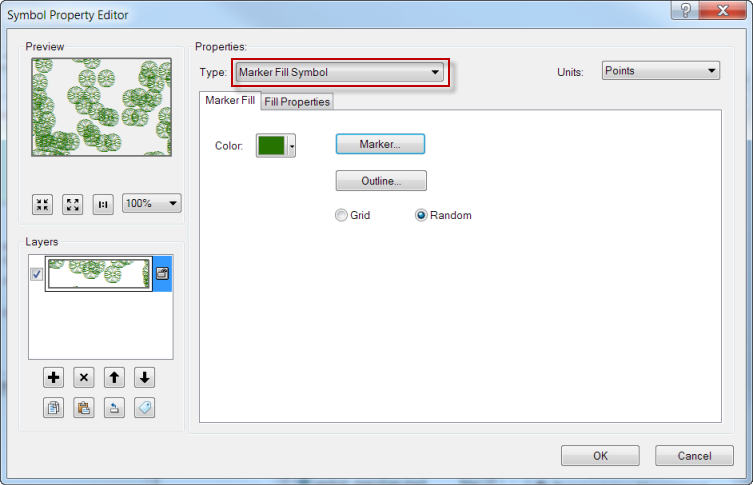
Figure 4. A marker fill symbol
There are a few things you should know about fonts before you use them to create ArcGIS symbols.
Types of fonts
There are many different kinds of fonts, but ArcGIS uses either TrueType, OpenType or TypeOne fonts. You can tell what kind it is by the icon shown in the font drop down in the Symbol Property Editor dialog box (figure 5).
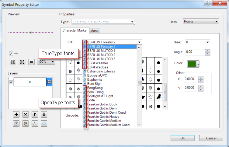
Figure 5. The type of font is identified by the icon
Adding fonts to the fonts directory
For symbols to appear correctly in ArcMap, the fonts that are used in marker symbols need to be installed in the fonts directory on your computer. This is usually located in C:WindowsFonts. To install the font, right-click the font file or files (e.g., esri_135.ttf), and click Install which will automatically copy the files into the fonts directory (figure 6).
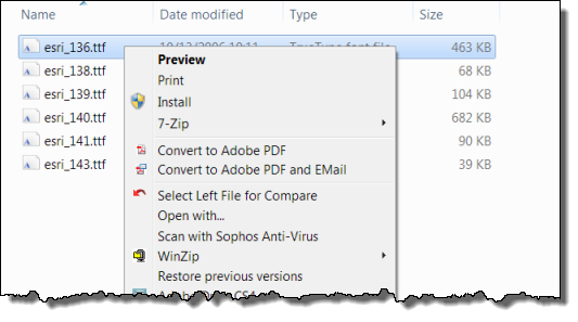
Figure 6. Installing fonts in the Windows fonts directory
Sharing ArcGIS documents with character marker symbols
A critical thing to know is that if you want to share your ArcMap, ArcScene, or ArcGlobe document with others, they also need to have the font on their machine in order for the symbol to appear correctly. If they don’t, the marker symbol will undergo a font substitution and will be replaced with a character from a different font. Don’t forget that you may need to check the permission on the font you want to share.
Sharing exported maps
If you want to share a map that you export, you can embed the font in the output document so that users who do not have fonts installed on their computer can still view the proper symbology.
The ten supported export formats for ArcMap are listed below.
| File format | Does the format support font embedding? |
| AI (Adobe Illustrator) | NO—The Adobe Illustrator file format that ArcMap writes does not support font embedding |
| BMP (Microsoft Windows Bitmap) | NA—BMP files are raster images, so no font embedding is required. |
| EMF (Windows Enhanced Metafile) | NO—EMF does not support font embedding. |
| EPS (Encapsulated PostScript) | YES—files exported from ArcMap support embedding. |
| GIF (Graphic Interchange Format) | NA—GIF files are a legacy raster format, so no font embedding is required. |
| JPEG (Joint Photographic Experts Group) | NA—JPEG files are image files, so no font embedding is required. |
| PDF (Portable Document Format) | YES—PDF exports from ArcMap support embedding of fonts. |
| PNG (Portable Network Graphics) | NA—PNG is raster format, so no font embedding is required |
| SVG (Scalable Vector Graphics) | YES—SVG supports font embedding. |
| TIFF (Tagged Image File Format) | NA—TIFF files are images, so no font embedding is required. |
If you are exporting from ArcScene or ArcGlobe, you will create a raster graphic, so again, you do not need to worry about font embedding.
Sharing maps on the web
The font has to be installed on the server. Additionally, there may be a permission issue so check the font licensing to make sure you can share the font with others.
To learn more
Here are links to some other resources that relate to using fonts in ArcGIS:
- Creating text symbols
- Understanding text font size
- Improving symbol drawing performance
- Drawing differences between the ArcGIS drawing engines
- Symbolizing data based on unique attribute values
- Fundamentals of 3D symbols and styles
- How to symbolize a point as a 3D character marker not included in a style

Article Discussion: