By Aileen Buckley, Mapping Center Lead
We mentioned a few tips about legend design in our session called “The One Minute Cartographer” at the 2008 Esri User Conference. (The PowerPoint presentation is available for download on the Other Resources page.) We decided to share those tips and some general guidance on legends here since some of you have been asking about legends lately on Ask a Cartographer.
Before adding something to your map, it is always best to ask if it helps your map reader; if not, then do not add that something to your map. Instead of helping your map readers, such additions may actually degrade your map’s effectiveness by drawing attention away from the important content by adding one more level of interpretation for the map reader. They have to ask themselves, “What is this, and how does it relate to the message I am supposed to get from all this?”.
This holds true for legends. So, here are some tips:
- Design your map symbols to be self evident. In most cases, it is desirable to find yourself in a position of being able to eliminate a legend altogether. If the symbology on the map is so obvious to the readers that they do not need to refer to a legend to be able to decipher the map, then there is one less cognitive step required of the map reader and one less opportunity for them to misinterpret what you are trying to convey.
- Rethink using the word “Legend” as the legend title. The legend title is a place where you have the opportunity to give the reader useful information other than the fact that this is the legend. This is especially true for thematic maps. You can use the legend title to describe: how the data values were computed (People per square miles), units of the values (Thousands of acres), sources of data (2001 US GDP from the International Monetary Fund), or other details about the data on the map.
- If the map is a reference map, then the variety of data on the map will probably not allow you to use the legend title to further clarify all the types of data in the legend. In these cases, it is often useful to let the map reader know that what they are looking at is the key to deciphering the map symbols. In these cases, use of the title “Key” or “Legend” may be warranted. The Population Centers maps at the back of the Atlas of Oregon called the key to the symbology “Legend”. An advantage is that most map readers know what a map legend is and what it is used for so using familiar terminology may be helpful to them. But even when you do have such a need for a legend title, you might be able to slip in some additional info about the map by replacing the obvious “Key” or “Legend” with something else. For example, the National Geographic Atlas of the World uses the legend title “Political Map Symbols” – you know this is the legend for one often occurring type of map in the atlas. Perhaps we could have used “Symbols for Maps of Areas with Larger Populations” in the Atlas of Oregon. Then people would know that we included maps that covered only those larger communities – as the text says, “All county seats and most other towns of significant size, including at least 95% of Oregon’s population”.
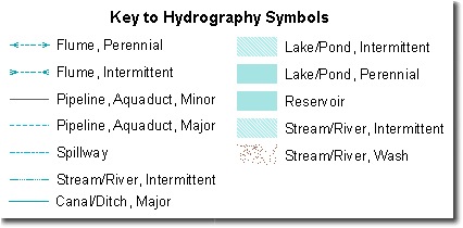
One tip we have, (it was used to create the image at the top of this post) is that you can customize how each of your layers appears in a legend. In this case we removed the layer names from the legend and used our title to address the fact that there were hydro line and fill symbols are shown. To do this:
- Open the legend’s properties and show the Items tab.
- In the items list, select the layer that you want to remove the layer name from in your legend and then click the Style button.
- In the Legend Item Selector window, click Properties.
- In the Legend Item window show the General tab and uncheck the Show Layer Name option.
- Click OK in all the windows to close them.


Article Discussion: